- Lac qui Parle River
Geobox River
name = Lac qui Parle River
native_name =
other_name =
other_name1 =
image_size = 300
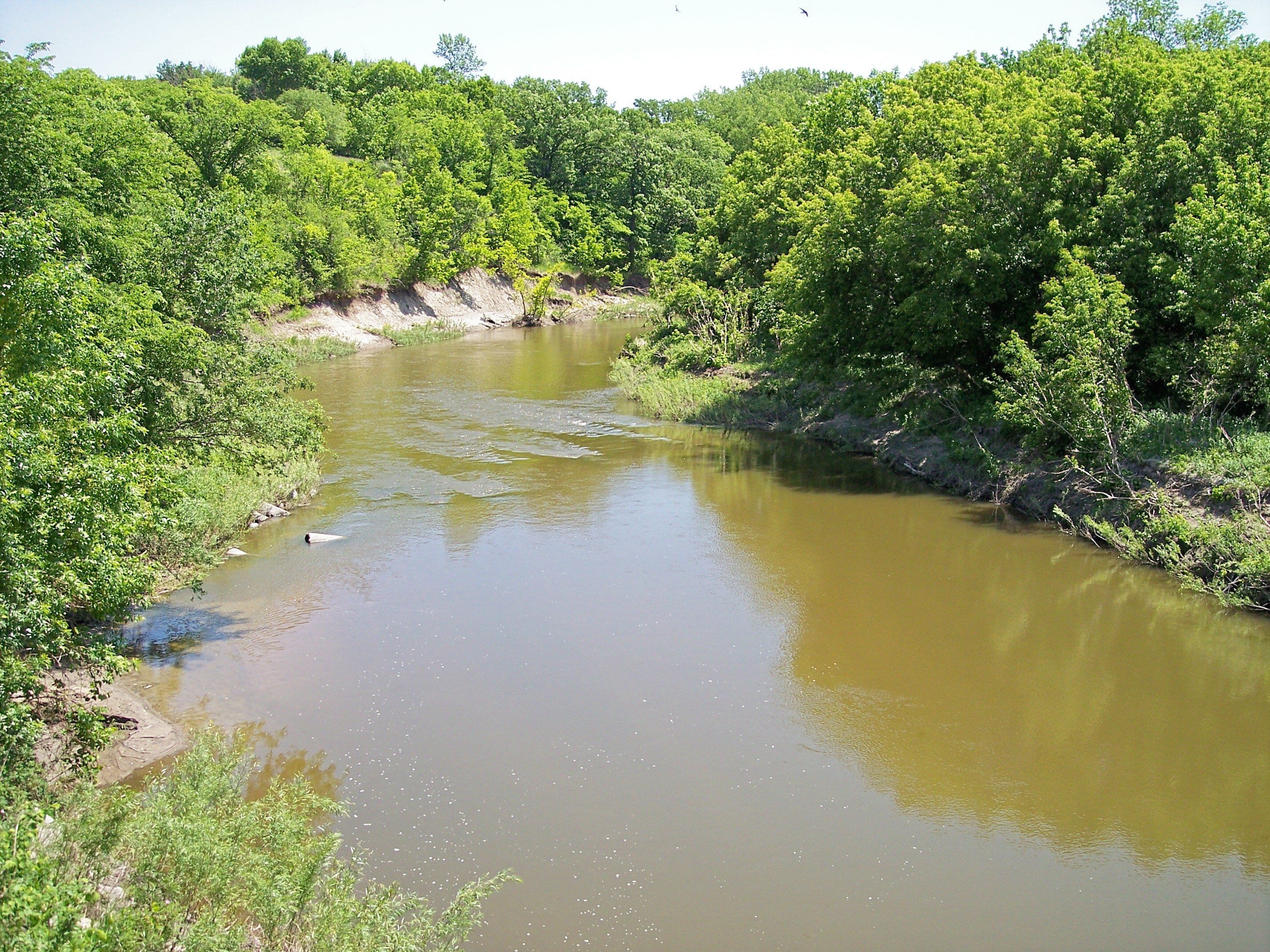
image_caption = The Lac qui Parle River in Lac qui Parle Township in 2007
country = United States
state = Minnesota
region =
region1 =
district =
district1 =
city =
city1 =
length_imperial = 118.3
length_note = cite web |url= http://mrbdc.mnsu.edu/major/lqparle/desc24.html |title= Lac qui Parle River Major Watershed. |pages= [http://mrbdc.mnsu.edu/major/lqparle/descstream24.html Streams within the Lac qui Parle River Major Watershed] |publisher= Minnesota River Basin Data Center.Minnesota State University, Mankato |date= 2000-06-06 |accessdate= 2007-06-05]
watershed_imperial = 1156
watershed_note = cite web |url= http://www.pca.state.mn.us/water/basins/mnriver/watersheds.html |title= Watersheds of the Minnesota River Basin. |pages= [http://www.pca.state.mn.us/water/basins/mnriver/watershed-lacquiparle.pdf Minnesota River Basin: Lac qui Parle Watershed] |publisher= Minnesota Pollution Control Agency |date= 2005-12-01 |accessdate= 2007-06-05]
discharge_location = Lac qui Parle Township
discharge_imperial = 157
discharge_max_imperial = 17100
discharge_min_imperial = 0
discharge_note = cite web |url=http://pubs.usgs.gov/wdr/2005/wdr-mn-05-1/ |pages = [http://pubs.usgs.gov/wdr/2005/wdr-mn-05-1/05300000.2005.sw.pdf Lac qui Parle River near Lac qui Parle, MN] |title=Water Resources Data in Minnesota, Water Year 2005 Annual Report. |first= G. B. |last=Mitton |coauthors=K. G. Guttormson, G. W. Stratton, E. S. Wakeman |publisher=United States Geological Survey |accessdate=2007-06-05]
discharge1_location =
discharge1_imperial =
source_name =Lake Hendricks
source_location = Hendricks
source_district = Lincoln County
source_region =
source_lat_d = 44
source_lat_m = 30
source_lat_s = 17
source_lat_NS = N
source_long_d = 96
source_long_m = 26
source_long_s = 06
source_long_EW = W
source_coordinates_note = cite web |url=Gnis3|646304 |title=Geographic Names Information System entry for Lac qui Parle River (Feature ID #646304) |publisher=Geographic Names Information System |accessdate=2007-06-05]
source_elevation_imperial = 1755
source_elevation_note =Google Earth elevation forGNIS coordinates. Retrieved on2007-06-05 .]
mouth_name = Minnesota River
mouth_location =Lac qui Parle State Park
mouth_district = Lac qui Parle County
mouth_region =
mouth_lat_d = 45
mouth_lat_m = 01
mouth_lat_s = 35
mouth_lat_NS = N
mouth_long_d = 95
mouth_long_m = 52
mouth_long_s = 49
mouth_long_EW = W
mouth_coordinates_note =
mouth_elevation_imperial = 934
mouth_elevation_note =
tributary_left =West Branch Lac qui Parle River
tributary_left1 =
tributary_right =
tributary_right1 =
free_name =
free_value =
map_size =
map_caption =The Lac qui Parle River is a
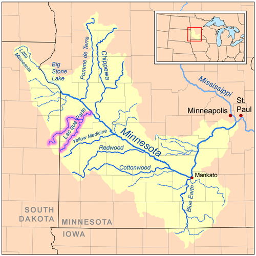
tributary of theMinnesota River , 118 miles (190 km) long, in southwesternMinnesota in theUnited States . A number of tributaries of the river, including its largest, the West Branch Lac qui Parle River, also flow in easternSouth Dakota . Via the Minnesota River, the Lac qui Parle River is part of the watershed of theMississippi River , draining an area of 1,156 square miles (2,994 km²) in an agricultural region. Slightly more than two-thirds of the Lac qui Parle watershed is in Minnesota. "Lac qui parle" means "the lake which speaks" in theFrench language , and was a translation of the Sioux name forLac qui Parle , a lake on the Minnesota River upstream of the mouth of the Lac qui Parle River.cite book| last= Waters |first= Thomas F. | title= The Streams and Rivers of Minnesota |year= 2006 |publisher=University of Minnesota Press |location=Minneapolis |isbn= 0-8166-0960-8 |pages= pp. 288-303 |chapter= The Southwest: Rivers of the Coteau des Prairies]The source of the river is Lake Hendricks on the boundary of
Lincoln County, Minnesota , andBrookings County, South Dakota . It issues from the lake inHendricks, Minnesota , and flows northeastwardly through northwestern Lincoln County as an intermittent stream on theCoteau des Prairies , a morainicplateau dividing the Mississippi andMissouri River watersheds, into western Yellow Medicine County, where it flows off the Coteau, dropping 250 feet (76 m) in eight miles (13 km). Continuing northeastwardly through flattill plain s with occasionalwillow s andcottonwood s along its banks, the river flows into eastern Lac qui Parle County, passing to the east of Dawson. It flows into the Minnesota River just below Lac qui Parle Lake inLac qui Parle State Park , approximately ten miles (15 km) northwest of Montevideo, after flowing through a wooded valley in which it drops 210 feet (64 m) in 18 miles (29 km). Lac qui Parle Lake was formed by a delta at the mouth of the Lac qui Parle River, and is presently maintained by adam .cite book| title= Minnesota Atlas & Gazetteer |year=1994 |publisher=DeLorme |location=Yarmouth, Me. |isbn= 0-89933-222-6 |pages= pp. 28, 36-37]The river's largest tributary, the West Branch Lac qui Parle River, [cite web |url=Gnis3|1258879 |title=Geographic Names Information System entry for West Branch Lac qui Parle River (Feature ID #1258879) |publisher=
Geographic Names Information System |accessdate=2007-06-05] 55 miles (89 km) long, rises on the coteau in easternDeuel County, South Dakota , and flows initially northeastwardly as an intermittent stream, pastGary, South Dakota , then eastwardly through Lac qui Parle County, past Dawson. Other tributaries include two smalltrout streams: Canby Creek, 24 miles (39 km) long, which flows northeastwardly on the Coteau in western Yellow Medicine County, through Canby; and Tenmile Creek, 33 miles (53 km) long, which flows eastwardly and northwardly through Lac qui Parle County, through Boyd. [cite book| title= South Dakota Atlas & Gazetteer |year=2001 |publisher=DeLorme |location=Yarmouth, Me. |isbn= 0-89933-330-3 |pages= p. 35]According to the Minnesota Pollution Control Agency, of the 806 square miles (2,088 km²) of the river's watershed in Minnesota, 79% of the land is used for agricultural cultivation, primarily corn and
soybean s.Flow rate
At the
United States Geological Survey 'sstream gauge near the community of Lac qui Parle in Lac qui Parle Township, the annual mean flow of the river between 1910 and 2005 was 157cubic feet per second (4 m³/s). The highest recorded flow during the period was 17,100 ft³/s (484 m³/s) onApril 10 ,1969 . Readings of zero were recorded on numerous days during several years.ee also
*
List of rivers in Minnesota
*List of rivers in South Dakota External links
* [http://files.dnr.state.mn.us/maps/water_access/counties/lacquiparle_yellowmedicine.pdf Public Water Access: Lac qui Parle & Yellow Medicine Counties]
References
Wikimedia Foundation. 2010.