- Geographic Regions of the Dominican Republic
-
Dominican Republic 
This article is part of the series:
Politics and government of
the Dominican Republic
The Dominican Republic is divided into three geographic regions, which are in turn divided into ten geographic sub-regions.
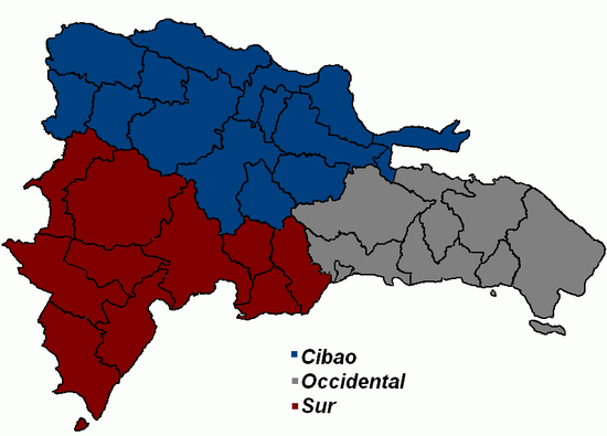
Regional divisions and actual provinces of the Dominican Republic Regions Sub-regions Provinces Cibao Cibao Nordeste[1] Duarte Hermanas Mirabal María Trinidad Sánchez Samamá Cibao Noroeste[2] Dajabón Monte Cristi Santiago Rodríguez Valverde Cibao Norte[3] Espaillat Puerto Plata Santiago Cibao Sur[4] La Vega Monseñor Nouel Sánchez Ramírez Sur Valdesia[5] Azua Peravia San José de Ocoa San Cristóbal El Valle[6] Elías Piña San Juan Enriquillo[7] Barahona Bahoruco Independencia Pedernales Oriental Ozama[8] Distrito Nacional Santo Domingo Higüamo[9] Hato Mayor Monte Plata San Pedro de Macorís Yuma[10] El Seibo La Romana La Altagracia References
- ^ "Region Cibao Nordeste". http://onaplan.gov.do/regionalizacion/Region%20Cibao%20Nordeste.asp. Retrieved 2009.
- ^ "Region Cibao Noroeste". http://onaplan.gov.do/regionalizacion/Region%20Cibao%20Noroeste.asp. Retrieved 2009.
- ^ "Region Cibao Norte". http://onaplan.gov.do/regionalizacion/Region%20Cibao%20Norte.asp. Retrieved 2009.
- ^ "Region Cibao Sur". http://onaplan.gov.do/regionalizacion/Region%20Cibao%20Sur.asp. Retrieved 2009.
- ^ "Region Valdesia". http://onaplan.gov.do/regionalizacion/Region%20Valdesia.asp. Retrieved 2009.
- ^ "Region El Valle". http://onaplan.gov.do/regionalizacion/Region%20El%20Valle.asp. Retrieved 2009.
- ^ "Region Enriquillo". http://onaplan.gov.do/regionalizacion/Region%20Enriquillo.asp. Retrieved 2009.
- ^ "Region Ozama". http://onaplan.gov.do/regionalizacion/Region%20Ozama.asp. Retrieved 2009.
- ^ "Region Higüamo". http://onaplan.gov.do/regionalizacion/Region%20Higuamo.asp. Retrieved 2009.
- ^ "Region Del Yuma". http://onaplan.gov.do/regionalizacion/Region%20Del%20Yuma.asp. Retrieved 2009.
List of regions of North America Sovereign states - Antigua and Barbuda
- Bahamas
- Barbados
- Belize
- Canada
- Costa Rica
- Cuba
- Dominica
- Dominican Republic
- El Salvador
- Grenada
- Guatemala
- Haiti
- Honduras
- Jamaica
- Mexico
- Nicaragua
- Panama
- Saint Kitts and Nevis
- Saint Lucia
- Saint Vincent and the Grenadines
- Trinidad and Tobago
- United States
Dependencies and
other territories- Anguilla
- Aruba
- Bermuda
- Bonaire
- British Virgin Islands
- Cayman Islands
- Curaçao
- Greenland
- Guadeloupe
- Martinique
- Montserrat
- Puerto Rico
- Saint Barthélemy
- Saint Martin
- Saint Pierre and Miquelon
- Saba
- Sint Eustatius
- Sint Maarten
- Turks and Caicos Islands
- United States Virgin Islands
Categories:- Regions of the Dominican Republic
- Lists of country subdivisions
- Country subdivisions of the Americas
- Dominican Republic-related lists


Wikimedia Foundation. 2010.