Maverick County Memorial International Airport

Maverick County Memorial International Airport
Maverick-20feb2002.jpg
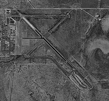
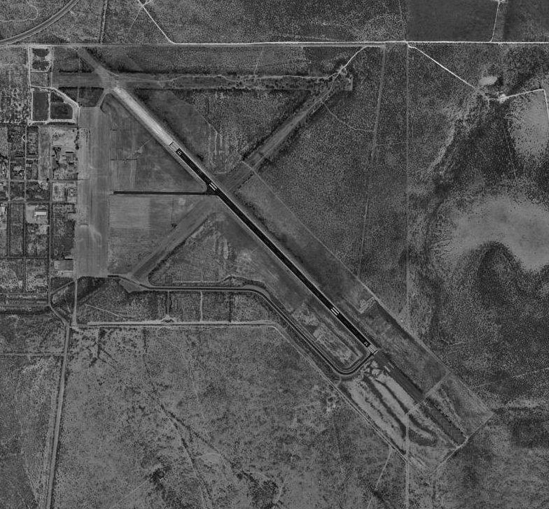
USGS aerial photo, 20 February 2002
IATA: EGPICAO: noneFAA LID: 5T9
Summary
Airport type Public
Owner County of Maverick
Serves Eagle Pass, Texas
Location Radar Base, Maverick County, near Eagle Pass, Texas
Elevation AMSL 887 ft / 270 m
Coordinates 28°51′26″N 100°30′48″W / 28.85722°N 100.51333°W / 28.85722; -100.51333
Runways
Direction Length Surface
ft m
13/31 5,506 1,678 Asphalt
Statistics (2008)
Aircraft operations 600
Based aircraft 2
Source: Federal Aviation Administration[1]
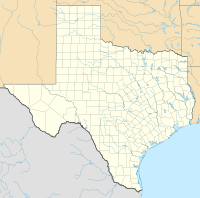
Maverick County MIA is located in Texas
{{{alt}}}
Maverick County MIA
Location of Maverick County Memorial International Airport, Texas
For the military use of the airport, see Eagle Pass Air Force Station

Maverick County Memorial International Airport (IATA: EGPFAA LID: 5T9) is a county-owned public use airport in Maverick County, Texas, United States. It is located eight nautical miles (15 km) north of the central business district of Eagle Pass, Texas.[1]

Facilities and aircraft

Maverick County Memorial International Airport has one asphalt paved runway designated 13/31 which measures 5,506 by 100 feet (1,678 x 30 m). For the 12-month period ending July 28, 2008, the airport had 600 general aviation aircraft operations, an average of 50 per month.[1]

References

  1. ^ a b c FAA Airport Master Record for 5T9 (Form 5010 PDF), effective 2009-07-02.

External links


Wikimedia Foundation. 2010.

Игры ⚽ Поможем написать реферат

Look at other dictionaries:

  • 5T9 — Maverick County Memorial International Airport, Eagle Pass, Texas USA (Regional » Airport Codes) …   Abbreviations dictionary

  • Список аэропортов штата Техас — Соединённых Штатов Америки, сгруппированных по типу. Содержит все гражданские и военные аэропорты штата. Некоторые частные и ныне не используемые аэропорты могут находиться в списке (например, если ФАА зафиксированы коммерческие перевозки или… …   Википедия

  • List of World War II topics (M) — # M 1941 Field Jacket # M 24 (Japanese midget submarine) # M B Etheredge # M class Minesweeper (Germany) # M class minesweeper # M Special Unit # M. A. Yegorov # M. R. D. Foot # M. Z. Kiani # Maori Battalion # Möbelwagen # Möhne Reservoir #… …   Wikipedia

  • Texas World War II Army Airfields — Infobox Military Structure name=Texas World War II Army Airfields partof = World War II location= coordinates= caption= type=Army Airfields code= built=1940 1944 builder= materials= height= used= 1940 Present demolished= condition= ownership=… …   Wikipedia

  • National Register of Historic Places listings in Ulster County, New York — Location of Ulster County in New York Ma …   Wikipedia

  • Liste der IATA-Codes/E — Diese Teilliste führt alle IATA Flughafen Codes auf, die mit „E“ beginnen, und enthält Informationen zu den bezeichneten Verkehrsknotenpunkten. IATA Codes   A B C D E F G H I …   Deutsch Wikipedia

  • United States — a republic in the N Western Hemisphere comprising 48 conterminous states, the District of Columbia, and Alaska in North America, and Hawaii in the N Pacific. 267,954,767; conterminous United States, 3,022,387 sq. mi. (7,827,982 sq. km); with… …   Universalium

  • Texas — This article is about the U.S. state. For other uses, see Texas (disambiguation). State of Texas …   Wikipedia

  • Dates of 2007 — ▪ 2008 January Ladies and gentlemen: on this day, at this hour, it is still within our power to shape the outcome of this battle. Let us find our resolve, and turn events toward victory. U.S. Pres. George W. Bush, asking for support for his… …   Universalium

  • LTV A-7 Corsair II — A 7 Corsair II U.S. Navy A 7E from Attack Squadron 46 (VA 46) Role Attack aircraft Manufacturer …   Wikipedia

Share the article and excerpts

Direct link
Do a right-click on the link above
and select “Copy Link”