- Shire of Nathalia
Infobox Australian Place | type = lga
name = Shire of Nathalia
state = vic
region =
area = 1238.97
est = 1879
seat = Nathalia
pop = 3520 (1992) [cite book|title=Victorian Year Book|author=Australian Bureau of Statistics, Victoria Office|year=1994|page=52|id=ISSN 0067-1223]
logosize =
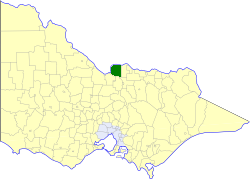
caption = Location in Victoria
county = Moira
near-nw = "Murray (NSW)"
near-n = "Berrigan (NSW)"
near-ne = "Berrigan (NSW)"
near-w = "Murray (NSW)"
near-e = Numurkah
near-sw = Deakin
near-s = Rodney
near-se = Shepparton
_noautocat = yesThe Shire of Nathalia was a Local Government Area located on the
Murray River in theGoulburn Valley region about convert|220|km|mi|0 north ofMelbourne , the state capital of Victoria,Australia . The shire covered an area of convert|1238.97|km2|sqmi|1, and existed from 1879 until 1994.History
Nathalia was once part of the vast Echuca District, formed in 1864 and a Shire from 1871, which extended along the south bank of the
Murray River from Mount Hope Creek in the west to theOvens River in the east.It was first incorporated in its own right as the Shire of Shepparton on 30 May 1879. The southeastern section containing Shepparton itself split away on 18 September 1884, and was initially known as the Shire of South Shepparton. On 11 April 1885 the Shire of Shepparton was renamed "Numurkah", and South Shepparton was renamed "Shepparton" some months later. On 30 May 1892, Numurkah annexed the Moira Ward of Echuca, setting the shire's southwestern boundary at the Goulburn River.
Some acrimony developed between the towns of Nathalia and Numurkah, which ended in 1957 with the Shire being renamed Nathalia, and the
Shire of Numurkah severing and incorporating on 30 May 1957.cite book|title=Victorian Municipal Directory|year=1992|publisher=Arnall & Jackson|location=Brunswick|pages=784-785 Accessed atState Library of Victoria , La Trobe Reading Room.] [cite web|url=http://web.archive.org/web/20030618201539/www.arts.monash.edu.au/ncas/multimedia/gazetteer/list/numurkah.html|title=Australian Places - Numurkah|year=1999|date=2008-01-06] The Shire, with an estimated population of 3,650 in 1958, did not grow significantly between then and its amalgamation.On 18 November 1994, the Shire was abolished, and merged with the Shires of Cobram, Numurkah, Tungamah and Yarrawonga into the
Shire of Moira . [cite book|url=http://www.ausstats.abs.gov.au/ausstats/free.nsf/0/76E601D6DB55E88ACA25722500049195/$File/12570_1994-95.pdf|title=Victorian local government amalgamations 1994-1995: Changes to the Australian Standard Geographical Classification|author=Australian Bureau of Statistics |date=1 August 1995|publisher=Commonwealth of Australia|page=9|isbn=0-642-23117-6|accessdate=2008-01-05]Wards
Nathalia was divided into four ridings on 30 May 1957, each of which elected three councillors:
* Broken Riding
* Goulburn Riding
* Murray Riding
* Yalca RidingTowns and Localities
* Nathalia
* Barmah
* Kaarimba
* Kotupna
* Picola
* Waaia
* Yalca
* YielimaPopulation
* Estimate in the 1958 Victorian Year Book. + The combined population for Numurkah and Nathalia in 1958 is given as 8,850.
References
Wikimedia Foundation. 2010.