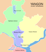
- Dagon Seikkan Township
-
Dagon Seikkan Township
ဒဂုံဆိပ်ကမ်း မြို့နယ်— Township of Yangon — Dagon Seikkan Township Coordinates: 16°51′24″N 96°16′58″E / 16.85667°N 96.28278°ECoordinates: 16°51′24″N 96°16′58″E / 16.85667°N 96.28278°E Country Burma (Myanmar) Region Yangon City Yangon Township Dagon Seikkan Area - Total 85.4 km2 (32.973 sq mi) Population (December 2008)[1] - Total 93,823 - Density 1,098.6/km2 (2,845.4/sq mi) Time zone MST (UTC+6:30) Postal codes 11441 Area code(s) 1, (80, 99: mobile) [2] Dagon Seikkan Township (Burmese: ဒဂုံဆိပ်ကမ်း မြို့နယ်, pronounced [dəɡòuɴ sʰeiʔkáɴ mjo̰nɛ̀]) is an urban township of Yangon, Burma (Myanmar). Located in the east-central part of the city of Yangon (Rangoon). Satellite communities and industry moved into the township in the 1990s, growing from a rural population of under 10,000 to almost 100,000 by 2010. As of 2009[update], Dagon Seikkan consisted of 39 wards and five village tracts.[1] As of 2000[update], the township had 10 primary schools, two middle schools and a high school.[2] The township is in an industrial area of the city.[1] Nationalities Youth Resource Development Degree College is located in the township.[3]
As of 2007[update], Dagon Seikkan is linked to Thanlyin Township by the Dagon Bridge, the second bridge to be built across the Bago River at Yangon.[4]
Borders
Dagon Seikkan Township shares borders with Hlegu Township to the north, South Dagon Township to the northwest, Thaketa Township to the southwest, and Thanlyin Township to the east and southeast. It borders on the Bago River to the east and southeast.
Notes
- ^ a b c "Profile Dagon Myothit (Seikkan) Township" April 2009, Myanmar Management Information Unit (MIMU)
- ^ a b "Dagon Seikkan Township". Yangon City Development Committee. http://www.yangoncity.com.mm/maps/townships_pro.asp?tname=dagon%28seikkan%29. Retrieved 2010-12-30.
- ^ "Nationality Youths Resource Development Degree College (Yangon)" from The New Light of Myanmar 6 July 2005, last accessed 30 December 2010
- ^ "Dagon Bridge inaugurated in Dagon Myothit Seikkan Township". The New Light of Myanmar. 2007-10-28. http://www.myanmargeneva.org/07nlm/n071028.htm.
Districts/Townships of Yangon Western District
(Downtown)Ahlon Township · Bahan Township · Dagon Township · Kyauktada Township · Kyimyindaing Township · Lanmadaw Township · Latha Township · Pabedan Township · Sanchaung Township · Seikkan Township ·Eastern District Botataung Township · Dagon Seikkan Township · East Dagon Township · North Dagon Township · North Okkalapa Township · Pazundaung Township · South Dagon Township · South Okkalapa Township · Thingangyun TownshipNorthern District Hlaing Township · Hlaingthaya Township · Insein Township · Kamayut Township · Mayangon Township · Mingaladon Township · Shwepyitha Township · Yankin TownshipSouthern District Yangon Region Capital: Yangon Western District
(Downtown)Ahlon Township · Bahan Township · Dagon Township · Kyauktada Township · Kyimyindaing Township · Lanmadaw Township · Latha Township · Pabedan Township · Sanchaung Township · Seikkan Township

Eastern District Botataung Township · Dagon Seikkan Township · East Dagon Township · North Dagon Township · North Okkalapa Township · Pazundaung Township · South Dagon Township · South Okkalapa Township · Thingangyun TownshipNorthern District Hlaing Township · Hlaingthaya Township · Insein Township · Kamayut Township · Mayangon Township · Mingaladon Township · Shwepyitha Township · Yankin TownshipSouthern District Townships outside Yangon City Coco Island Township · Hlegu Township · Hmawbi Township · Htantabin Township · Kawhmu Township · Kayan Township · Kungyangon Township · Kyauktan Township · Taikkyi Township · Thanlyin Township · Thongwa Township · Twante TownshipMain cities and towns Administrative divisions of Burma (Myanmar) States 
Regions Self-Administered Zones Self-Administered Divisions WaUnion Territories Categories:- Townships of Yangon
Wikimedia Foundation. 2010.


