- Coco Islands
-
For other uses, see Cocos Island (disambiguation).
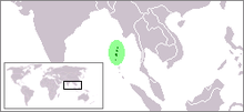 Location of the Andaman island arc.
 Andaman Islands, with Coco Islands at the extreme top of the map.
Coco Islands are a pair of strategically important islands located in the eastern Indian Ocean, politically administered by Burma under Yangon Division. They are allegedly leased to the People's Republic of China since 1994.[1] Both the government of Burma and the People's Republic of China do not comment on this issue, while many members of the Burmese military categorically deny any agreement at all.[2]
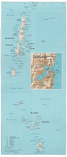
Geographically, they are a part of the Andaman Islands archipelago and separated from the North Andaman Island (India) by the 20 kilometres (12 mi) wide Coco Channel. The Bay of Bengal lies to the west and the Andaman Sea to the east of the islands. The Burmese mainland is 300 kilometres (190 mi) to the north.
The Coco Islands consist of the main Great Coco Island and the smaller Little Coco Island, separated by the Alexandra Channel. Table Island, a third small island located near the Great Coco Island, previously housed a lighthouse but is presently uninhabited.[3]
Contents
History
Formerly Indian possessions, they were taken over by the East India Company in the eighteenth century. They are located on an ancient trade route between India, Burma and Southeast Asia, and there were numerous visits by traders, seafarers and pirates. In 1858, a large prison was built at Port Blair on South Andaman Island, mainly to house the thousands of ‘mutineers’ sent there after the 1857 Indian rebellion, and the Coco Islands were used as a source of food for the struggling penal colony, mainly by providing coconuts. The lack of close supervision caused by the islands isolation prompted the colonial authorities in Calcutta to transfer jurisdiction of the 3 main islands and three small satellite islands to Rangoon, which by then was Britain’s administrative capital in Lower Burma. In 1882 the Coco Islands officially became part of British Burma. When Burma separated from India in 1937 and became a self-governing Crown Colony, the Coco Islands remained Burmese territory. In 1942, along with the rest of the Andaman and Nicobar chain, they were invaded by the Japanese. After Burma regained its independence from Britain in 1948, the Islands passed to the new Union of Burma. A statement by Indian Defence Minister George Fernandes to the BBC in 2003, that Prime Minister Jawaharlal Nehru had ‘donated’ the Coco Islands to Burma in the 1950s, and thus surrendered a vital strategic asset, was incorrect. A penal colony was established on Great Coco Island in 1959 by General Ne Win’s interim military administration. After Ne Win’s coup d’etat in 1962, and the installation of a military government, the prison gained the reputation of being a Burmese ‘Devil’s Island’. In 1969, it was enlarged to cater to an increased number of political prisoners. After a strike, all prisoners on the island were transferred to Rangoon’s Insein Jail in 1971. After the closing of the penal colony the facilities on Great Cocos Island were transferred to the Burmese Navy.[2]
Talks of Chinese Signal Gathering Station and Maritime Army Base
China supposedly established a SIGINT intelligence gathering station on Great Coco Island in 1992 to monitor Indian naval activity in the Andaman and Nicobar Islands.[1] The station is also said to allow China to monitor the movement of other navies and ships throughout the eastern Indian Ocean, especially in the crucial point in shipping routes between the Bay of Bengal and the Strait of Malacca.[1] It may also be used to monitor activities at the launch site of the Indian Space Research Organization at Sriharikota and the Defence Research and Development Organization at Chandipur-on-sea. The Chinese Army is also building a maritime base on Little Coco Island.[4]
Existence of the Chinese base has been questioned.[2] India’s chief of naval staff is quoted as saying in October 2005 that India had “firm information that there is no listening post, radar or surveillance station belonging to the Chinese on Coco Islands.”[2] In 1998 the U.S. stated that it had not detected any significant Chinese activity in Burma.[5] Now, again there are news that China has started its operations again in the same region, and has put up a Listening Post.[6]
Burma’s armed forces continue to operate a small naval base on Great Coco Island. Given its strategic location, it would be surprising if this base did not have a modest intelligence gathering role. If so, the equipment used to perform such a function would probably be Chinese, and it is possible that PLA personnel occasionally visit the island to provide technical assistance. This appears to occur at the other small surveillance and maritime navigation sites dotted around Burma’s long coastline.
On Great Coco Island, commercially available satellite imagery of the period 2006-2008 shows an airfield where the old coconut plantation used to be. There is also a small radar dish, a radio aerial, a jetty and a number of buildings, none of which can be considered unusual. There are no signs of a large base with accommodation for hundreds of servicemen, let alone the radomes, aerial farms and other such installations that characterise major electronic intelligence stations. There are a few buildings on Little Coco Island, and the old lighthouse and its ancillary buildings remain on Table Island, but neither of these islands shows any signs of military activity.[7]
Great Coco Island
Great Coco Island (14°07′00″N 93°22′03″E / 14.1166667°N 93.3675°E) is approximately 10 km (6.2 mi) long and 2 km (1.2 mi) wide.
Many green turtles nest on the beaches of the Great Coco Island. A series of research programs on marine turtle conservation have been conducted by Burma's Department of Fisheries. Data collection on tissue samples of green turtles for population genetic and tagging studies was conducted at Great Coco Island from March to April 2006. Prior to this, Great Coco Island had never been surveyed for marine turtle conservation by Department of Fisheries due to its remote location. The survey found an estimated 150 sea turtles nesting and between 90,000 and 100,000 hatchlings and juveniles.
Little Coco Island
Little Coco Island lies 15 km (9.3 mi) to the southwest from the Great Coco Island. It is approximately 5 km (3.1 mi) long and 1 km (0.62 mi) wide.
References
- ^ a b c Coco Island - Chinese Intelligence Agencies
- ^ a b c Selth, Andrew (9 January 2007) "Irrawaddy: Chinese whispers: The Great Coco Island mystery" BurmaNet News
- ^ Rowlett, Russ. "Lighthouses of Myanmar (Burma)". The Lighthouse Directory. University of North Carolina at Chapel Hill. http://www.unc.edu/~rowlett/lighthouse/mmr.htm.
- ^ "Intelligence station on Great Coco Island is the most important Chinese electronic intelligence installation in Myanmar". GlobalSecurity.org. 2008-02-26. http://www.globalsecurity.org/intell/world/china/coco.htm. Retrieved 2008-02-26.
- ^ [1]
- ^ [url=http://www.organiser.org/dynamic/modules.php?name=Content&pa=showpage&pid=312&page=11]
- ^ Great Coco Island, Google Maps [url=http://maps.google.com/?ie=UTF8&t=k&om=1&ll=14.137117,93.367524&spn=0.03013,0.040169&z=15]
Sources
- Indian Ocean - South-East Asian Marine Turtle Memorandum of Understanding
- Google Earth map of Chinese facilities at Great Coco Island
See also
- List of islands of Burma
- Foreign relations of Burma
Categories:- Islands of Burma
- Islands of the Indian Ocean


Wikimedia Foundation. 2010.