Demographic maps of San Francisco, California
- Demographic maps of San Francisco, California
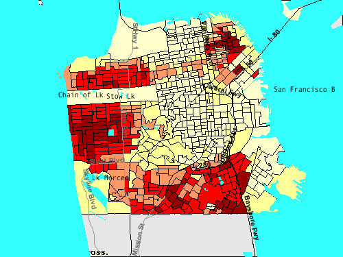
These thematic maps of San Francisco, California illustrate the different neighborhoods and the contrasting demographics of the diverse city. Please click on the images for a larger view or for more information on it. The images are generated at the U.S. Census Bureau's American Factfinder. [ [http://factfinder.census.gov American FactFinder ] ] Treasure Island is inhabited but not shown; uninhabited islands (Farallon Islands, Red Rock Island) are not shown.
Racial and ethnic groups
[
 African American population]
[
 Latino population]

 Caucasian or white population
 ">
">
Asian population
Age and sex
Economy
[
 income]
[
 income]
[
 poverty level]
[
 Unemployment rate]
See also
* San Francisco, California
References
Wikimedia Foundation.
2010.
Look at other dictionaries:
San Francisco, California — Infobox Settlement official name = City and County of San Francisco nickname = The City by the Bay, The CityFact|date=October 2008, Frisco, [cite news last = Sullivan | first = James title = Frisco, that once verboten term for the city by the bay … Wikipedia
Marina District, San Francisco, California — The Marina District is one of the northern districts of San Francisco, California. The area is bounded to the east by Van Ness Ave, on the west by Lyon Street and the Presidio, on the south by Lombard St. The neighborhood sits on the site of the… … Wikipedia
San Francisco — This article is about the city and county in California. For other uses, see San Francisco (disambiguation). San Francisco City and county City and County of San Francisco … Wikipedia
San Francisco Bay Area — Bay Area redirects here. For other uses, see Bay Area (disambiguation). Not to be confused with San Francisco Bay Area Combined Statistical Area. San Francisco Bay Area Common name: San Fran … Wikipedia
North Beach, San Francisco — Coordinates: 37°48′1.04″N 122°24′36.66″W / 37.8002889°N 122.4101833°W / 37.8002889; 122.4101833 … Wikipedia
Marina District, San Francisco — Marina District Neighborhood of San Francisco The Palace of Fine Arts, one of the two surviving buildings of the Panama Pacific International Exposition … Wikipedia
California — Californian, adj., n. /kal euh fawrn yeuh, fawr nee euh/, n. 1. a state in the W United States, on the Pacific coast. 23,668,562; 158,693 sq. mi. (411,015 sq. km). Cap.: Sacramento. Abbr.: CA (for use with zip code), Cal., Calif. 2. Gulf of, an… … Universalium
San Diego — This article is about the city in California. For the metropolitan area, see San Diego metropolitan area. For other meanings of San Diego , see San Diego (disambiguation). San Diego City City of San Diego … Wikipedia
San Miguel de Allende — Infobox World Heritage Site WHS = Protective town of San Miguel and the Sanctuary of Jesús Nazareno de Atotonilco State Party = MEX Type = Cultural Criteria = ii, iv ID = 1274 Region = Latin America and the Caribbean Year = 2008 Session = 32nd… … Wikipedia
Demographics of California — California Population Density Map. California is the most populous U.S. state. It has many people from a wide variety of ethnic, racial, national, and religious backgrounds. The state continues to attract significant numbers of immigrants, and… … Wikipedia