- Cerro El Pital
-
"El Pital" redirects here. For the Colombian municipality, see Pital.
Cerro El Pital 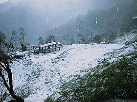
Elevation 2,730 m (8,957 ft) [1] Prominence 1,530 m (5,020 ft) [1] Listing Country high point
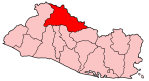
UltraLocation Location of Cerro El Pital in El Salvador (on Honduran border)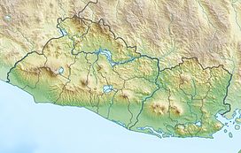
 Cerro El Pital
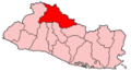
Location Chalatenango Department,  El Salvador – Honduras
Range Sierra Madre Coordinates 14°23′00″N 89°07′00″W / 14.3833333°N 89.1166667°WCoordinates: 14°23′00″N 89°07′00″W / 14.3833333°N 89.1166667°W[1] Cerro El Pital is a mountain in Central America, on the border of El Salvador and Honduras. It is located 12 km (7 mi) from the town of La Palma and at a height of 2,730 m (8,957 ft) it is the highest point of the Salvadoran territory. It is a mountain in the middle of a cloudy forest that has an average annual temperature of 10 °C (50 °F).[2]
It is one of the most touristic places of the country with many endangered plants and animals with a wide altitudinal range and thus a big biodiversity. The cloud forest in the esesmiles has rare fauna and flora for the country, it has quetzales and other endangered species.
In the months of November to February the temperature is between 10 and -4 degrees Celsius and the other months the temperature is between 20 and 5 degrees Celsius. Is the coldest place in El Salvador, it is also the only known place where there is snowfall in the country. On 13 April 2004, the temperature hit record lows and much of the hill was covered by a frost and ice that caused commotion among the local community.[3]
Climate
Climate data for Cerro El Pital, Chalatenango, El Salvador Month Jan Feb Mar Apr May Jun Jul Aug Sep Oct Nov Dec Year Average high °C (°F) 8.5
(47.3)10.2
(50.4)12.5
(54.5)13
(55)14
(57)15
(59)15
(59)14
(57)12
(54)10
(50)8.1
(46.6)6.8
(44.2)11 Average low °C (°F) −3.5
(25.7)−1.8
(28.8)−0.9
(30.4)1.0
(33.8)3.0
(37.4)3.0
(37.4)5.1
(41.2)5.8
(42.4)5.1
(41.2)3.4
(38.1)1
(34)−2.9
(26.8)4 Record low °C (°F) −9.2
(15.4)−7.2
(19.0)−5.5
(22.1)−4.5
(23.9)0
(32)1
(34)1
(34)0
(32)−2.5
(27.5)−2.5
(27.5)−4.8
(23.4)−6
(21)−3.5
(25.7)Precipitation mm (inches) 10.0
(0.394)20.0
(0.787)10.0
(0.394)6.0
(0.236)152.0
(5.984)242.0
(9.528)266.0
(10.472)286.0
(11.26)290.0
(11.417)217.0
(8.543)36.0
(1.417)10.0
(0.394)1,534
(60.39)[citation needed] References
- ^ a b c "Cerro El Pital, El Salvador/Honduras". Peakbagger.com. http://www.peakbagger.com/peak.aspx?pid=8102. Retrieved 17 February 2009.
- ^ "Cerro El Pital" (in Spanish). Ministerio de Turismo de la República de El Salvador. 2005. Archived from the original on 2 May 2006. http://web.archive.org/web/20060502170351/http://www.elsalvadorturismo.gob.sv/pital.htm. Retrieved 17 February 2009.
- ^ Villarroel, Nathalie (13 April 2004). "El cerro El Pital fue cubierto por escarcha" (in Spanish). El Diario de Hoy. http://www.elsalvador.com/noticias/2004/04/13/elpais/pais6.asp. Retrieved 17 February 2009.
Capital: Chalatenango, Chalatenango Municipalities Agua Caliente · Arcatao · Azacualpa · Chalatenango · Citalá · Comalapa · Concepción Quezaltepeque · Dulce Nombre de María · El Carrizal · El Paraíso · La Laguna · La Palma · La Reina · Las Vueltas · Nombre de Jesús · Nueva Concepción · Nueva Trinidad · Ojos de Agua · Potonico · San Antonio de la Cruz · San Antonio Los Ranchos · San Fernando · San Francisco Lempa · San Francisco Morazán · San Ignacio · San Isidro Labrador · San José Cancasque · San José Las Flores · San Luis del Carmen · San Miguel de Mercedes · San Rafael · Santa Rita · Tejutla

Geography Sumpul River · Mt. Pital
Landmarks Categories:- Mountains of El Salvador
- Mountains of Honduras
- El Salvador–Honduras border
- International mountains of North America
- Chalatenango Department

Wikimedia Foundation. 2010.