Petite Terre Islands

Petite Terre Islands
Petite Terre is also the name of the smaller island of Mayotte.
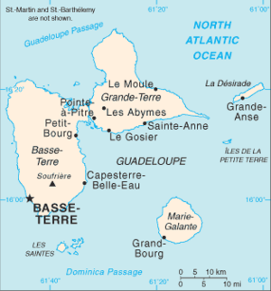
Petite Terre Islands appear about 10 km (6.2 mi) to the south-east of the island of Grande-Terre.

Petite Terre Islands (French: Îles de la Petite Terre, literally "Islands of the Small Land") are two small uninhabited islands located about 10 km (6.2 mi) to the south-east of the island of Grande-Terre in the archipelago of Guadeloupe, itself in the Lesser Antilles. These two islands are named Petite Terre ("Small Land") in contrast with the much larger Grande-Terre ("Large Land") island.

Petite Terre is made up of two islands: Terre de Bas island to the southwest and the smaller Terre de Haut island to the northeast. Their combined land area is 0.48 km² (119 acres).[1] Terre de Bas island (literally "Low Land" island or "Down Land" island) is so named because it is downwind compared to Terre de Haut island ("Upper Land" island) to its northeast which first meets the trade winds blowing from the north-east in the Caribbean.

Administratively speaking, the Petite Terre Islands are part of the commune (municipality) of La Désirade. The two islands and 842 hectares (2,081 acres) of sea around them were declared a nature reserve, the National Nature Reserve of Îles de la Petite-Terre.[1]

References

  1. ^ a b (French) "Îles de la Petite Terre" (html). Les réserves naturelles de France - les réserves. Réserves naturelles de France. http://www.reserves-naturelles.org/reserves/alpha.asp?arbo=1.1&idres=110&rub=0. Retrieved 2010-09-09. [dead link]

External links

Coordinates: 16°10′15″N 61°6′55″W / 16.17083°N 61.11528°W / 16.17083; -61.11528


Wikimedia Foundation. 2010.

Игры ⚽ Нужно сделать НИР?

Look at other dictionaries:

  • Grande-Terre — is also the name of the main island of New Caledonia, and the name of the largest of the Kerguelen Islands.The main part of Guadeloupe consists of two islands separated by a salt river and whose combined shape resembles a butterfly. The western… …   Wikipedia

  • List of islands in the Caribbean — This is a list of islands of the Caribbean region, organized by the political territory each island belongs to.Anguilla* Anguilla * Anguillita * Blowing Rock * Cove Cay * Crocus Cay * Deadman s Cay * Dog Island * East Cay * Little Island * Little …   Wikipedia

  • List of islands of France — This is a list of islands of metropolitan France and French oversea islands.Ranking of French islands By area All French islands over 100 km², ranked by decreasing area. By population List of the most populated French islands.Islands of… …   Wikipedia

  • Comoro Islands — Native name: Komori :جزر القمر (Arabic) Archipel des Comores (French) Geography …   Wikipedia

  • Falkland Islands — Îles Malouines 52°00′00″S 59°30′00″O / 52, 59.5 …   Wikipédia en Français

  • Torres Strait Islands — Îles du Détroit de Torrès 9°52′49″S 142°35′26″E / 9.88028, 142.59056 …   Wikipédia en Français

  • List of islands in Chagos Archipelago — List of Islands in Chagos Archipelago#Île Aigle, Eagle Islands #Ile Anglaise #Ile Anglaise #Ile Aux Vaches #Ile Boddam #Île Carpate, Egmont Islands (Île Carre Pate) #Ile Charles #Grande Ile Coquillage #Petite Ile Coquillage #Île Cipaye, Egmont… …   Wikipedia

  • Burnt Islands (Terre-Neuve-et-Labrador) — 47° 35′ 50″ N 58° 53′ 08″ W / 47.5973, 58.8855 …   Wikipédia en Français

  • Change Islands — 49° 40′ 19″ N 54° 24′ 28″ W / 49.67194, 54.40790 …   Wikipédia en Français

  • Mascarene Islands — Native name: Mascareignes Topographic map of Mascarene Islands …   Wikipedia

Share the article and excerpts

Direct link
Do a right-click on the link above
and select “Copy Link”