- Cavendish, Prince Edward Island
Infobox Settlement
official_name = Cavendish
nickname =
settlement_type = unincorporated rural area
motto =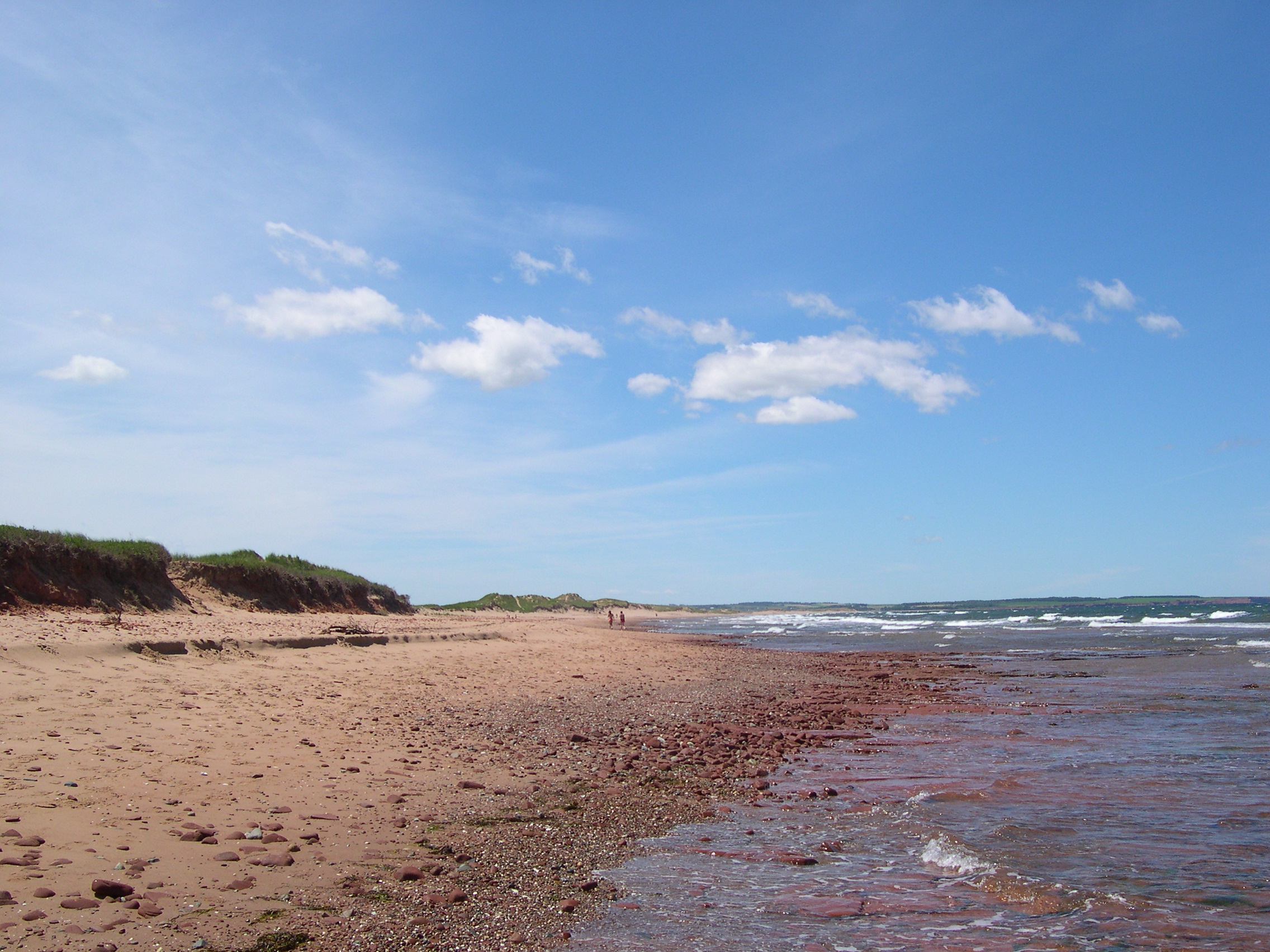
imagesize = 250px
image_caption = Cavendish Beach in Prince Edward Island National Park
image_
mapsize =
map_caption =
pushpin_
pushpin_label_position = none
pushpin_map_caption =Cavendish in Prince Edward Island
pushpin_mapsize = 220
latd= 46.49127
longd= -63.37867
subdivision_type = Country
subdivision_name =Canada
subdivision_type1 = Province
subdivision_name1 =Prince Edward Island
|subdivision_type2 =County
subdivision_name2 = Queens County
subdivision_type3 = Parish
subdivision_name3 = Greensville
subdivision_type4 = Lot
subdivision_name4 = Lot 23
government_type =
leader_title =
leader_name =
leader_title1 =
leader_name1 =
leader_title2 =
leader_name2 =
leader_title3 =
leader_name3 =
leader_title4 =
leader_name4 =
established_title = Founded
established_date = circa 1790
established_title2 = unincorporated Village
established_date2 =
established_title3 = UnincorporatedRural Area
established_date3 = 1990
area_magnitude =
area_total_km2 =
area_total_sq_mi =
population_as_of = 2001
population_footnotes =
population_note =
population_total = 267
population_metro =
population_urban =
population_density_km2 =
population_density_sq_mi =
timezone = Atlantic (AST)
utc_offset =
timezone_DST =
utc_offset_DST =
elevation_m =
elevation_ft =
website =
postal_code_type = Canadian Postal code
postal_code = C0A 1N0
area_code = 902
blank_name = NTS Map
blank_info = 011L06
blank1_name = GNBC Code
blank1_info = BAAQT
footnotes = Cavendish (2006 pop.: 272) is a Canadian unincorporated rural area in the township of Lot 23, Queens County,Prince Edward Island . Its primary industries are tourism and agriculture.Geography
Located northwest of North Rustico and east of Stanley Bridge in the central part of the province on the north shore, fronting the
Gulf of St. Lawrence .History
Lacking a harbour, Cavendish was primarily a small farming community throughout the 19th and first half of the 20th centuries.
Cavendish traces its name to Field Marshal
Lord Frederick Cavendish , aColonel of the34th Regiment of Foot (the Cumberland) . It was likely given by local resident William Winter, an ex-British Army officer, who named the community in honour of his patron.Author
Lucy Maude Montgomery was raised in nearby New London during the lateVictorian era , with Cavendish being the home of her maternal grandparents, who had a house and small farm immediately east of the Cavendish United Presbyterian Cemetery at the intersection of the Cavendish Road and Cawnpore Lane. Montgomery would also frequently visit her cousins' the MacNeill family, who owned a farm namedGreen Gables located west of the intersection. She would later find work in the community with the federal Post Office Department as apostmaster at the Cavendish Post Office. Montgomery's experiences in the community formed a strong impression on her and she would later include much of her experiences in this part of rural Prince Edward Island at the turn of the 20th century in the literary blockbuster "Anne of Green Gables " and subsequent works.Prior to Montgomery's writings, Cavendish's primary claim to fame came on July 22, 1883 when the 3-masted world-record holding
clipper ship "Marco Polo" grounded and broke apart on Cavendish Beach.Following the critical acclaim of Montgomery's writing, as well as coincident with the increase in vehicle-based tourism throughout North America during the first half of the century, Cavendish began to evolve into primarily a resort community.
In 1937, the
Prince Edward Island National Park was established along 60 kilometres of the province'sGulf of St. Lawrence shoreline - part of the park expropriation also included the MacNeill family's Green Gables farm. The national park also boasted many of Prince Edward Island's best beaches, of whichCavendish Beach was one of the most popular. To increase the tourist draw to the area, the national park also developed an 18-hole golf course and opened the "Green Gables" farmhouse for tours. The site of Montgomery's childhood home is also a popular tourist destination.Subsequent development between the 1950s-1990s saw motels, campgrounds, amusement parks and other attractions, shopping facilities, and bars and restaurants built. During any given week in July and August, the community's population expands as of tens of thousands of tourists flock to the national park and local attractions.
In 1990 Cavendish became part of the Resort Municipality of Stanley Bridge-Hope River-Bayview-Cavendish-North Rustico.
External links
* [http://www.gov.pe.ca/placefinder/index.php3?city=cavendish Government of PEI Profile]
* [http://www.cavendishbeachresort.com Cavendish Beach Resort]
* [http://ca.epodunk.com/profiles/prince-edward-island/cavendish/2008598.html Epodunk Canada Profile]References
* [http://www12.statcan.ca/english/Profil01/CP01/Details/Page.cfm?Lang=E&Geo1=CSD&Code1=1102045&Geo2=PR&Code2=11&Data=Count&SearchText=Cavendish&SearchType=Begins&SearchPR=01&B1=All&Custom= Cavendish Statistics]
* [http://www.electricscotland.com/history/articles/cavendish.htm Cavendish History at ElectricScotland.com]
* [http://www.peiinfo.ca/forums PEIinfo Forums]
* [http://www.peionline.com PEI Online Tourism Information]

Wikimedia Foundation. 2010.