- Yarra Bank Highway
Infobox Australian Road
road_name = Yarra Bank Highway
route_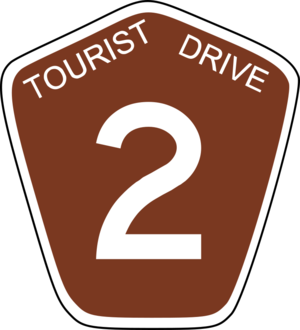
route_
route_
photo =
caption =
length = 2
direction = East-West
start = Batman Avenue /
finish =
est =
through =
route = Yarra River Tourist Route 2
exits = Linlithgow Avenue
Sturt Street
via"' Southbank Boulevard
Yarra Bank Highway is a short convert|2|km|mi|0|lk=on highway in central
Melbourne, Australia . It runs parallel to theYarra River and provides an alternate route to theDomain Tunnel and theBurnley Tunnel onCityLink . It is used by trucks carrying Hazardous Loads prohibited from the tunnels and provides another route when the tunnels are closed for maintenance. Prior to the construction ofCityLink the highway provided the main link between theMonash Freeway and theWest Gate Freeway .The highway travels through a short tunnel underneath St. Kilda Road and The Arts Centre, Melbourne.
Otherwise Known As
There are several locally known street names along the route of the Yarra Bank Highway:
*Power Street (from the
West Gate Freeway to City Road)
*City Road (from Power Street to the St. Kilda Road underpass)
*Alexandra Avenue (from the St. Kilda Road underpass to the Swan Street Bridge)
*Swan Street Bridge (from Alexandra Avenue to the Batman Avenue / Olympic Boulevard intersection)See also
*
List of Melbourne highways


Wikimedia Foundation. 2010.