Magnolia Cemetery (Louisiana)
- Magnolia Cemetery (Louisiana)
Infobox_nrhp
name = Magnolia Cemetery

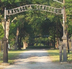
caption = Entrance to Magnolia Cemetery
locator_x =
locator_y =
location = Baton Rouge, Louisiana USA
lat_degrees =
lat_minutes =
lat_seconds =
lat_direction =
long_degrees =
long_minutes =
long_seconds =
long_direction =
area = 10 acres
architect =
architecture =
built = 1852
added = 1985
refnum =85000161
visitation_num =
visitation_year =
governing_body = Foundation for Historic Louisiana
Magnolia Cemetery is a ten acre cemetery in Baton Rouge, Louisiana. The cemetery is located at 422 North 19th Street and is bordered on the north by Main Street and on the south by Florida Boulevard. The west and east sides are bordered by 19th Street and 22nd Street, respectively. The land for the cemetery was purchased from John Christian Buhler, Jr, in August 1852. The cemetery was the site of intense fighting during the Battle of Baton Rouge on August 5, 1862; a commemorative ceremony is held at the cemetery each August. It was turned over to the city of Baton Rouge in 1947 and is now administered by the Recreation and Park Commission for the Parish of East Baton Rouge (BREC).
Famous people buried
This cemetery was the main burial site for most prominent citizens of Baton Rouge, white and African-American, from 1852 to the 1950s and burials continue to the present. Among the more noteworthy persons buried here are 6th District Congressman Edward White Robertson (1823-1887) and his son Congressman Samuel Matthews Robertson (1852-1911), 5th District Congressman William Brainerd Spencer (1835-1882), novelist Lyle Saxon, the Whig politician James M. Elam and his son James Essex Elam, four-time Mayor of Baton Rouge.
ee also
*Baton Rouge National Cemetery
External links
* [http://www.brec.org/index.cfm?md=pagebuilder&tmp=home&cpid=469 BREC Magnolia Cemetery page]
* [http://www.fhl.org/FHL/Stewardship/cemeteries.shtm#magnoliacem Historic Magnolia Cemetery]
Wikimedia Foundation.
2010.
Look at other dictionaries:
Magnolia Cemetery — bezeichnet mehrere gleichnamige, im NRHP gelistete, Objekte: Magnolia Cemetery (Louisiana), ID Nr. 85000161 Magnolia Cemetery (Charleston County, South Carolina), ID Nr. 78002502 Magnolia Cemetery (Darlington County, South Carolina), ID Nr.… … Deutsch Wikipedia
Magnolia Cemetery (Baton Rouge, Louisiana) — Magnolia Cemetery U.S. National Register of Historic Places … Wikipedia
Magnolia Cemetery — is the name of at least eight cemeteries in the United States: Magnolia Cemetery (Mobile, Alabama), listed on the NRHP in Alabama, also known as Magnolia Cemetery including Mobile National Cemetery Magnolia Cemetery (Georgia), in Georgia Magnolia … Wikipedia
Magnolia Cemetery (Mobile, Alabama) — Magnolia Cemetery including Mobile National Cemetery U.S. National Register of Historic Places … Wikipedia
Magnolia Shorty — Birth name Renetta Yemika Lowe Also known as Magnolia $horty Born September 30, 1982(1982 09 30) New Orleans, Louisiana, U.S. Died December 20, 2010 … Wikipedia
Mobile National Cemetery — Magnolia Cemetery including Mobile National Cemetery U.S. National Register of Historic Places … Wikipedia
National Register of Historic Places listings in East Baton Rouge Parish, Louisiana — Location of East Baton Rouge Parish in Louisiana This is a list of the National Register of Historic Places listings in East Baton Rouge Parish, Louisiana. This is intended to be a complete list of the properties and districts on the National… … Wikipedia
Catholic Cemetery (Mobile, Alabama) — Stone Street Cemetery U.S. National Register of Historic Places … Wikipedia
National Register of Historic Places listings in Orleans Parish, Louisiana — Location of Orleans Parish in Louisiana This is a list of the National Register of Historic Places listings in Orleans Parish, Louisiana. This is intended to be a complete list of the properties and districts on the National Register of Historic… … Wikipedia
Natchitoches, Louisiana — Coordinates: 31°44′35″N 93°05′42″W / 31.74306°N 93.095°W / 31.74306; 93.095 … Wikipedia

