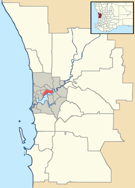
- Mount Helena, Western Australia
-
Mount Helena
Perth, Western AustraliaPopulation: 2419 (2006 census)[1] Postcode: 6082 LGA: Shire of Mundaring State District: Darling Range Federal Division: Pearce Suburbs around Mount Helena: Gidgegannup Stoneville Mount Helena Chidlow Mundaring Sawyers Valley Sawyers Valley Coordinates: 31°52′30″S 116°12′29″E / 31.875°S 116.208°E
Mount Helena is a rural suburb on the outskirts of Perth in Western Australia, some 35 km from the city, in the Shire of Mundaring. Its population in 2005 was approximately 2,400 people.
Contents
History
The suburb was known as Lion Mill until it was renamed Mount Helena in 1924. The chief instigators in the hunt for a new name were the local Progress Association whose first choice, "Hillcrest" had been rejected by the authorities because of a duplication in New South Wales. The next suggestion, "Mount Helena" was more successful, indicative of the terrain and because the suburb was situated centrally in the Helena District.
Geography
The area is hilly and largely covered by bushland, left to naturally re-vegetate since it was milled for building timber and railway sleepers. The township now has many new homes and the bush is now retreating as a consequence. The old railway line embankments for the 2nd Perth to Goldfields railway alignment(made of mainly sand) can still be seen in the town (they are cycle/walking/horse trails now), but the old railway station site has been bulldozed for a new road alignment (Sawyers Rd). The current alignment of the road cuts through the area where the goods shed and eastern end of the platform once stood. The house just to the southwest of the intersection of Sayers Rd and Johnston St is the old station masters house, and is itself a re-purposed wood mill barracks building. An older 1st Goldfields railway alignment embankment has been removed entirely, however it was located where 'Pioneer Park' now stands and ran roughly north east, starting approx 50 metres south of the south eastern end of the Mt Helena hotel (as it was in 1973). The first railway alignment was used for a line that ran from Sawyers Valley, across the main town ship valley (nearly 60 degrees to the still standing railway embankment behind the hotel), and into an cutting (just north of George St) before running parallel to , and about 100metres south of, Keane St. Both of these old railway alignments meet near the Primary School. The old railway cutting running roughly north/south and approx 100metres to the south of the hotel was made by the wood mill company, the railway alignment further west of this cutting was the old Sawyers valley - Mount Helena - Chidlows Well part of the first Goldfields railway line. The Stoneville - Mount Helena - Chidlows railway line was part of the second Goldfields railway alignment. The timber mill was located where the current football fields are located. Remnants of a railway alignment once ran just to the west of the oval and ran north/south down to Keane St before it disappeared. Bauxite was mined from the area just south (approx 500metres) of the township on either side of Sawyers Rd(Approx 1972-1976 time period). The land was rehabilitated but the scars are still easily discernible. There are 10-20acre farmable dells in the area with milking cattle being the main use. Most of the rest of the land is a hard clay and round pebbles known locally as 'gravel'. Under this shallow gravel layer (in many places it is only a metre or so down) is a hard granite layer that is the base rock of the hills district. The Goldfields water supply pipeline runs in a sweeping curve just to the south east ( approx 400metres) of the township centre and from there basically runs between the two old Mount Helena - Chidlows railway alignments (very close to the first alignment) up to the Primary School, from where it runs parallel to the railway alignment and Elliott Road up to the first pumping station (of the original seven) of the Goldfields Water Supply system.
Local activities
Mount Helena boasts several active community and sporting groups, including the Mount Helena Voluntary Bush Fire Brigade, a group of volunteers who tackle bush and house fires in the area.
References
- ^ Australian Bureau of Statistics (25 October 2007). "Mount Helena (State Suburb)". 2006 Census QuickStats. http://www.censusdata.abs.gov.au/ABSNavigation/prenav/LocationSearch?collection=Census&period=2006&areacode=SSC54881&producttype=QuickStats&breadcrumb=PL&action=401. Retrieved 2008-10-05.
- Elliot, Ian (1983). Mundaring - A History of the Shire (2nd ed. ed.). Mundaring: Mundaring Shire. ISBN 0-9592776-0-9.
- Spillman, Ken (2003). Life was meant to be here: community and local government in the Shire of Mundaring. Mundaring: Mundaring Shire. ISBN 0-9592776-3-3.
External links
Suburbs of the Shire of Mundaring | Perth | Western Australia Bailup · Bellevue · Beechina · Boya · Chidlow · Darlington · Glen Forrest · Greenmount · Helena Valley · Hovea · Mahogany Creek · Midvale · Mount Helena · Mundaring · Parkerville · Sawyers Valley · Stoneville · Swan View · The Lakes · Wooroloo
Categories:- Suburbs of Perth, Western Australia
Wikimedia Foundation. 2010.

