Michigan River

Michigan River
Michigan River[1]

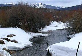
The Michigan River from SH 14 near Gould
Origin Michigan Lakes
40°29′03″N 105°52′45″W / 40.48417°N 105.87917°W / 40.48417; -105.87917
Mouth Confluence with North Platte
40°52′37″N 106°20′22″W / 40.87694°N 106.33944°W / 40.87694; -106.33944Coordinates: 40°52′37″N 106°20′22″W / 40.87694°N 106.33944°W / 40.87694; -106.33944
Progression North PlattePlatte
MissouriMississippi
Length 69 mi (111 km)
Source elevation 11,208 ft (3,416 m)
Mouth elevation 7,864 ft (2,397 m)

The Michigan River is a tributary of the North Platte River, approximately 69 miles (111 km) long,[2] in north central Colorado in the United States. It drains a rural part of the eastern side of North Park in eastern Jackson County. The river issues from Michigan Lakes, a chain of alpine lakes at 11,208 ft (3,416 m), along the continental divide in southeast Jackson County just east of Nokhu Craigs. It descends north then west to flow past the south end of Cameron Pass, and descends from the pass along the route of State Highway 14, past Gould, then northwest through the ranch country of North Park, where it becomes a largely braided stream with a wide river bottom. It passes just east of Walden, and receives the Illinois River from the south just north of Walden. It joins the North Platte from the south approximately 5 miles (8 km) downstream to the north.

See also

References

  1. ^ "Michigan River". Geographic Names Information System, U.S. Geological Survey. http://geonames.usgs.gov/pls/gnispublic/f?p=gnispq:3:::NO::P3_FID:172408. Retrieved 2011-01-31. 
  2. ^ U.S. Geological Survey. National Hydrography Dataset high-resolution flowline data. The National Map, accessed March 21, 2011

External links


Wikimedia Foundation. 2010.

Игры ⚽ Нужна курсовая?

Look at other dictionaries:

  • River Oaks Elementary School — There are several schools named River Oaks Elementary School * River Oaks Elementary School (Houston) in Houston, Texas * River Oaks Elementary School in Austin, Texas * River Oaks Elementary School in Galt, California * River Oaks Elementary… …   Wikipedia

  • Michigan Avenue Bridge — viewed from the west Official name DuSable Bridge Carries Motor vehicles, pedestrians …   Wikipedia

  • Michigan Avenue (Chicago) — Michigan Avenue 100 East South end: 12628 South North end: 950 North Michigan Avenue is a major north south street in Chicago which runs at 100 east (except for one private block that runs at 125 east) south of the Chicago River and at… …   Wikipedia

  • Michigan Central Railroad — (red) and New York Central system (orange) as of 1918 Locale Illinois, Ind …   Wikipedia

  • Michigan Road — Michigan Road, as well as other early roads, in Indiana The Michigan Road was one of the earliest roads in Indiana. Roads in early Indiana were often roads in name only. In actuality they were sometimes little more than crude paths following old… …   Wikipedia

  • Michigan Central Railway Tunnel — Postcard picture, early 1900s Carries 2 tracks of the Canadian Pacific Railway Crosses Detro …   Wikipedia

  • Michigan's Adventure — Location Muskegon, Michigan, U.S. Coordinates …   Wikipedia

  • Michigan State University College of Law — Parent school Michigan State University Established 1891 School type Independent, non profit corporation Parent endowment US $1.449 billion …   Wikipedia

  • Michigan Central Railway Tunnel — Detroiter Tunneleinfahrt in Richtung Ontario 1911 Nutzung Eisen …   Deutsch Wikipedia

  • Michigan Islands National Wildlife Refuge — IUCN Category Ib (Wilderness Area) Location Lake Michigan: Gull, Hat, Pismire, and Shoe islands Lake Huron …   Wikipedia

Share the article and excerpts

Direct link
Do a right-click on the link above
and select “Copy Link”