Minto Reef

Minto Reef
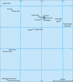
Map of Pohnpei State (with Oroluk Atoll)

Minto Reef is a largely submerged atoll belonging to Pohnpei State in Micronesia.

Description

Minto Reef encloses a lagoon of about 25 to 30 km² in area. There are several boat passages into the lagoon on the southern side. It is at the same time the westernmost and northernmost feature of Pohnpei State. The nearest land is Oroluk Atoll 93 km to the southeast. Close to the northern extremity of the atoll there is a sandbank, about 1.8 meters high.

Minto Reef is the site of Minto Reef Marina Area of Biodiversity Significance, with a total area of 4,204.2 ha.[1]

Administration

Minto Reef is part of Oroluk municipality, along with Oroluk Atoll. The State of Pohnpei in 1999 created the Minto Reef Marine Sanctuary.[2]

References

Coordinates: 8°10′N 154°20′E / 8.167°N 154.333°E / 8.167; 154.333


Wikimedia Foundation. 2010.

Игры ⚽ Поможем написать реферат

Look at other dictionaries:

  • Minto Reef — NASA Satellitenbild Gewässer Pazifischer Ozean Archipel Karolinen …   Deutsch Wikipedia

  • Minto — may refer to the following: Contents 1 Places 2 People 3 Other 4 …   Wikipedia

  • Minto — steht für: Minto (Schottland), einen Ort in Schottland Minto (New South Wales), einen Vorort von Sydney, Australien Minto (New Brunswick), einen Ort in New Brunswick, Kanada Minto (Ontario), einen Ort in Ontario, Kanada Minto (Yukon), einen Ort… …   Deutsch Wikipedia

  • Oroluk (Atoll) — Vorlage:Infobox Insel/Wartung/Höhe fehlt Oroluk Atoll Karte des Oroluk Atolls Gewässer Pazifischer Ozean Archipel …   Deutsch Wikipedia

  • Oroluk — Map of Pohnpei State Oroluk is one of the administrative divisions of Pohnpei State, Federated States of Micronesia.[1] Description Oroluk municipality includes Oroluk Atoll and Minto Reef. This municipality is almost uninhabite …   Wikipedia

  • Pohnpei — Not to be confused with Pompeii, the ancient city destroyed by Vesuvius in AD 79. Kolonia Town looking down from Sokehs Ridge …   Wikipedia

  • Liste der Inseln der Föderierten Staaten von Mikronesien — Karte der Föderierten Staaten von Mikronesien Die Liste der Inseln der Föderierten Staaten von Mikronesien listet alle Inseln, Inselgruppen und Atolle diese Inselstaates auf, geordnet alphabetisch nach Bundesstaat. Alle Inseln und Atolle gehören… …   Deutsch Wikipedia

  • Oroluk Atoll — Map of Pohnpei State (with Oroluk Atoll) Map of Oroluk Atoll Oroluk Atoll is an …   Wikipedia

  • Kapingamarangi — ISS Bild von Kapingamarangi Gewässer Pazifischer Ozean Archipel …   Deutsch Wikipedia

  • Nukuoro — Vorlage:Infobox Insel/Wartung/Höhe fehlt Nukuoro ISS Bild von Nukuoro Gewässer Pazifischer Ozean Archipel …   Deutsch Wikipedia

Share the article and excerpts

Direct link
Do a right-click on the link above
and select “Copy Link”