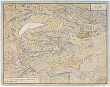
Mongolian manuscript maps
- Mongolian manuscript maps
-
Mongolian manuscript maps usually mapped administrative divisions (leagues, banners or aimags) in Greater Mongolia. They gave a bird's eye view of the area depicted, making them somewhat similar to Pictorial maps. Such manuscript maps have been used for official purposes by the Qing since the 17th century, and new maps continued to be drawn until at least the 1930s.
Although the roots of Mongolian cartography are probably older, the manuscript maps known today were all produced after 1690, when the Lifanyuan in Beijing ordered all Mongolian nobles to produce maps of their territory. Updated maps were to be made every ten years and sent to the Lifanyuan. The maps show major geographic features, and give the positions of those (usually 24 or 48) ovoos that marked the border. The maps normally had Mongolian captions, some were bilingual, others bear small slips of paper with the Chinese translation of the Mongolian names. [1]
Mongolian manuscript maps were first brought to the attention of European scientists by August Strindberg, who in 1878 wrote an article about Dzungarian maps brought to Sweden by Johan Gustaf Renat.[2]
Old Mongolian maps also played a role in the Japanese claims about the western border of Manchuguo in the run-up to the Battle of Khalkhin Gol.
References
- ^ Walther Heissig, Mongolische Landkarten, in Die Mongolen, Innsbruck/ Frankfurt (Main), 1989, p.268ff
- ^ Walther Heissig, Die Mongolen. Ein Volk sucht seine Geschichte, München 1978, p.104ff
Further reading
- Magadbürin Haltod (author)/Walther Heissig (editor), Mongolische Ortsnamen I, Stuttgart 1966
- Walther Heissig (editor), Mongolische Ortsnamen II. Mongolische Manuskriptkarten in Faksimilia, Stuttgart 1978
External links
Wikimedia Foundation.
2010.
Look at other dictionaries:
List of Mongolia-related articles — Articles (arranged alphabetically) related to Mongolia include: Individual administrative districts are listed in Sums of Mongolia. 0 91932 armed uprising (Mongolia) 1990 Mongolian democratic revolutionAAchit Nuur Adasaurus Aero Mongolia Ahmad… … Wikipedia
Западная Монголия — У этого термина существуют и другие значения, см. Монголия (значения). Историческая область • Восточная Азия Западная Монголия … Википедия
literature — /lit euhr euh cheuhr, choor , li treuh /, n. 1. writings in which expression and form, in connection with ideas of permanent and universal interest, are characteristic or essential features, as poetry, novels, history, biography, and essays. 2.… … Universalium
National Library of Australia — Agency overview Formed 1960 Preceding agency Commonwealth Parliamentary Library Jurisdiction Government of Australia Headquarters … Wikipedia
History of cartography — The Fra Mauro map, one of the greatest memorial of medieval cartography, was made around 1450 by the Venetian monk Fra Mauro. It is a circular world map drawn on parchment and set in a wooden frame, about two meters in diameter Cartography (from… … Wikipedia
Turkic peoples — Total population Approximately 160 million[citation needed] Regions with signifi … Wikipedia
New Chronology (Fomenko-Nosovsky) — The New Chronology is a rewriting of world chronology, based on the contention that conventional chronology is fundamentally flawed. The central concepts of the New Chronology are derived from the ideas of Nikolai Morozov,cite… … Wikipedia
Geography and the Church — • Explains the nature of this science and the course of its evolution Catholic Encyclopedia. Kevin Knight. 2006. Geography and the Church Geography and the Church … Catholic encyclopedia
List of Chinese inventions — A bronze Chinese crossbow mechanism with a buttplate (the wooden components have … Wikipedia
Chinese astronomy — The Dunhuang map from the Tang Dynasty (North Polar region). This map is thought to date from the reign of Emperor Zhongzong of Tang (705–710). Founded in Dunhuang, Gansu. Constellations of the three schools were distinguished with different… … Wikipedia

