- Mount Linn
-
Mount Linn 
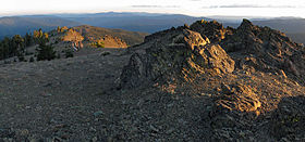
Sunrise Looking NorthwestElevation 8,094 ft (2,467 m) [1] Prominence 4,814 ft (1,467 m) [1] Location Location Tehama County, California, USA Range South Yolla Bolly Mountains Coordinates 40°02′13″N 122°51′18″W / 40.0368197°N 122.8550076°WCoordinates: 40°02′13″N 122°51′18″W / 40.0368197°N 122.8550076°W[2] Topo map USGS South Yolla Bolla Mountains Mount Linn, at 8,094-foot (2,467 m), is the easternmost summit on South Yolla Bolly Mountain, and is located in the Northern Coast Ranges of California in the Yolla Bolly-Middle Eel Wilderness. The summit is the highest point in the Northern Coast Ranges south of the Trinity Alps of the Klamath Mountains.[1] The elevation of the mountain allows it to receive heavy winter snowfall and it has low average annual temperature near the summit.[3]
A tarn named Square Lake is located in a cirques on Mount Linn's north slope.[4] The cirques was carved by glaciers during the Ice Age.
The mountain was named by John C. Frémont in honor of Lewis F. Linn, a senator from Missouri, who played an important roll in the acquisition of the Oregon Territory.[5]
References
- ^ a b c "South Yolla Bolly Mountain, California". Peakbagger.com. http://www.peakbagger.com/peak.aspx?pid=1166. Retrieved 2009-02-01.
- ^ "Mount Linn". Geographic Names Information System, U.S. Geological Survey. http://geonames.usgs.gov/pls/gnispublic/f?p=gnispq:3:::NO::P3_FID:227166. Retrieved 2009-02-01.
- ^ "Subsection M261Ba - Eastern Franciscan". U.S. Forest Service. http://www.fs.fed.us/r5/projects/ecoregions/m261ba.htm. Retrieved 2009-08-13.
- ^ USGS. South Yolla Bolly quadrangle, California (Map). 1:24000. 7.5 Minute Topographic. http://www.topoquest.com/map.php?lat=40.04288&lon=-122.85940&datum=nad83&zoom=2&map=auto&coord=d&mode=zoomin&size=m. Retrieved 2009-08-12.
- ^ Gudde, Erwin G. (1949). California Place Names. Berkeley: Univ. of California Press. p. 188.
External links
- "Foxtail Pine on Mount Linn in the Yolla Bolly-Middle Eel Wilderness". Conifer Country. http://blog.conifercountry.com/2009/08/10/foxtail-pine-on-mount-linn-in-the-yolla-bollymiddle-eel-wilderness.aspx. Retrieved 2009-08-13.
- "Yolla Bolly-Middle Eel Wilderness". Wilderness.net.
- "South Yolla Bolly hike including Mount Linn". Chico Hiking Association. http://chicohiking.org/Individual-Hike-Pages/High-Country/South-Yolly-Bolly.htm. Retrieved 2011-10-31.
Categories:- Mountains of Tehama County, California
- Shasta Cascade geography stubs
Wikimedia Foundation. 2010.
