- Elos
-
For other uses, see Elos (disambiguation).
Elos
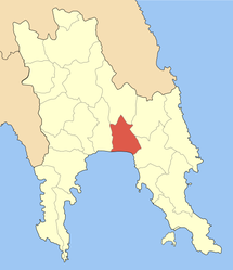
ΈλοςLocation Coordinates 36°50′N 22°42′E / 36.833°N 22.7°ECoordinates: 36°50′N 22°42′E / 36.833°N 22.7°E Government Country: Greece Region: Peloponnese Regional unit: Laconia Municipality: Evrotas Population statistics (as of 2001) Municipal unit - Population: 6,452 Other Time zone: EET/EEST (UTC+2/3) Elevation (center): 15 m (49 ft) Postal: 230 55 Telephone: 27350 Auto: ΑΚ Elos (Greek: Έλος) is a village and a former municipality in Laconia, Peloponnese, Greece. Since the 2011 local government reform it is part of the municipality Evrotas, of which it is a municipal unit.[1] It was called Durali until 1912. The population of the village is 920 people as of 2001[update]. The municipal unit has 6,452 inhabitants. The seat of the municipality was in Vlachioti. The inhabitants work as farmers producing oranges and olive oil. The municipal unit has a coastline on the Laconian Gulf. The Evrotas River is west of Elos. The name dates back to ancient times. It is located W of Monemvasia, E of Gytheio and SE of Sparta.
Contents
Mythology
Pausanias (geographer) mentions a seaside city near Sparta called Helos, whose inhabitants were enslaved and became the helots[2]. Helos was founded by Helios, the younger son of Perseus[2]. The city was reduced by siege by the dorians, and their inhabitants became the first slaves of the of the Lacedemonian state[2].
Other
Elos has a school, a lyceum, a post office, and a square (plateia).
Historical population
Year Municipal district Municipality 1981 756 - 1991 824 5,992 2001 920 6,452 References
- ^ Kallikratis law Greece Ministry of Interior (Greek)
- ^ a b c Description of Greece, 3.20.6, by Pausanias (geographer)
See also
- Communities of Laconia
Categories:- Populated places in Laconia
- Peloponnese geography stubs
Wikimedia Foundation. 2010.


