- Spencer Municipal Airport
-
Spencer Municipal Airport
Northwest Iowa Regional Airport
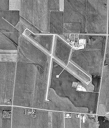
USGS aerial image, 10 April 1991 IATA: SPW – ICAO: KSPW – FAA LID: SPW Summary Airport type Public Owner City of Spencer Serves Spencer, Iowa Location Riverton Township, Clay County Elevation AMSL 1,339 ft / 408 m Coordinates 43°09′56″N 095°12′10″W / 43.16556°N 95.20278°W Website Runways Direction Length Surface ft m 12/30 6,000 1,829 Concrete 18/36 5,100 1,554 Concrete Statistics (2007) Aircraft operations 15,300 Based aircraft 36 Source: FAA,[1] airport website[2] Spencer Municipal Airport[1] (IATA: SPW, ICAO: KSPW, FAA LID: SPW), also known as Northwest Iowa Regional Airport,[2] is a public airport located three miles (5 km) northwest of the central business district of Spencer, a city in Clay County, Iowa, United States. It is owned by the City of Spencer.[1]
The airport is not served by any commercial airlines at this time but it was once the home of Great Lakes Airlines. The airline was named after the nearby Iowa Great Lakes. The airline has since relocated to Cheyenne, Wyoming.
Contents
History
Opened in March, 1942. Provided contract glider training to the United States Army Air Forces, 1942-1944. Training provided by Hunter Flying Service. An all-way turf airfield with a 4,000' x 4,000' landing/takeoff area. Used primarily C-47 Skytrains and Waco CG-4 unpowered Gliders. The mission of the school was to train glider pilot students in proficiency in operation of gliders in various types of towed and soaring flight, both day and night, and in servicing of gliders in the field.
Inactivated during 1944 with the drawdown of AAFTC's pilot training program. Declared surplus and turned over to the Army Corps of Engineers on 30 September 1945. Eventually discharged to the War Assets Administration (WAA) and became a civil airport.
Facilities and aircraft
Spencer Municipal Airport covers an area of 812 acres (329 ha) which contains two concrete paved runways: 12/30 measuring 6,000 x 100 ft (1,829 x 30 m) and 18/36 measuring 5,100 x 75 ft (1,554 x 23 m).[1]
For the 12-month period ending August 16, 2007, the airport had 15,300 aircraft operations, an average of 42 per day: 75% general aviation, 24% air taxi and 1% military. There are 36 aircraft based at this airport: 78% single-engine, 14% multi-engine, 6% ultralight and 2% jet.[1]
See also
References
- ^ a b c d e FAA Airport Master Record for SPW (Form 5010 PDF), effective 2007-10-25
- ^ a b Northwest Iowa Regional Airport page at City of Spencer website
- Other sources
 This article incorporates public domain material from websites or documents of the Air Force Historical Research Agency.
- Shaw, Frederick J. (2004), Locating Air Force Base Sites History's Legacy, Air Force History and Museums Program, United States Air Force, Washington DC, 2004.
- Manning, Thomas A. (2005), History of Air Education and Training Command, 1942-2002. Office of History and Research, Headquarters, AETC, Randolph AFB, Texas ASIN: B000NYX3PC
External links
- FAA Terminal Procedures for SPW, effective 20 October 2011
- Resources for this airport:
- AirNav airport information for KSPW
- ASN accident history for SPW
- FlightAware airport information and live flight tracker
- NOAA/NWS latest weather observations
- SkyVector aeronautical chart, Terminal Procedures for KSPW
Categories:- Airports in Iowa
- Buildings and structures in Clay County, Iowa
- USAAF Contract Flying School Airfields
- USAAF Glider Training Airfields
- Airfields of the United States Army Air Forces in Iowa
- Transportation in Clay County, Iowa
Wikimedia Foundation. 2010.

