- Dalhart Municipal Airport
-
Dalhart Municipal Airport 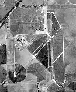
1996 USGS Photo IATA: DHT – ICAO: KDHT – FAA LID: DHT Summary Airport type Public Owner City of Dalhart Location Hartley County, near Dalhart, Texas Elevation AMSL 3,991 ft / 1,216 m Coordinates 36°01′21″N 102°32′50″W / 36.0225°N 102.54722°WCoordinates: 36°01′21″N 102°32′50″W / 36.0225°N 102.54722°W Runways Direction Length Surface ft m 3/21 5,669 1,728 Asphalt 17/35 6,400 1,951 Asphalt Statistics (2007) Aircraft operations 22,750 Based aircraft 36 Source: Federal Aviation Administration[1] 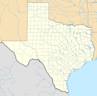
 Dalhart MAPLocation of Dalhart Municipal Airport, Texas
Dalhart Municipal Airport (IATA: DHT, ICAO: KDHT, FAA LID: DHT) is a city-owned public-use airport located three miles (5 km) southwest of the central business district of Dalhart, Texas,[1] a city straddling the border of Dallam and Hartley counties in the northwest corner of the Texas Panhandle.[2]
The airport is not served by any commercial airlines at this time.
Contents
Facilities and aircraft
Dalhart Municipal Airport covers an area of 1,206 acres (488 ha) which contains two asphalt paved runways: 3/21 measuring 5,669 x 75 ft (1,728 x 23 m) and 17/35 measuring 6,400 x 75 ft (1,951 x 23 m).[1]
For the 12-month period ending June 25, 2009, the airport had 22,750 aircraft operations, an average of 62 per day: 75% local general aviation, 25% transient general aviation, and <1% military. There are 30 aircraft based at this airport: 80% single-engine, 17% multi-engine and 3% glider.[1]
History
The airport was constructed by the Army and opened in 1942 as Dalhart Army Air Field. The Army trained B-17 and B-29 pilots at the field during World War II. Known bombardment groups which trained at Dalhart were:
- 6th Bombardment (Very Heavy) (B-29)
- 9th Bombardment (Very Heavy) (B-29)
- 16th Bombardment (Very Heavy) (B-29)
- 331st Bombardment (Very Heavy) (B-29)
- 333d Bombardment (Very Heavy) (B-29)
- 346th Bombardment (Very Heavy) (B-29)
- 382d Bombardment (Heavy) (B-17)
- 383d Bombardment (Heavy) (B-17)
- 415th Bombardment (Dive) (A-20)
- 449th Bombardment (Heavy) (B-17)
- 501st Bombardment (Very Heavy) (B-29)
- 502d Bombardment (Very Heavy) (B-29)
- 504th Bombardment (Very Heavy) (B-29)
- 505th Bombardment (Very Heavy) (B-29)
- 507th Bombardment (Very Heavy) (B-29)
After the war in 1946 it was turned over the city of Dalhart and converted into a municipal airport.
See also
References
 This article incorporates public domain material from websites or documents of the Air Force Historical Research Agency.
- ^ a b c d FAA Airport Master Record for DHT (Form 5010 PDF), effective 2010-11-18
- ^ City of Dalhart, Texas
External links
- Resources for this airport:
- AirNav airport information for KDHT
- ASN accident history for DHT
- FlightAware airport information and live flight tracker
- NOAA/NWS latest weather observations
- SkyVector aeronautical chart, Terminal Procedures for KDHT
 USAAF Second Air Force in World War II
Airfields Group Training Stations · Heavy Bombardment Training Stations · Replacement Training Stations · Tactical Airfields · Very Heavy Bomber Bases
Units Commands II Air Support Command · II Bomber Command · II Fighter Command · IV Air Support Command · XX Bomber Command · XXI Bomber Command · XXII Bomber CommandWings 5th Bombardment · 15th Bombardment Training · 16th Bombardment Operational Training · 17th Bombardment Training · 18th Replacement · 21st Bombardment · 46th Bombardment Operational Training · 58th Bombardment · 73d Bombardment · 315th Bombardment · 316th BombardmentGroups Bombardment 2d Bombardment · 6th Bombardment · 7th Bombardment · 9th Bombardment · 12th Bombardment · 16th Bombardment · 17th Bombardment · 19th Bombardment · 25th Bombardment · 29th Bombardment · 34th Bombardment · 39th Bombardment · 40th Bombardment · 42d Bombardment · 46th Bombardment · 47th Bombardment · 48th Bombardment · 85th Bombardment · 86th Bombardment · 86th Bombardment · 88th Bombardment · 94th Bombardment · 95th Bombardment · 96th Bombardment · 99th Bombardment · 100th Bombardment · 301st Bombardment · 302d Bombardment · 303d Bombardment · 304th Bombardment · 305th Bombardment · 306th Bombardment · 307th Bombardment · 308th Bombardment · 312th Bombardment · 330th Bombardment · 331st Bombardment · 333d Bombardment · 346th Bombardment · 351st Bombardment · 376th Bombardment · 379th Bombardment · 381st Bombardment · 382d Bombardment · 383d Bombardment · 384th Bombardment · 385th Bombardment · 388th Bombardment · 390th Bombardment · 393d Bombardment · 395th Bombardment · 396th Bombardment · 398th Bombardment · 399th Bombardment · 400th Bombardment · 401st Bombardment · 407th Bombardment · 415th Bombardment · 418th Bombardment · 444th Bombardment · 445th Bombardment · 446th Bombardment · 447th Bombardment · 448th Bombardment · 449th Bombardment · 450th Bombardment · 451st Bombardment · 452d Bombardment · 453d Bombardment · 454th Bombardment · 455th Bombardment · 456th Bombardment · 457th Bombardment · 458th Bombardment · 459th Bombardment · 460th Bombardment · 461st Bombardment · 462d Bombardment · 464th Bombardment · 467th Bombardment · 468th Bombardment · 469th Bombardment · 470th Bombardment · 471st Bombardment · 472d Bombardment · 484th Bombardment · 485th Bombardment · 486th Bombardment · 487th Bombardment · 488th Bombardment · 489th Bombardment · 490th Bombardment · 491st Bombardment · 493d Bombardment · 494th Bombardment · 497th Bombardment · 498th Bombardment · 499th Bombardment · 500th Bombardment · 501st Bombardment · 502d Bombardment · 504th Bombardment · 505th Bombardment · 509th CompositeFighter Reconnaissance 2d Reconnaissance · 3d Reconnaissance · 4th Reconnaissance · 5th Reconnaissance · 6th Reconnaissance · 7th Reconnaissance · 8th Reconnaissance · 71st Reconnaissance · 77th ReconnaissanceTroop Carrier 443d Troop CarrierCategories:- 1943 establishments
- USAAF Second Air Force Heavy Bombardment Training Stations
- Airfields of the United States Army Air Forces in Texas
- Airports in Texas
- Buildings and structures in Hartley County, Texas
- Transportation in Hartley County, Texas
- Texas airport stubs
- Texas building and structure stubs


Wikimedia Foundation. 2010.