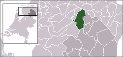
- Noordenveld
-
Noordenveld — Municipality — 
Flag
Coat of armsCoordinates: 53°7′N 6°26′E / 53.117°N 6.433°ECoordinates: 53°7′N 6°26′E / 53.117°N 6.433°E Country Netherlands Province Drenthe Area(2006) - Total 205.36 km2 (79.3 sq mi) - Land 201.22 km2 (77.7 sq mi) - Water 4.14 km2 (1.6 sq mi) Population (1 January, 2007) - Total 31,362 - Density 156/km2 (404/sq mi) Source: CBS, Statline. Time zone CET (UTC+1) - Summer (DST) CEST (UTC+2) Noordenveld (
 pronunciation (help·info)) is a municipality in the northeastern Netherlands.
Population centres
Altena, Alteveer, Amerika, Boerelaan, De Horst, De Pol, Een, Een-West, Foxwolde, Huis ter Heide, Langelo, Leutingewolde, Lieveren, Matsloot, Nietap, Nieuw-Roden, Norg, Norgervaart, Peest, Peize, Peizermade, Peizerwold, Roden, Roderesch, Roderwolde, Sandebuur, Steenbergen, Terheijl, Veenhuizen, Westervelde and Zuidvelde.
External links
- Official website
- wikia:Peize:Hoofdpagina - wiki about Peize, in the Wikia family
Aa en Hunze · Assen · Borger-Odoorn · Coevorden · De Wolden · Emmen · Hoogeveen · Meppel · Midden-Drenthe · Noordenveld · Tynaarlo · Westerveld

See also: Netherlands · Provinces · Municipalities Categories:- Municipalities of Drenthe
- Drenthe geography stubs
Wikimedia Foundation. 2010.

