- De Wolden
-
De Wolden — Municipality — 
Flag
Coat of arms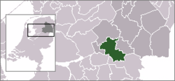
Coordinates: 52°45′0″N 6°21′0″E / 52.75°N 6.35°ECoordinates: 52°45′0″N 6°21′0″E / 52.75°N 6.35°E Country Netherlands Province Drenthe Area(2006) - Total 226.35 km2 (87.4 sq mi) - Land 224.78 km2 (86.8 sq mi) - Water 1.57 km2 (0.6 sq mi) Population (1 January 2007) - Total 23,593 - Density 105/km2 (271.9/sq mi) Source: CBS, Statline. Time zone CET (UTC+1) - Summer (DST) CEST (UTC+2) De Wolden (
 pronunciation (help·info)) is a municipality in the northeastern Netherlands.
Population centres
Alteveer, Anholt, Ansen, Armweide, Bazuin, Benderse, Berghuizen, Blijdenstein, Bloemberg, Braamberg, Buitenhuizen, Bultinge, De Oude Tol, De Stapel, De Stuw, De Tippe, De Wijk, Dijkhuizen, Dickninge, Drogt, Drogteropslagen, Dunnigen, Echten, Eemten, Engeland, Eursinge, Fort, Gijsselte, Haakswold, Haalweide, Hees, Hoge Linthorst, Kerkenveld, Koekange, Koekangerveld, Kraloo, Leeuwte, Linde, Lubbinge, Lunssloten, Middelveen, Nolde, Oldenhave, Oosteinde, Oosterwijk, Oshaar, Oud Veeningen, Paardelanden, Pieperij, Rheebruggen, Ruinen, Ruinerweide, Ruinerwold, Schottershuizen, Schrapveen, Steenbergen, Struikberg, Ten Arlo, Veeningen, Vuile Riete, Weerwille, Wemmenhove, Witteveen and Zuidwolde.
External links
References
Aa en Hunze · Assen · Borger-Odoorn · Coevorden · De Wolden · Emmen · Hoogeveen · Meppel · Midden-Drenthe · Noordenveld · Tynaarlo · Westerveld

See also: Netherlands · Provinces · Municipalities Categories:- Municipalities of Drenthe
- Drenthe geography stubs


Wikimedia Foundation. 2010.