- Dirillo
-
Coordinates: 37°0′N 14°20′E / 37°N 14.333°E
Dirillo 
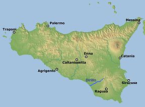
Origin Iblei mountains, near Vizzini Mouth Strait of Sicily, south-east of Gela Basin countries Sicily: provinces of Ragusa, Caltanissetta and Catania Length 54 km (34 mi) Source elevation 986 m (3,235 ft) Mouth elevation 0 m (0 ft) Basin area 739.39 km2 (285.48 sq mi) The Dirillo, or Acate, is a 54 kilometres (34 mi) river in Sicily which springs from the Hyblaean Mountains and flows through the areas of Vizzini, Licodia Eubea, Mazzarrone, Chiaramonte Gulfi, Acate, Vittoria, Gela. It enters the Strait of Sicily south-east of the town of Gela. As the largest river in the area it is sometimes known as the Fiume Grande.
The river was known in antiquity as the Achates. Theophrastus in his treatise On Stones (ca. 315 B.C.) indicates that the name of the gemstone achates (agate) was based on the source of such stones from this river.[1] Pliny the Elder makes the same connection in his Naturalis Historia[2] Agate and chalcedony can still be found here. During the period of Arab rule it became known as Wadi‑Ikrilu: ‘The River of Acrille’, an ancient Greek-Roman colony that stood in the surroundings.
In the 1950s the Azienda Nazionale Idrogenazione Combustibili dammed the river near Licodia Eubea to create Lago Dirillo, a reservoir for the Polo petrolchimico di Gela petrochemical plants. With good fishing and camping facilities, as well its natural scenic beauty, this area has become a tourist attraction.
Footnotes
References
- This article includes material from its counterpart in the Italian-language Wikipedia « it:Dirillo » , specifically from this version.
External links
Categories:- Rivers of Italy
- Rivers of Sicily
- Gela
- Rivers of the Province of Caltanissetta
- Rivers of the Province of Catania
- Rivers of the Province of Ragusa
- Sicily geography stubs
Wikimedia Foundation. 2010.
