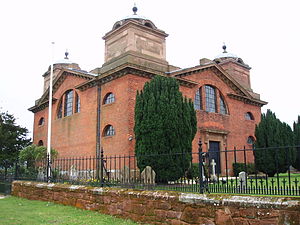
St James' Church, Great Packington
- St James' Church, Great Packington
-

St James Church (photo 2008)
St James' Church is an 18th century chapel situated in the grounds of Packington Hall, near Meriden, Warwickshire. It is a Grade I listed building.
The church was built in 1789 to a design by architect Joseph Bonomi for the Earl of Aylesford as a private family chapel. It is said to commemorate the recovery of George III from insanity.
The red brick church, in neo classical style, has an unusual square plan with four corner turrets topped with domes and finials.
It houses an organ built by Thomas Parker, to specifications outlined by Handel in 1749, for Charles Jennens, a cousin of the 4th Earl, owner of Gopsall Hall. The organ was filmed and recorded for the documentary The Elusive English Organ.
References
Coordinates: 52°27′15″N 1°39′47″W / 52.4542°N 1.6631°W / 52.4542; -1.6631
Categories:
- Grade I listed buildings in Warwickshire
- Grade I listed churches
- Churches in Warwickshire
Wikimedia Foundation.
2010.
Look at other dictionaries:
Great Packington — Packington Park Great Packington is a hamlet near Meriden, Warwickshire. It is the home of the Packington estate, including Packington Hall, Packington Old Hall and St James Church, Great Packington. To the east of the park lies the hamlet of… … Wikipedia
Packington Hall — is a 17th century mansion situated at Great Packington, near Meriden, Warwickshire, England the seat of the Earl of Aylesford. It is a Grade II* listed building.It was built in 1693 for Sir Clement Fisher on whose death in 1729 the Packington… … Wikipedia
James Wyatt — This article refers to the English architect. For the game designer, see James Wyatt (game designer) .:distinguish|James WattJames Wyatt RA (August 3 1746 – September 4 1813), was an English architect, a rival of Robert Adam in the neoclassical… … Wikipedia
A roads in Zone 4 of the Great Britain numbering scheme — The numbering zones for A roads in Great Britain List of A roads in zone 4 in Great Britain starting north of the A4 and south/west of the A5 (roads beginning with 4). Contents … Wikipedia
Gopsall — (or Gopsall Park) is an area of Crown Estate land in North West Leicestershire, England. It is located between the villages of Shackerstone, Twycross and Snarestone.Gopsall is the site of a former Georgian country house that was known as Gopsall… … Wikipedia
Levett — is an Anglo Norman territorial surname deriving from the village of Livet en Ouche, now Jonquerets de Livet, in Eure, Normandy. Ancestors of the the earliest Levett family in England, the de Livets were lords of the village of Livet, [The Norman… … Wikipedia
Diocese of Coventry — Location Ecclesiastical province Canterbury Archdeaconries Warwick, Coventry Statistics Parishes … Wikipedia
List of Acts of Parliament of the English Parliament, 1660 to 1699 — This is a list of Acts of Parliament of the English Parliament during that body s existence prior to the Act of Union of 1707. For legislation passed after that date see List of Acts of Parliament of the United Kingdom Parliament.The numbers… … Wikipedia
Henry Couchman — of Balsall Temple, Warwickshire, an 18th century architect and landscape gardener, designed the Old Draper’s Hall, Coventry (demolished) and helped complete Arbury Hall, Warwickshire, for Sir Roger Newdigate, including designing the magnificent… … Wikipedia
Lichfield — Not to be confused with Litchfield (disambiguation). For other uses, see Lichfield (disambiguation). Coordinates: 52°41′01″N 1°49′36″W / 52.6835°N 1.82653°W … Wikipedia

