Washington State Route 110
- Washington State Route 110
Infobox WA State Route
type=State
route=110
sec=
parent_type=U.S.
parent=101
length_mi=11.10
length_ref=[cite web|author=Washington State Department of Transportation|url=http://www.wsdot.wa.gov/mapsdata/tdo/PDF_and_ZIP_Files/HwyLog2006.pdf|title=State Highway Log, 2006|accessdate=2007-04-22] ]
length_round=2
formed=1992
dir2=West
dir1=East
to=Olympic National Park in La Push
from=
previous_type=WA
previous_route=109
next_type=WA
next_route=112
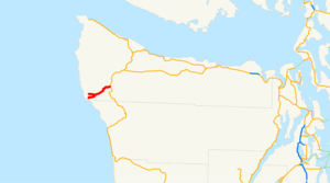
State Route 110 is a state highway in the U.S. state of Washington, running from Forks to La Push. The road is also known as La Push Road.
A spur route, designated SR 110 Spur extends from SR 110 in Mora to the Olympic National Park boundary near the Mora Ranger Station.
History
What is now State Route 110 was originally added to the state highway system in 1937 as State Secondary Highway 9-B, but was removed in 1955. It was added back to the state highway system by the state legislature in 1991, although that law did not take effect until April 1, 1992.
A different route was designated State Route 110 from 1967 to 1975. It is now the portion of State Route 11 from Fairhaven east to Interstate 5.
Major intersections
References
* [http://www.angelfire.com/wa2/hwysofwastate/sr110.html State Route 110 ]
Wikimedia Foundation.
2010.
Look at other dictionaries:
Washington State Route 105 — State Route 105 Route information … Wikipedia
Virginia State Route 110 — Infobox road state=VA type= route=110 alternate name=Jefferson Davis Highway length mi=2.29 length ref=PDFlink| [http://www.virginiadot.org/info/resources/AADT 000 Arlington 2005.pdf 2005 Virginia Department of Transportation Jurisdiction Report… … Wikipedia
Washington State Route 527 — Infobox road state=WA type=SR route=527 alternate name=Bothell ndash; Everett Highway maint= length mi=11.92 length round=2 length ref=cite web |author=Washington State Department of Transportation |url=http://www.wsdot.wa.gov/mapsdata/tdo/PDF… … Wikipedia
Washington State Route 26 — Infobox road state=WA type=SR route=26 maint= length mi=133.61 length round=2 length ref=cite web |author=Washington State Department of Transportation |url=http://www.wsdot.wa.gov/mapsdata/tdo/PDF and ZIP Files/HwyLog2006.pdf |title=State… … Wikipedia
Washington State Route 410 — State Route 410 Chinook Scenic Byway … Wikipedia
Washington State Route 167 — infobox WA State Route type=WA route=167 sec=330 parent=410 parent type=WA alternate name=Valley Freeway length mi=28.60 length ref= length round=2 formed=1964 dir1=South dir2=North from= junction= to= in Renton previous type=WA previous… … Wikipedia
Washington State Route 599 — Infobox road state=WA type=SR route=599 maint= length mi=1.75 length round=2 length ref=cite web |author=Washington State Department of Transportation |url=http://www.wsdot.wa.gov/mapsdata/tdo/PDF and ZIP Files/HwyLog2006.pdf |title=State Highway … Wikipedia
Washington State Route 339 — Infobox road state=WA type=SR route=339 alternate name=Seattle / Vashon Island PO ferry maint= direction a=West terminus a=jct|state=WA|SR|160|city1=Vashon Heights ferry terminal direction b=East terminus b=jct|state=WA|SR|519|city1=Seattle Pier… … Wikipedia
Washington State Route 112 — Infobox WA State Route|route=112|sec=215|length mi=61.29 length ref=cite web|author=Washington State Department of Transportation|url=http://www.wsdot.wa.gov/mapsdata/tdo/PDF and ZIP Files/HwyLog2005B.pdf|title=State Highway Log, 2005… … Wikipedia
Washington State Route 109 — Infobox WA State Route type=State route=109 sec=200 parent type=U.S. parent=101 length mi=40.50 length ref=cite web|author=Washington State Department of Transportation|url=http://www.wsdot.wa.gov/mapsdata/tdo/PDF and ZIP… … Wikipedia
