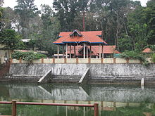
- Cheruvally
-
Cheruvally — village — Coordinates 9°31′19″N 76°46′00″E / 9.5220000°N 76.76669°ECoordinates: 9°31′19″N 76°46′00″E / 9.5220000°N 76.76669°E Country India State Kerala District(s) Kottayam Nearest city Ponkunnam Parliamentary constituency Pathanamthitta Time zone IST (UTC+05:30) Codes-
• Pincode • 686519 • Vehicle • KL-34
Cheruvally is a Village in Kottayam district of kerala. It is in Kanjirappally taluk. Although Cheruvally is vast and covers a large area. Name of the place is derived from the myth related to cheruvally temple. Its developing to a small town now.
History
Cheruvally has its own relevance in the historic and cultural charts of Central Travancore. Formerly this was under the reign of Vanjipuzha Matt, Poonjar.
Categories:- Kottayam district geography stubs
- Villages in Kottayam district
-
Wikimedia Foundation. 2010.


