- Benicia-Martinez Bridge
Infobox_Bridge
bridge_name = Benicia-Martinez Bridge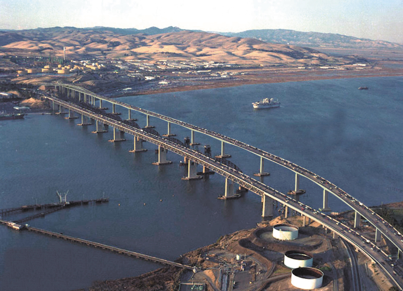
caption = Aerial view of the Benicia-Martinez Bridge. From left to right: Southbound span (1962) Railway (1930) and Northbound span (2007)
official_name =George Miller, Jr. Memorial Bridge [ [http://www.dot.ca.gov/hq/tsip/hseb/products/2006_Named_Freeways.pdf 2006 Named Freeways] ,Caltrans , 2007-01. Retrieved on 2007-09-06.] (southbound span),George Miller III Bridge (northbound span)
also_known_as =
carries = 8 lanes of I-680
crosses =Carquinez Strait
locale =Martinez, California andBenicia, California
maint = Caltrans
id = 28 0153
design =Truss bridge (southbound span),segmental bridge (northbound span)
mainspan = 528 feet (160.93 m) (7 spans)
length = 1.7 miles (2.7 km)
width =
clearance =
below = 138 feet (42.1 m)
traffic =
open =
closed =
toll = $4.00 (northbound) (FasTrak )
map_cue =
map_
map_text =
map_width =
coordinates = coord|38.0406|N|122.1230|W|region:US_type:landmark|display=inline,title|format=dmsThe Benicia-Martinez Bridge refers to three parallel bridges which cross the
Carquinez Strait just west ofSuisun Bay ; the spans linkBenicia, California to the north withMartinez, California to the south. The 1.2 mile (1.9 km) decktruss bridge opened in 1962 as a replacement for the last automotiveferry service in theSan Francisco Bay Area . The 1962 bridge consists of seven convert|528|ft|m|sing=on spans which provide convert|138|ft|m of vertical clearance, carrying three lanes of traffic in the southbound direction. (Planned upgrades will provide four lanes of traffic and a bicycle/pedestrian lane.) A 1.7 miles (2.7 km) bridge was built alongside and opened onAugust 25 ,2007 which carries five lanes of northbound traffic. The cost to construct the 1962 span was US$25 million and US$1.3 billion to build the 2007 span [cite news|url=http://www.timesheraldonline.com//ci_6725729|title=Bay Area's newest bridge is open for business|date=2007-08-26|accessdate=2007-08-27] . The bridge is part of Interstate 680, itself a major transportation link, and connects several other heavily traveled freeways.Between the two vehicle bridges is a railroad bridge owned and operated by the
Union Pacific Railroad . The railroad bridge was the first bridge at this location, built between April 1929 and October 1930 by theSouthern Pacific Railroad . It is used byUnion Pacific and BNSF (trackage rights)freight trains , as well as 36 scheduledAmtrak passenger trains each weekday. Passenger trains include the long-distance trainsCalifornia Zephyr andCoast Starlight as well asCapitol Corridor inter-city commuter trains.The Interstate 680 bridges, i.e. the two automobile spans, are usually referred to simply as "the Benicia Bridge."
Current tolls
The Benicia-Martinez bridge toll plaza is located at the south end of the bridge. Tolls are only charged for northbound traffic. The toll plaza has nine lanes with toll booths and another nine lanes with
open road tolling (ORT) configured in two zones. One ORT zone has two travel lanes and four shoulder lanes. The other ORT zone has one carpool travel lane with two shoulder lanes. This bridge is the first open road tolling facility inNorthern California and the first bridge with open road tolling inCalifornia .Adjacent railroad bridge
A
railroad bridge owned byUnion Pacific Railroad spans the waterway between the two vehicle bridges. The railroad bridge was built bySouthern Pacific Railroad between 1928 and 1930. Prior to the railroad bridge's opening in 1930, the railroad used a ferry between Benicia andPort Costa, California . The ferry, built atOakland, California in 1879 and named the "Solano", was the world's largest train ferry. In 1914, a second ferry named the "Contra Costa" was built. The ferries ended service in 1930 with the completion of the railroad bridge.Northbound span
A newer bridge was constructed east of and parallel to the railroad bridge. It measures approximately 1.7 miles (2.7 km). The new bridge carries five lanes of northbound traffic. The older bridge is undergoing
seismic retrofit s and will carry four lanes of southbound traffic, as well as abicycle /pedestrian lane. The bridge construction also included a new toll plaza with nine toll booths, twoopen road tolling lanes and one carpool lane at the south end of the bridge, although tolls will continue to be charged only for northbound traffic.The new toll plaza was retrofitted for open road tolling in order to encourage increased FasTrak usage. This required the removal of eight toll booths previously constructed.
The bridge is the largest lightweight concrete segmental bridge in
California . The estimated cost of building the bridge was $1.05 billion, the final cost was $1.3 billion. The bridge original estimated cost was around 300 million, it is noted for is large delay in construction and large over cost (over $1 billion). The new bridge opened to public traffic at 10:30pm on August 25, 2007. [cite news|url=http://www.timesheraldonline.com/ci_6719312|title=The Benicia Bridge|publisher=Vallejo Times Herald |date=2007-08-25|accessdate = 2007-08-25] [cite news|url=http://www.mercurynews.com/breakingnews/ci_6719613|title=First cars drive over new Benicia Bridge|publisher=San Jose Mercury News |date=2007-08-25|accessdate=2007-09-03]ee also
*
California Pacific Railroad References
External links
* [http://www.dot.ca.gov/hq/traffops/hwybrdg/tollbridge/History/Benicia.html California Dept. of Transportation: Benicia-Martinez Bridge History & Information]
* [http://www.dot.ca.gov/dist4/benicia/ Caltrans' New Benicia-Martinez Bridge project page]
* [http://www.earthmech.com/benicia%20martinez.htm Earth Mechanics Inc. Benicia bridge project page] - EMI is the geotechnical engineer for the new bridge
* [http://www.contracostatimes.com/mld/cctimes/email/news/11284787.htm Benicia-Martinez Bridge may cost millions more] - Contra Costa Times article about technical difficulties
*
*Crossings navbox
structure = Crossings
place =Carquinez Strait
bridge = Benicia-Martinez Bridge
bridge signs =
upstream =Rio Vista Bridge
(Sacramento River )
----Antioch Bridge
(San Joaquin River )
upstream signs =
downstream =Carquinez Bridge
downstream signs =
Wikimedia Foundation. 2010.