- Ngiri-Ngiri
-
Ngiri-Ngiri
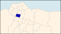
Commune de Ngiri-Ngiri— Commune — Ngiri-Ngiri on a map of Kinshasa communes Kinshasa city-province on a map of the DRC
Coordinates: 4°21′27″S 15°17′54″E / 4.3575°S 15.29833°ECoordinates: 4°21′27″S 15°17′54″E / 4.3575°S 15.29833°E[1] Country Democratic Republic of the Congo Province Kinshasa District Funa Area - Total 3.4 km2 (1.3 sq mi) Population (2004 est.) - Total 174,843 - Density 51,424.4/km2 (133,188.6/sq mi) Ngiri-Ngiri is a municipality (commune) in the Funa district of Kinshasa, the capital city of the Democratic Republic of the Congo.[2]
It is situated in the south of Kinshasa. Ngiri-Ngiri is one of the new settlements, located at the foot of the Kalamu and Kasa-Vubu hills to the south of the province.
Demographics
Historical population of Ngiri-Ngiri 1967 1970 1984 2003 2004 50,930 64,272 82,303 169,087 174,843 References
- ^ "Ngiri Ngiri, Kinshasa, Democratic Republic of the Congo". Google Maps. http://maps.google.com/maps/place?ftid=0x1a6a31268bb28ac7:0x54e221140d799a33. Retrieved 20 August 2011.
- ^ "Géographie de Kinshasa (Geography of Kinshasa)" (in French). Ville de Kinshasa (City of Kinshasa). http://www.kinshasa.cd/index.php?option=com_content&view=article&id=300. Retrieved 20 August 2011.
Communes of the city-province of Kinshasa Bandalungwa · Barumbu · Bumbu · Gombe · Kalamu · Kasa-Vubu · Kimbanseke · Kinshasa (commune) · Kintambo · Kisenso · Lemba · Limete · Lingwala · Makala · Maluku · Masina · Matete · Mont Ngafula · Ndjili · Ngaba · Ngaliema · Ngiri-Ngiri · Nsele · Selembao
 Categories:
- Communes of Kinshasa
- Democratic Republic of the Congo geography stubs
Wikimedia Foundation. 2010.

