- Chukchi Cap
-
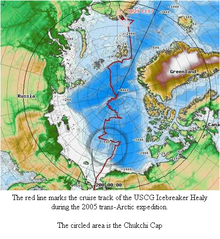 Voyage of the USCGC Healy and the Chukchi cap
The Chukchi Cap is a large undersea ridge in the Arctic Ocean.[1][2] The cap is normally ice-covered, year-round. The United States Coast Guard Cutter Healy has been sent on multiple missions to map the poorly explored ridge.
The cap lies roughly about 800 kilometres north of the Point Barrow, Alaska.[1][2] The area is notable because it is believed to be rich in natural resources (especially oil, natural gas and manganese) and it is in disputed waters.[citation needed]
In 2011, scientists aboard sea vessel, Marcus G. Langseth, ran tests to increase understanding of the geology, structure and history of the continental shelves running underwater off Asia and North America, and the Chukchi Borderland, an adjoining region of dramatic deep-sea plateaus and ridges some 800 miles from the North Pole. One test includes sending sound pulses to the seabed and reading the echoes.[3]
References
- ^ a b National Oceanic & Atmospheric Administration. "United States Explores the Seabed of the Arctic Ocean: to bolster its Claims to the North's Strategic Resources". Canadian American Strategic Review. Archived from the original on 2007-10-24. http://web.archive.org/web/20071024121840/http://www.sfu.ca/casr/id-arctic-empires-3.htm. Retrieved 2007-09-18.
- ^ a b Marie Darling, Donald Perovich. "CRREL scientists complete Arctic voyage of discovery". United States Army Corps of Engineers. Archived from the original on 2007-08-23. http://web.archive.org/web/20070823224750/http://www.hq.usace.army.mil/cepa/pubs/apr06/story17.htm. Retrieved 2007-09-18.
- ^ http://blogs.ei.columbia.edu/2011/09/14/exploring-an-unknown-arctic-seabottom-no-ice-included/

This article about a specific oceanic location or ocean current is a stub. You can help Wikipedia by expanding it.
