- Church Point, Louisiana
-
Town of Church Point Town Country United States State Louisiana Parish Acadia Elevation 46 ft (14 m) Coordinates 30°24′17″N 92°13′01″W / 30.40472°N 92.21694°W Area 2.8 sq mi (7.3 km2) - land 2.8 sq mi (7 km2) - water 0.0 sq mi (0 km2), 0% Population 4,756 (2000) Density 1,726.5 / sq mi (666.6 / km2) Timezone CST (UTC-6) - summer (DST) CDT (UTC-5) Area code 337 
 Location of Church Point in Louisiana
 Location of Louisiana in the United States
Website: http://www.churchpoint-la.com Church Point (French: Pointe-à-l'Église[1]) is a town in Acadia Parish, Louisiana, United States. The population was 4,756 at the 2000 census. It is part of the Crowley Micropolitan Statistical Area.
Contents
History
In the late 18th century, French settlers from Quebec, Canada created clearings by burning the underbrush, leaving what they called "a brûlé". "A brûlé" is a "burn", much as the Native Americans in the area had created a "burn" to promote new grass to attract bison and other grazing and browsing animals.
One of these clearings was created on a slough off of Bayou Mermentau, near where the slough came to a point. This new clearing became known as Plaquemine Brûlé in 1843 when Etienne d'Aigle III, a descendant of immigrants from Quebec, became the first settler in the area, which at that time was in the middle of Opelousas Parish (later St. Landry Parish), which stretched from the Atchafalaya River to the Sabine River.
Plaquemine is an Atakapa word for the native Louisiana persimmon. The French term "Plaquemine Brûlé" is translated into English as "Burnt Persimmon" - a result of the burning off the brush and other woody growth, which apparently contained persimmon trees, during the widening of a slough off of Bayou Mermentau to accommodate barge travel for local farmers up Bayou Mermentau.
As more families were attracted to the area, Jesuit missionaries fulfilled their spiritual needs by establishing a chapel in 1848 on land donated by the d'Aigle brothers Etienne(III) and Joseph "José'". The church was known as "La Chapelle de la pointe de Plaquemine Brûlé" (in English, "The Church at the point of Burnt Persimmon"). The English term was later shortened to "Church Point" to refer to the spire on top of the church which could be seen, and traversed to, for miles in this frontier area, and translated back into French as "La Pointe de l'Eglise".
The town's first school was established in 1856, providing encouragement for the community to grow further. The first Post Office, for the town of "Church Point," was established in the area on September 29, 1873, marking the settlement's first official recognization as a community. Thirteen years later residents of the town voted with those of surrounding communities to form a new parish, known as Acadia Parish.[2]
Geography
Church Point is located at 30°24′17″N 92°13′1″W / 30.40472°N 92.21694°W (30.404592, -92.216893)[3].
"According to the United States Census Bureau, the town has a total area of 2.8 square miles (7.3 km2), all of it land. Plaquemine Brûlé was considered part of the frontier for the next several decades, as there were no railroads and the swampy terrain made overland travel difficult. Early pioneers to the area requested land grants along the bayou only large enough to satisfy their families' immediate needs. Many families raised cattle, which roamed freely on the open range of the prairie.[2]
Demographics
As of the census[4] of 2000, there were 4,756 people, 1,720 households, and 1,202 families residing in the town. The population density was 1,726.5 people per square mile (667.7/km²). There were 1,863 housing units at an average density of 676.3 per square mile (261.6/km²). The racial makeup of the town was 67.47% White, 31.54% African American, 0.17% Native American, 0.15% Asian, 0.42% from other races, and 0.25% from two or more races. Hispanic or Latino of any race were 1.58% of the population.
There were 1,720 households out of which 38.1% had children under the age of 18 living with them, 46.4% were married couples living together, 18.1% had a female householder with no husband present, and 30.1% were non-families. 27.3% of all households were made up of individuals and 14.9% had someone living alone who was 65 years of age or older. The average household size was 2.68 and the average family size was 3.26.
In the town the population was spread out with 30.6% under the age of 18, 9.3% from 18 to 24, 25.9% from 25 to 44, 19.6% from 45 to 64, and 14.6% who were 65 years of age or older. The median age was 34 years. For every 100 females there were 85.9 males. For every 100 females age 18 and over, there were 79.9 males.
The median income for a household in the town was $20,365, and the median income for a family was $27,037. Males had a median income of $26,563 versus $15,833 for females. The per capita income for the town was $10,176. About 28.9% of families and 30.5% of the population were below the poverty line, including 39.0% of those under age 18 and 37.0% of those age 65 or over.
Economy
As Interstate 10 and Interstate 49 are less than fifteen miles from town, many of the people who live in Church Point work in larger surrounding communities. Many of those who work in the area are farmers, growing rice, soybeans, corm, milo, sugarcane or crawfish. The largest private employer in the area is Church Point Wholesale Grocery.[5]
Arts and culture
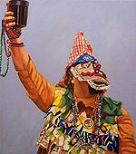 Courir de Mardi Gras.Artist Herb Roe
Since 1981, the Acadia St. Landry Medical Foundation, which supports the Acadia St. Landry Hospital, has organized an annual Buggy Festival, held in Church Point on the first weekend in June. The town was chosen because residents had used buggies as their main means of transportation until the early 1950s, earning Church Point the nickname "Buggy Capital of the world" in 1927.[2] In its first twenty-five years, the festival earned over $440,000 in profits, which were distributed among the hospital, the parks department of the city of Church Point, and various civic organizations. Two scholarships are also awarded annually.[6] The festival, which includes a Sunday parade, gives visitors the opportunity to explore various horse-drawn vehicles. Cajun musicians perform throughout the weekend, while Cajun cuisine is featured. The festival also often includes a French speaking contest and a Cajun French accordion contest.[5] Each year the town holds a Courir de Mardi Gras.
In 1987 Church Point established a relationship with Church Point, Nova Scotia, bringing about a revival of interest in its French culture.[2] The town now proudly calls itself the "Cajun Music Capital of the World," based on "having the greatest number of professional Cajun musicians of any place on earth."[5] A different Cajun musician is honored each year on Cajun Day, the second Sunday in November.[5]
Government
Church Point is organized under the Louisiana Lawrason Act and is governed by an elected mayor and five members of the Board of Alderman. These officials are responsible for implementing and carrying out laws for the advancement of interest, welfare, health, comfort, safety, and convenience of the community and its citizens. Elections are held every four years, with candidates taking office on the first day of July following the election and remaining in power for the next four years.[7]
References
- ^ http://www.codofil.org/english/lafrenchlanguage.html
- ^ a b c "History of Church Point". Acadia Parish Tourist Commission. 2007. Archived from the original on 2007-02-02. http://web.archive.org/web/20070202001439/http://www.acadiatourism.org/cphistory.htm. Retrieved 2007-03-19.
- ^ "US Gazetteer files: 2010, 2000, and 1990". United States Census Bureau. 2011-02-12. http://www.census.gov/geo/www/gazetteer/gazette.html. Retrieved 2011-04-23.
- ^ "American FactFinder". United States Census Bureau. http://factfinder.census.gov. Retrieved 2008-01-31.
- ^ a b c d "Church Point". Louisiana State University - Eunice. http://www.lsue.edu/acadgate/cp.htm. Retrieved 2007-03-19.
- ^ "Church Point Buggy Festival". The Church Point Buggy Festival. 2007. http://www.churchpointbuggyfestival.com/. Retrieved 2007-03-19.
- ^ Guillot, Jerry (February 2004). "The Lawrason Act" (PDF). Church Point, Louisiana. http://churchpoint-la.com/LAWRASON20ACT.pdf. Retrieved 2007-03-19.[dead link]
External links
Municipalities and communities of Acadia Parish, Louisiana Cities 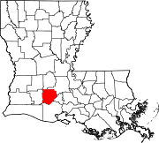
Towns Villages Estherwood | Mermentau | Morse
Unincorporated
communitiesArceneaux | Bates | Branch | Castille | Deshotel | Ebenezer | Egan | Ellis | Evangeline | Frey | Hundley | Judd | Keystone | Lyons Point | Maxie | Midland | Millerville | Mire | Mowata | Nezpique | Peach Bloom | Pitreville | Prudhomme | Richard | Roberts Cove | Rork | Tepetate | Tortue | Whitehouse | Williams
Footnotes ‡This populated place also has portions in an adjacent parish or parishes
Categories:- Populated places in Acadia Parish, Louisiana
- Towns in Louisiana
- Populated places established in 1843


Wikimedia Foundation. 2010.