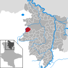
Meßdorf

Meßdorf
Meßdorf
Stadtteil of Bismark
Coat of arms of Meßdorf
Meßdorf is located in Germany
{{{alt}}}
Meßdorf
Coordinates 52°43′0″N 11°33′47″E / 52.716667°N 11.56306°E / 52.716667; 11.56306Coordinates: 52°43′0″N 11°33′47″E / 52.716667°N 11.56306°E / 52.716667; 11.56306
Administration
Country Germany
State Saxony-Anhalt
District Stendal
Town Bismark
Basic statistics
Area 27.89 km2 (10.77 sq mi)
Elevation 48 m  (157 ft)
Population 720  (31 December 2006)
 - Density 26 /km2 (67 /sq mi)
Other information
Time zone CET/CEST (UTC+1/+2)
Licence plate SDL
Postal code 39624
Area code 039083
Website www.altmark.de/vgbk

Meßdorf is a village and a former municipality in the district of Stendal, in Saxony-Anhalt, Germany. Since 1 January 2010, it is part of the town Bismark.


Wikimedia Foundation. 2010.

Игры ⚽ Поможем сделать НИР

Look at other dictionaries:

  • Meßdorf — Stadt Bismark (Altmark) Koordinaten …   Deutsch Wikipedia

  • Lessenich/Meßdorf — Stadt Bonn Koordinaten …   Deutsch Wikipedia

  • Bonn-Duisdorf — Duisdorf Stadt Bonn Koordinaten …   Deutsch Wikipedia

  • Büste (Altmark) — Büste Stadt Bismark (Altmark) Koordinaten …   Deutsch Wikipedia

  • Messdorfer Feld — Blick über das Feld Richtung Meßdorf Das Meßdorfer Feld ist die größte zusammenhängende Freifläche auf Bonner Gebiet und liegt im Westen der Stadt. Inhaltsverzeichnis 1 Geographie 2 Geschichte …   Deutsch Wikipedia

  • Bismark (Altmark) — Wappen Deutschlandkarte …   Deutsch Wikipedia

  • Dransdorf — Stadt Bonn Koordinaten …   Deutsch Wikipedia

  • A555 — Basisdaten Gesamtlänge: 18 km Bundesland: Nordrhein Westfalen Ausbauzustand …   Deutsch Wikipedia

  • A 555 — Basisdaten Gesamtlänge: 18 km Bundesland: Nordrhein Westfalen Ausbauzustand …   Deutsch Wikipedia

  • BAB 555 — Basisdaten Gesamtlänge: 18 km Bundesland: Nordrhein Westfalen Ausbauzustand …   Deutsch Wikipedia

Share the article and excerpts

Direct link
Do a right-click on the link above
and select “Copy Link”