- Bridgeport Covered Bridge
Infobox Bridge
bridge_name = View of the Bridgeport Covered Bridge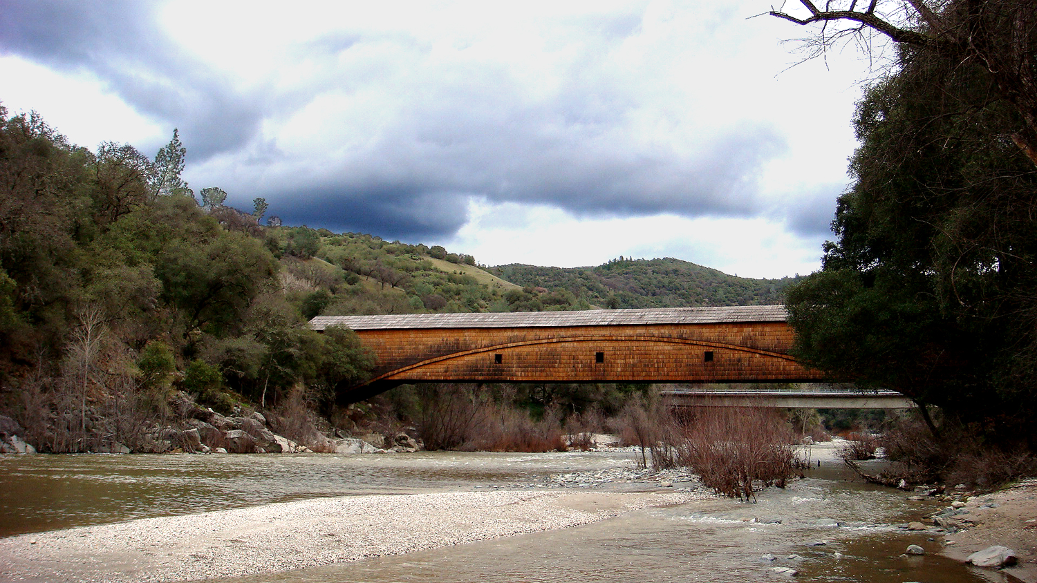
caption =
official_name =
carries = Pedestrian
crosses = South Yuba River
locale =
maint =
id =
design = Covered Bridge
mainspan =
length = convert|251|ft
width =
height =
load = 13 Tons (Current estimate at 3 tons due to age of timbers)
clearance =
below =
traffic =
begin =
complete =
open =
closed =
toll =
map_cue =
map_
map_text =
map_width =
coordinates =Infobox_nrhp3
name =Bridgeport Covered Bridge
nrhp_type =
caption =
nearest_city=French Corral , CA
area =
built =1862 cite web|url=http://memory.loc.gov/cgi-bin/ampage?collId=hhdatapage&fileName=ca/ca1300/ca1341/data/hhdatapage.db&title2=Bridgeport%20Covered%20Bridge,%20Spanning%20South%20Fork%20of%20Yuba%20River%20at%20bypassed%20section%20of%20Pleasant%20Valley%20Road%20(originally%20Virginia%20Turnpike)%20in%20South%20Yuba%20River%20State%20Park%20,%20Bridgeport,%20Nevada%20County,%20CA&recNum=0&itemLink=D?hh:1:./temp/~ammem_wSZh::|title=Library of Congress|date=1985-01-01|work=Historic American Engineering Record|publisher=]
architect= Unknown
locmapin=California
lat_degrees = 39 | lat_minutes = 17 | lat_seconds = 33.86 | lat_direction = N
long_degrees = 121 | long_minutes = 11 | long_seconds = 41.66 | long_direction = W
architecture= Howe Truss with an auxiliaryBurr Arch Truss cite web|url=http://memory.loc.gov/cgi-bin/ampage?collId=hhdatapage&fileName=ca/ca1300/ca1341/data/hhdatapage.db&title2=Bridgeport%20Covered%20Bridge,%20Spanning%20South%20Fork%20of%20Yuba%20River%20at%20bypassed%20section%20of%20Pleasant%20Valley%20Road%20(originally%20Virginia%20Turnpike)%20in%20South%20Yuba%20River%20State%20Park%20,%20Bridgeport,%20Nevada%20County,%20CA&recNum=0&itemLink=D?hh:1:./temp/~ammem_wSZh::|title=Library of Congress|date=1985-01-01|work=Historic American Engineering Record|publisher=]
added =July 14 ,1971 cite web|url=http://www.nr.nps.gov/|title=National Register Information System|date=2007-01-23|work=National Register of Historic Places|publisher=Library of Congress]
governing_body = Local
designated_other1_name = California Historic Landmark
designated_other1_date =
designated_other1_abbr = CHL
designated_other1_link = List of California Historical Landmarks
designated_other1_number = 390
designated_other1_color = #ffc94b
governing_body =
refnum=71000168 The Bridgeport Covered Bridge is reputed to be the longest single-span woodencovered bridge in the world. (Several sources claim that theOld Blenheim Bridge is the longest such bridge.)Historic Landmark
It was listed in the
National Register of Historic Places in 1971.It is also a California Registered Historical Landmark No. 390. The marker was placed in 1964 and the inscription reads:
Built in 1862 by David Isaac John Wood with lumber from his mill in Sierra County, this bridge was part of the Virginia Turnpike Company toll road which served the northern mines and the busy Nevada Comstock Lode. Utilizing a combination truss and arch construction, it is one of the oldest housed spans in the west and the longest single-span wood-covered bridge in the United States. [cite web |url=http://www.hmdb.org/marker.asp?marker=8540 |title=Bridgeport (Nyes Crossing) Covered Bridge |accessdate=2008-08-03 |last= |first= |coauthors= |date= |work= |publisher=HISTORICAL MARKER DATABASE]
The [http://www.ncgold.com/Museums_Parks/syrp/Bridgeport/ Nevada County, California website that claims Bridgeport Covered Bridge is the longest single span wooden covered bridge] also claims it is a the National Historic Landmark. However, the [http://tps.cr.nps.gov/nhl/ National Historic Landmark search system] does not report on the existence of this bridge as a National Historic Landmark.
References
External links
* [http://www.ncgold.com/Museums_Parks/syrp/Bridgeport/ Bridgeport Covered Bridge, at Nevada County, California website]
* [http://www.dot.ca.gov/hq/TransEnhAct/comp_proj/bridgept.htm Pictures of the Bridgeport Covered Bridge, at California Dept. of Transportation]
* [http://www.parks.ca.gov/?page_id=496 South Yuba River State Park]
* [http://memory.loc.gov/cgi-bin/query/D?hh:1:./temp/~ammem_wSZh:: Bridgeport Covered Bridge at the Library of Congress]
* [http://lostbridges.org/details.aspx?id=CA/05-29-01&loc=n Bridgeport Covered Bridge at the Covered Spans of Yesteryear website]
* [http://www.syrpa.lindberglce.com South Yuba River Park Adventures, pictures, events, maps, wildflowers]
Wikimedia Foundation. 2010.