- Guadalupe River (Texas)
Infobox River | river_name = Guadalupe River
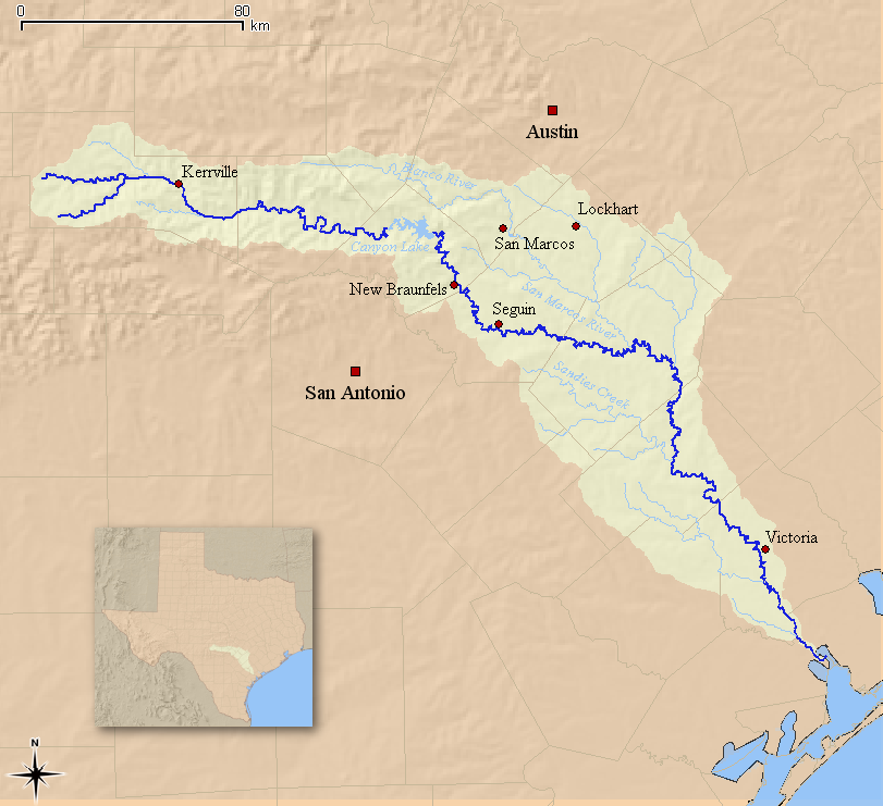
caption = Map of the Guadalupe River and associated watershed
origin = Kerr County,Texas , U.S.A
mouth =San Antonio Bay
basin_countries = U.S.A
length = 230 mi (370 km)
elevation = 2200 ft (671 m)
discharge = 1200 ft³/s (34 m³/s)
watershed = 2023 mi² (5240 km²)The Guadalupe River runs from Kerr County,
Texas , to theSan Antonio River near theGulf of Mexico . The river is a popular destination for rafters and canoers. Larger cities along the river include New Braunfels, Kerrville, Seguin, Gonzales, Cuero, and Victoria. The Guadalupe has several dams along its length, the most notable of which forms Canyon Lake northwest of New Braunfels.Course
The upper river, in the
Texas Hill Country , is a smaller, faster stream withlimestone banks and shaded bypecan andbald cypress trees. The upper Guadalupe is popular as a tubing destination where recreational users often float down the river on inflated tireinner tube s during the spring and summer months. East of Boerne, on the border ofKendall County andComal County , the river flows throughGuadalupe River State Park , one of the more popular tubing areas along the river.The lower river begins at the outlet of Canyon Lake, near New Braunfels. The section between
Canyon Dam and New Braunfels is the most heavily used in terms of recreation. It is a popular destination for whitewater rafters,canoe ists and kayakers. The flow varies according to the seasons, and by the amount of rainfall the area has received. It is joined by theComal River in New Braunfels and theSan Marcos River about two miles west of Gonzales. The Guadalupe below the San Marcos River is part of the course for theTexas Water Safari .Shortly before reaching the
Gulf of Mexico , the Guadalupe flows into the San Antonio River nearSan Antonio Bay .History
The river was first called after Nuestra Señora de Guadalupe by
Alonso de León in 1689. It was renamed the San Augustin by Domingo Terán de los Ríos who maintained a colony on the river, but the name Guadalupe persisted. Many explorers referred to the current Guadalupe as the San Ybón above its confluence with the Comal, and instead the Comal was called the Guadalupe. Evidence indicates that the river has been home to humans for several thousand years, including theKarankawa ,Tonkawa , andHuaco (pronounced like Waco) Indians.A sudden
flash flood on the river onJuly 17 ,1987 near Comfort swept a bus away from a nearby road. Forty-three were on the bus at the time as it left a church camp. Ten of them drowned, the rest were rescued mostly on treetops. [ [http://www.woai.com/news/local/story.aspx?content_id=cb218fe5-383d-4434-b072-bdd385c45f2f 10 Lives Lost: The 20th Anniversary of the Guadalupe River Disaster | WOAI.COM: San Antonio News ] ] On January 23, 1990, the story of the deaths and rescues and this flood was aired onRescue 911 ( [http://youtube.com/watch?v=gsC79X6lg-M see video] ) and it was later made into a television movie called "Flood: Who Will Save Our Children?".Fishing
The Guadalupe River is listed as one of the 100 top trout streams in the United States.Fact|date=August 2008 In addition to fly fishing for rainbow and brown trout on the tail-waters of the Guadalupe River below Canyon Lake, anglers can catch largemouth bass, smallmouth bass, Guadalupe bass, white bass, and the Rio Grande perch.
River Conditions / Flow
Guadalupe River conditions can change rapidly. The Guadalupe River flow is set by the dam at
Canyon Lake operated by theArmy Corps of Engineers . It is highly regulated and well maintained to ensure safety and fun. During the rainy seasons the water can reach well above the banks of the river and exceed “normal” levels, in which case the Guadalupe river will be closed to swimming.Fact|date=May 2008 If the flow gauge exceeds 1,000cubic feet per second at the Sattler Gage, then the Guadalupe River is closed to tubing.Fact|date=May 2008Points of interest
*
Riverside Nature Center ,Kerrville, Texas References
External links
*
* [http://www.edwardsaquifer.net/faults.html Edwards Aquifer]
* [http://www.tpwd.state.tx.us/spdest/findadest/parks/palmetto/ TPWD Palmetto State Park]
* [http://www.tpwd.state.tx.us/spdest/findadest/parks/guadalupe_river/ TPWD Guadalupe State Park]
*
Wikimedia Foundation. 2010.