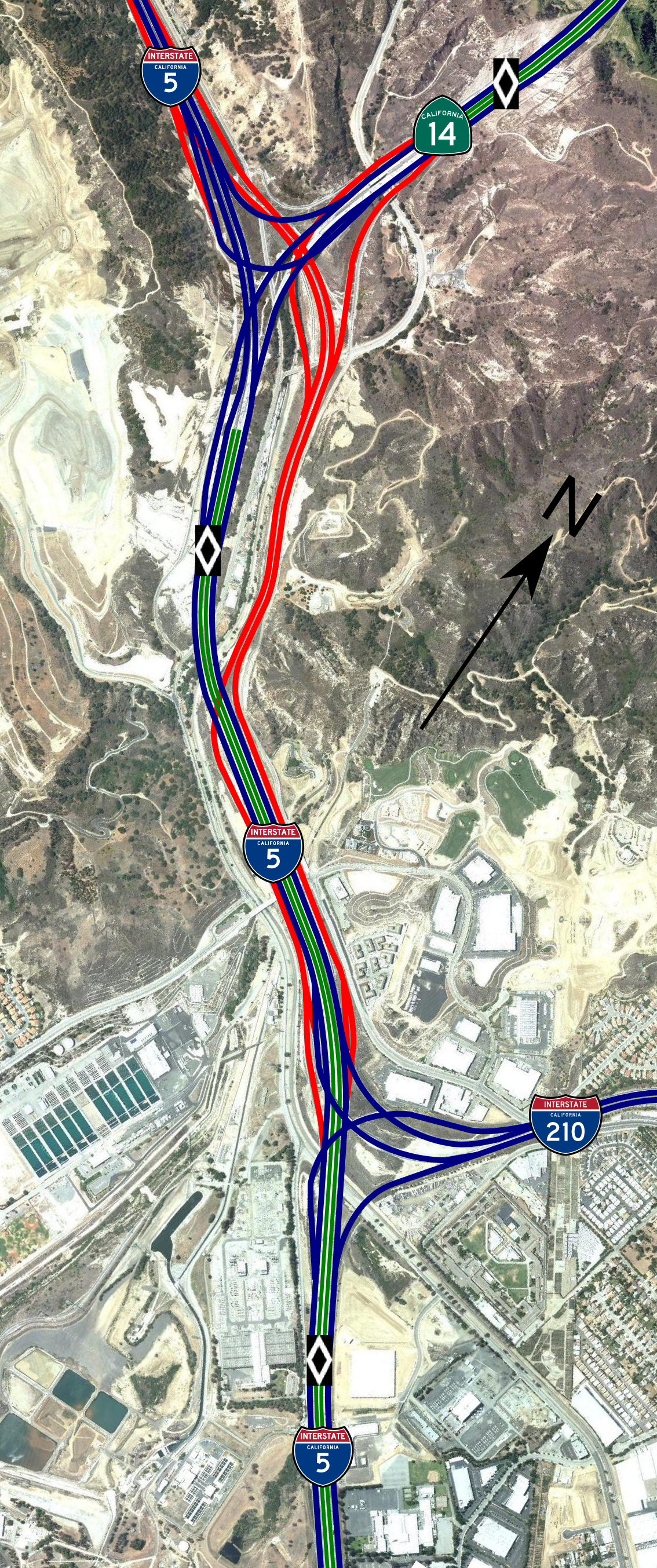
- Newhall Pass interchange
-
Newhall Pass Interchange Clarence Wayne Dean Memorial Interchange Location Santa Clarita Coordinates: 34°20′06″N 118°30′30″W / 34.335°N 118.50833°WCoordinates: 34°20′06″N 118°30′30″W / 34.335°N 118.50833°W Roads at
junction: I-5
I-5
 SR 14
SR 14Construction Maintained by: Caltrans Map 
The Newhall Pass Interchange (officially Clarence Wayne Dean Memorial Interchange) is a highway interchange at Newhall Pass, north of Sylmar in Southern California, United States. It connects Interstate 5 (Golden State Freeway) with State Route 14 (Antelope Valley Freeway), and includes truck bypass roadways (that can also be used by cars). The main I-5 truck bypass is the original four-lane freeway, built as U.S. Route 99.[1]
The 5-14 split, as the interchange is commonly referred to as by locals, is the northern most of five freeway interchanges on Interstate 5 within a 10 mile stretch. From south to north, the freeways that interchange with Interstate 5 include: California State Highway 170 in North Hollywood, California State Highway 118 in Panorama City, Interstate 405 in Sylmar, Interstate 210 also in Sylmar and ultimately the 14 freeway.
Contents
Incidents
1971 collapse
A total collapse of the southbound Interstate 5 to northbound State Route 14 overpass occurred as a result of the February 9, 1971 Sylmar earthquake. This collapse resulted in the additional collapse of the intersecting southbound State Route 14 to southbound I-5 overpass (as this connector bridge was directly beneath the 5/14 overpass). Both bridges fell directly onto the southbound I-5 truck bypass. The interchange was rebuilt in 1973, with additional steel rebar reinforcement.
1994 collapse
The January 17, 1994 Northridge earthquake caused the southbound State Route 14 to northbound I-5 connector to collapse. It also caused the south 14 to south I-5 overpass to collapse directly onto the main I-5 freeway and the southbound I-5 truck bypass, nearly exactly as had happened in the 1971 Sylmar earthquake. The latter collapse caused the death of Los Angeles Police Department motorcycle officer Clarence Wayne Dean, who fell from a broken-off edge when he was unable to stop in time.[2] The interchange was later dedicated the Clarence Wayne Dean Memorial Interchange in his honor. The collapse also closed the Metrolink's Antelope Valley Line, which began operation to Lancaster soon after.[3] The interchange was partially reopened on July 8,[4] and completed in 1995 with additional reinforcing on the overpass support columns.
2007 tunnel fire
Around 11 p.m. PDT on October 12, 2007, two trucks collided in the northernmost of two two-lane tunnels that take the southbound truck bypass roadway under the eight mainlanes of I-5 where it travels adjacent to the northbound truck bypass lanes. The tunnel is a 550 ft (167 m) long reinforced concrete box girder, built in 1975. It was last inspected in April 2007, and no problems were found.[citation needed]
Thirty commercial vehicles and one passenger vehicle were involved in the traffic collision. A resulting fire soon spread from vehicle to vehicle, eventually encompassing the entire tunnel with flames shooting nearly 100 feet (30 m) outside the tunnel and burning at around 1,400 °F (760 °C).[citation needed]. Three people died - including a 38-year-old male truck driver and his 6-year-old male passenger - and ten people were injured, none critically.[5]
As a result of the accident and ensuing fire, all lanes of I-5 between Calgrove Boulevard and State Route 14 were closed. In addition, the southbound onramps between State Route 126 and Calgrove Boulevard were closed[citation needed] along with the northbound approaches from State Route 14 and Interstate 210.[6]
Firefighters finished removing debris from the tunnel at 7 a.m. on October 14. Inspectors found heavy damage to the tunnel walls under the north portal. They also found a lot of spalling and exposed rebar, both of which can cause a loss of vertical support. However, the tunnel roof (or bridge) was found to be sound.[7] Caltrans worked through the weekend of October 13 and 14 to clear out and install five shoring supports inside the tunnel. At 4:20 p.m. on October 14, Caltrans opened up the two northbound truck bypass lanes to all traffic.
On Monday, October 15, the southbound mainline lanes of I-5 were reopened at 1:00 am. The northbound mainlane lanes were reopened two hours later. The speed limit on the southbound lanes was lowered to 55 mph (90 km/h) to help with the flow due to heavier congestion than normal.[citation needed] Emergency funding for the repairs was authorized for the damaged tunnel.[8] Contractor C. C. Myers was placed on site with materials and workers to perform any needed repairs. During the repairs the southbound I-5 truck lanes remained closed, while southbound trucks through the interchange were diverted onto the auto lanes.
The southbound I-5 truck lanes were reopened on Thursday, November 15, 2007. Security Paving of Oxnard performed the remaining repairs and made safety improvements to the tunnel which included the following:
- New pavement for the tunnel walls and the roadway.
- Improved tunnel lighting for both sides of the tunnel. This lighting is set to adjust depending on the weather conditions outside the tunnel.
In addition, the speed limit on the tunnel was lowered back to 45 mph (70 km/h).[9]
Projects
HOV Direct Connector Project
Caltrans is currently constructing an elevated HOV (high-occupancy vehicle) direct connector ramp to link the recently-completed I-5 HOV lanes to the existing CA-14 HOV lanes.[10] This direct connector will allow motorists a freeway-to-freeway transfer without exiting the carpool lane.
As of July 2008, Caltrans has begun preliminary construction work. The project will cost $156.6 million and is scheduled for completion in 2012.
I-5 HOV/Truck Lane Project
Caltrans is currently carrying out environmental review of the I-5 HOV/Truck Lanes Project.[11] This project will widen I-5 from the Newhall Pass Interchange north to Parker Road with new HOV lanes and truck lanes. The new HOV and truck lanes would connect with the existing HOV and truck lanes of the Newhall Pass Interchange. This project will cost approximately $2.8 billion.
References
- ^ Caltrans photos of the interchange, 1956 and 1963
- ^ http://www.nytimes.com/1994/01/25/us/earthquake-city-motorcycle-cop-mystique-officer-quake-victim-laid-rest.html?pagewanted=1
- ^ U.S. Department of Transportation, Effects of Catastrophic Events on Transportation System Management and Operations: Northridge Earthquake- January 17, 1994, April 22, 2002
- ^ Los Angeles Daily News, Metrolink Fares Set to Increase, July 13, 1994
- ^ LA Times
- ^ Caltrans road conditions
- ^ Caltrans District 7 News Release, October 14, 2007
- ^ Caltrans District 7 News Release, October 14, 2007
- ^ KNBC.com-Channel 4 News
- ^ [1]
- ^ [2]
External links
Categories:- Southern California freeways
- Road interchanges in California
- Interstate 5
- Road accidents in the United States
- Bridge disasters in the United States
- Bridge disasters caused by earthquakes
- 1971 in the United States
- Transport disasters in 1971
- 1994 in the United States
- 1994 road accidents
- 2007 in the United States
- 2007 road accidents
- Fires in California
- Santa Susana Mountains
- Burned building and structures in the United States
Wikimedia Foundation. 2010.