- Salem, Indiana
Infobox Settlement
official_name = City of Salem
native_name =
settlement_type =City
nickname =
motto =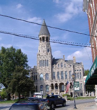
imagesize =
image_caption = Washington County Courthouse, in the town square
image_
image_
mapsize = 250x200px
map_caption = Location in the state ofIndiana
mapsize1 =
map_caption1 =
subdivision_type = Country
subdivision_name =United States
subdivision_type1 = State
subdivision_name1 =Indiana
subdivision_type2 = County
subdivision_name2 = Washington
subdivision_type3 = Township
subdivision_name3 = Washington
government_type =
leader_title =Mayor
leader_name = David L. Bower (D)
leader_title1 =
leader_name1 =
leader_title2 =
leader_name2 =
leader_title3 =
leader_name3 =
established_title =
established_date =
established_title2 = Town founded
established_date2 = 1814
established_title3 =
established_date3 =
area_magnitude = 1 E7
area_total_km2 = 10.1
area_total_sq_mi = 3.9
area_land_km2 = 10.1
area_land_sq_mi = 3.9
area_water_km2 = 0.1
area_water_sq_mi = 0.04
area_water_percent = 0.51
area_urban_km2 =
area_urban_sq_mi =
area_metro_km2 =
area_metro_sq_mi =
population_as_of = 2000
population_note =
population_total = 6172
population_density_km2 = 612.6
population_density_sq_mi = 1586.8
population_metro =
population_density_metro_km2 =
population_density_metro_sq_mi =
population_urban =
timezone = EST
utc_offset = -5
timezone_DST = EDT
utc_offset_DST = -4
latd = 38 |latm = 36 |lats = 15 |latNS = N
longd = 86 |longm = 5 |longs = 56 |longEW = W
elevation_m = 229
elevation_ft = 751
postal_code_type = ZIP Code
postal_code = 47167
website = http://www.cityofsalemin.com/
area_code = 812
blank_name = FIPS code
blank_info = 18-67464GR|2
blank1_name = GNIS feature ID
blank1_info = 0442876GR|3
footnotes = Salem is a city in Washington Township, Washington County,Indiana ,United States . Salem serves as thecounty seat GR|6, and its downtown area is on theNational Register of Historic Places (as are several local buildings).Geography
Salem is primarily an agricultural community, surrounded by typical Indiana forests and farmland and small bodies of water. The primary crop grown in the area is corn. Homes in the area are of a variety of styles, with a large portion of residential homes having Victorian architectural design.
Demographics
As of the
census GR|2 of 2000, there are 2,555 households, and 1,635 families residing in the city. There are 2,745 housing units at an average density of 705.7/sq mi (272.5/km²). The racial makeup of the city is 98.74% White, 0.03% African American, 0.21% Native American, 0.24% Asian, 0.08% from other races, and 0.70% from two or more races. Hispanic or Latino of any race are 0.42% of the population.29.2% of households have children under the age of 18 living with them, 47.4% are married couples living together, 12.3% have a female householder with no husband present, and 36.0% are non-families. 32.1% of all households were made up of individuals and 15.7% had someone living alone who was 65 years of age or older. The average household size was 2.29 and the average family size was 2.84.
The population consists of 22.4% under the age of 18, 9.8% from ages 18 to 24, 27.1% from ages 25 to 44, 21.2% from ages 45 to 64, and 19.4% from ages 65 or older. The median age is 38 years. For every 100 females there are 86.2 males. For every 100 females age 18 and over, there are 83.0 males.
The median income for a household in the city is $29,256, and the median income for a family is $37,179. Males have a median income of $27,521 versus $21,952 for females. The
per capita income for the city is $16,299. About 8.5% of families and 11.6% of the population live below thepoverty line , including 14.6% of those under age 18 and 5.7% of those age 65 or over.Government
Mayor - David BowerClerk-Treasurer - Patricia Persinger
City Council 1st District - Mark W. HobsonCity Council 2st District - Pete D. BrownCity Council 3rd District - Ginger B. MorrisCity Council 4th District - Wally TerkhornCity Council At-Large - Nancy E. FultzHistory
Morgan's Raid
In June 1863, the Confederate
cavalry underJohn Hunt Morgan had departedTennessee on what would later became known asMorgan's Raid . Traveling through Tennessee and into Kentucky, Morgan eventually crossed into Indiana; he reached Salem onJuly 10 ,1863 , coming north from Corydon. Upon entering Salem at approximately 9 a.m., Morgan immediately took possession of the town and placed guards over the stores and streets. The cavalrymen burned the large, brick railroad depot, along with all the train cars on the track and the railroad bridges on each side of the town. Morgan demanded taxes from the twoflour mill s that belonged to DePauw and Knight, and from the Allen Wollen Mill. Morgan's men looted stores and took about $500 from the area before departing about 3 p.m.Of the brief action at Salem, Col.
Basil W. Duke , Morgan's second-in-command and brother-in-law, later said:"They did not pillage with any sort of method or reason; it seemed to be a mania, senseless and purposeless. One man carried for two days a bird cage containing three canaries. Another rode with a huge chafing dish on the pommel of his saddle. Although the weather was intensely warm, another slung seven pairs of
skates around his neck. I saw very few articles of real value taken; they pillaged like boys robbing anorchard ."Famous residents
John Hay , private secretary to PresidentAbraham Lincoln and Secretary of State to PresidentsWilliam McKinley andTheodore Roosevelt , was born in Salem and is generally known as Salem's most prominent citizen. A variety of museums and local buildings make reference to Mr. Hay's connections to the town.Roy Robertson invented the process for making 2%
milk while working at the Salem Creamery, where it was first produced and marketed. He was unable to obtain a patent and the invention was credited to someone else.Local Attractions
Located in the center of Salem's town square, the Washington County Courthouse is generally known as Salem's most famous and recognizable landmark. The courthouse has historical placemarkers surrounding it, and at the southeastern corner of the grounds, there is a memorial to veterans killed in action during conflicts dating back to the
Revolutionary War .Unusual for a town of this size is a large children's playground, "Riley's Place" at DePauw Park. Named after Riley Jean Tomlinson, a local toddler who accidentally drowned in a swimming pool, the park was built in 2001 and contains two- and three- story wooden castles and other structures for children's play (along with swings, slides, and similar playground equipment).
Every September, Salem celebrates "Old Settler's Day" at the
John Hay Center . Set in a village of authentic log structures, the festival features historical re-enactments, as well as local arts and crafts.References
* Indiana Historical Commission. "Archaeological and Historical Survey of Washington County" (August 1924). Wm. B. Burford
External links
* [http://cityofsalemin.com/ Official Web site]
* [http://www.salemindiana.com Salem High School alumni]
Wikimedia Foundation. 2010.