- São Sebastião (Ponta Delgada)
-
São Sebastião Civil Parish (Freguesia) 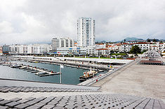 The urbanized coastal limit of Ponta Delgada at São Sebastião, including the commercial mall and business quarter, as seen from the Portas do Mar
Official name: Freguesia de São Sebastião Name origin: Portuguese for Saint Sebastian Country  Portugal
Autonomous Region  Azores
Group Central Island São Miguel Municipality Ponta Delgada Center Santana - elevation 65 m (213 ft) - coordinates 37°44′54″N 25°40′15″W / 37.74833°N 25.67083°W Highest point Milhafres - elevation 254.46 m (835 ft) - coordinates 37°46′9″N 25°40′26″W / 37.76917°N 25.67389°W Lowest point Sea Level - location Atlantic Ocean Length 3.78 km (2 mi), North-South Width 119 km (74 mi), West-East Area 3.34 km2 (1 sq mi) - land 2.25 km2 (1 sq mi) - water .00 km2 (0 sq mi) - urban 1.09 km2 (0 sq mi) Population 4,309 (2001) Density 1,290.12 / km2 (3,341 / sq mi) LAU Freguesia/Junta Freguesia - location Rua Dr. Bruno Tavares Carreiro, São Sebastião, Ponta Delgada President Junta Fátima Fernanda da Silva Pimentel Timezone Azores (UTC-1) - summer (DST) Azores (UTC0) ISO 3166-2 code PT- Postal Zone 9500-055 São Sebastião Area Code & Prefix (+351) 292 XXX-XXXX Demonym Micalense Patron Saint São Sebastião Parish Address Rua Dr. Bruno Tavares Carreiro, 31-35
9500-055 São SebastiãoWikimedia Commons: São Sebastião (Ponta Delgada) Statistics from INE (2001); geographic detail from Instituto Geográfico Português (2010) São Sebastião (Portuguese for Saint Sebastian) is a parish in the district of Ponta Delgada in the Azores. The population in 2001 is 4309, its density is 1290.12/km² and the area is 3.34 km². The parish is part of the downtown area of Ponta Delgada and is the second in density as well as third in population in Ponta Delgada. Until June 30, 2003, the parish was known as Matriz (Ponta Delgada).
Contents
Geography
São Sebastião also has a school, a lyceum, a gymnasium, a church and a few squares (praças), including the main garden (Jardim de Francisco Bettencourt).
Architecture
Civic
- City Gates (Portuguese: Portas da Cidade)
- Caixa Geral de Depósitos (CGD) Building
- Comando da Defesa Marítima of Ponta Delgada Building
- Correios, Telégrafos e Telefones (CTT) Building
- Estate of Solar do Condes de Albuquerque
- Estate of Solar José do Canto (also known as Solar Scholtze or Solar Bérquos)
- Estate of Solar São Joaquim
- House on Rua do Melo No.62 (Portuguese: Casa Carlos Bicudo)
- House on Rua Dr. Guilherme Poças, No.14
- House on Rua Dr. Luís Bettencourt, No.24-28
- House on Rua Margarida Chaves, No.28
- House in Largo Marquês de Pombal
- Hospital of Ponta Delgada
- Palace of Santana, also known as the Palace of Jácome Correia - the official residence of the President of the Regional Government of the Azores
Religious
- Chapel of Sant' Ana
- Church of the Jesuit College, located in the Largo do Marques de Pombal, half a kilometre north of the historic centre, the Church was part of a group of buildings constructed by the Campanhia do Jesus (the Jesuits) to provide ecclesiastical education to the residents of Ponta Delgada. The church, officially the Church of Todos-os-Santos (All Saints) was constructed through the initiatives of João Lopes, who convinced the Jesuit priests and Diocese of Angra to establish their school. The church is characterized by a grande façade of imposing doors, circular windows and verandas, topped by an incomplete double clock-tower. It is one of the peripheral buildings of the Carlos Machado Museum (sacred arts wing), the home of the Library and Archive of Ponta Delgada, and its convent annexes occupied by offices of the regional government.
- Church of São Sebastião
- Church of Santa Bárbara
- Convent of Santo André* Chapel of São Bráz
Categories:- Parishes of Ponta Delgada (Azores)
- Azores geography stubs

Wikimedia Foundation. 2010.