- Meaher State Park
-
Meaher State Park 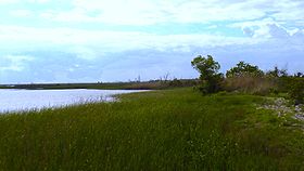
Type State Park Location 5200 Battleship Parkway East
Spanish Fort, Alabama, U.S.A.Coordinates 30°40′11″N 87°56′10″W / 30.66973°N 87.93604°W Area 1,327 acres (5.37 km2) Operated by Alabama Department of Conservation and Natural Resources Meaher State Park is a state park located in Spanish Fort, Alabama. The park is accessed from the Battleship Parkway, also known locally as the Mobile Bay Causeway. The 1,327-acre (5.37 km2) facility is located on an island located at the north end of the bay and surrounded by wetlands of the Mobile Bay estuary.[1]
Amenities
The park is available for day use or camping. The camping area has 56 individual campsites. The park also features picnic areas, two nature trails with a boardwalk through the wetlands, a boat ramp and a fishing pier.[1]
References
- ^ a b "Meaher State Park". "Alabama State Parks". http://www.alapark.com/parks/park.cfm?parkid=24. Retrieved 2007-09-08.
External links
Protected Areas of Alabama Federal Bon Secour • Cahaba River • Choctaw • Eufaula • Fern Cave • Key Cave • Mountain Longleaf • Santa Cave • Watercress Darter • Wheeler
Wilderness AreasState Bladon Springs • Blue Springs • Buck's Pocket • Cathedral Caverns • Chattahoochee • Cheaha • Chewacla • Chickasaw • DeSoto • Florala • Frank Jackson • Gulf • Joe Wheeler • Lake Guntersville • Lake Lurleen • Lakepoint • Meaher • Monte Sano • Oak Mountain • Paul M. Grist • Rickwood Caverns • Roland Cooper • Wind Creek
Fayette • Geneva • Little River • Saint Stephens • Weogufka
Alabama Department of Conservation and Natural Resources (web) Categories:- Alabama state parks
- Protected areas of Baldwin County, Alabama
- Mobile Bay

Wikimedia Foundation. 2010.