- Cascade City, British Columbia
Infobox Settlement
official_name = Cascade City, British Columbia
other_name = aka: Cascade, British Columbia
native_name =
nickname = Gateway to the Boundary Country
settlement_type =Ghost town
motto =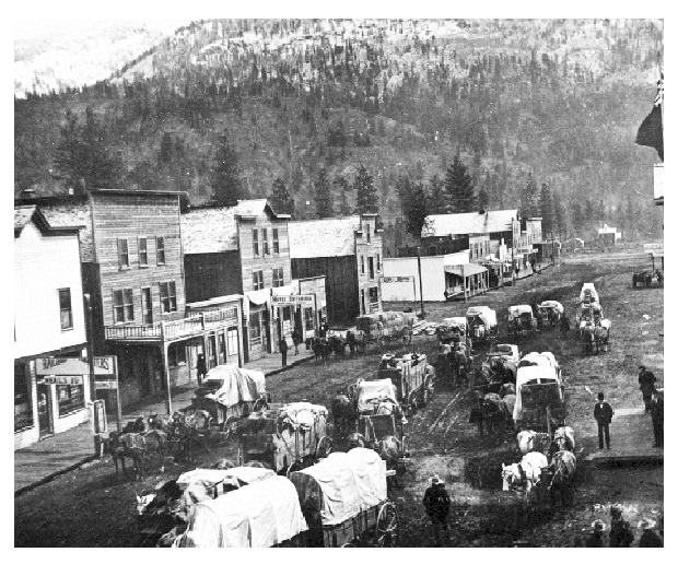
imagesize =
image_caption =American freight wagons at Cascade City in 1898
flag_size =
image_
seal_size =
image_shield =
shield_size =
city_logo =
citylogo_size =
mapsize =
map_caption =
mapsize1 =
map_caption1 =
image_dot_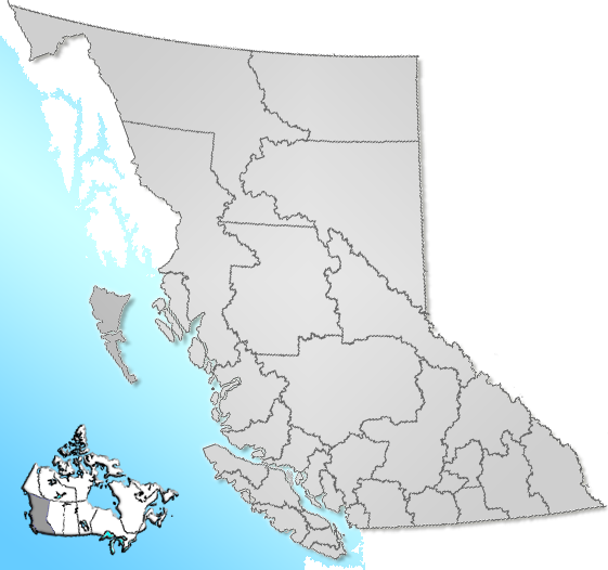
dot_mapsize =220px
dot_map_caption =Location of Cascade City inBritish Columbia
dot_x =165 |dot_y =180
subdivision_type = Country
subdivision_name = CAN
subdivision_type1 = Province
subdivision_name1 = BC
subdivision_type2 = Regional District
subdivision_name2 = Kootenay Boundary
subdivision_type3 =
subdivision_name3 =
subdivision_type4 =
subdivision_name4 =
government_footnotes =
government_type =
leader_title =
leader_name =
leader_title1 = Governing body
leader_name1 =
leader_title2 =
leader_name2 =
leader_title3 =
leader_name3 =
leader_title4 =
leader_name4 =
established_title = Founded
established_date =1896
established_title2 =
established_date2 = (town)
established_title3 =
established_date3 = (city)
area_magnitude =
unit_pref =
area_footnotes =
area_total_km2 =
area_land_km2 =
area_water_km2 =
area_total_sq_mi =
area_land_sq_mi =
area_water_sq_mi =
area_water_percent =
area_urban_km2 =
area_urban_sq_mi =
area_metro_km2 =
area_metro_sq_mi =
population_as_of =
population_footnotes =
population_note =
population_total = 0
population_density_km2 =
population_density_sq_mi =
population_metro =
population_density_metro_km2 =
population_density_metro_sq_mi =
population_urban =
population_density_urban_km2 =
population_density_urban_sq_mi =
population_blank1_title =1890's
population_blank1 =1,500
population_density_blank1_km2 =
population_density_blank1_sq_mi =
timezone = PST
utc_offset = -8
timezone_DST =
utc_offset_DST =
latd= 49|latm=01 |lats= |latNS=N
longd=118 |longm=12 |longs= |longEW=W
elevation_footnotes = [cite web|author=Falling Rain|title=Cascade|url=http://www.fallingrain.com/world/CA/2/Cascade.html|accessdate=2007-07-24]
elevation_m =
elevation_ft = 1660
postal_code_type = Postal code span
postal_code =
area_code =
blank_name =
blank_info =
blank1_name =
blank1_info =
website =
footnotes =
Cascade City or Cascade was aCanadian Pacific Railway construction era boom town in theBoundary Country of the West Kootenay region ofBritish Columbia ,Canada . Because of its location near theCanada–United States border , it was also called the "Gateway to the Boundary Country".rp|163Founded in
1896 , it was named after the nearby Cascade Falls [cite web|author=Waterfalls West|title=Cascade Falls
url=http://www.waterfallswest.com/bc-cascade-falls.html|accessdate=2007-07-24] on the Kettle River.cite book |last=Ramsey |first=Bruce |title=Ghost Towns of British Columbia|year=1963|publisher=Mitchell Press|isbn=Unknown|pages="various"]Cascade City was located 1 km north of the Canada–United States border, 6 km south of Christina Lake and 20 km east of Grand Forks.
History
The property at Cascade City was originally owned by an American, Aaron Chandler, from
North Dakota . Seeing the potential of the area, Chandler formed the Cascade Development Company and with his agent, George Stocker,cite book|last=Turnbull|first=Elsie|title=Ghost Towns and Drowned Towns of West Kootenay|year1988=|publisher=Heritage House|isbn=0-919214-61-4] subdivided the land into town lots and began selling them to enterprising businessmen.cite web|author=Kootenay Rockies|title= Ghost Towns|url=http://www.kootenayrockies.com/partners/partner.html?id=339&catid=6|accessdate=2007-07-24] Powerhouse on Kettle River in 1910
hydro electric dam andpowerhouse was built on Kettle River in 1897.cite book |last=Paterson |first=Thomas |title=Encyclopedia of Ghost Towns and Mining Camps of British Columbia|year=1963|publisher=Sunfire Publications|isbn=0-88983-02-4|pages="various"] rp|160 The powerhouse would provide electricity to Grand Forks, Phoenix and Greenwood. [cite web|author=Travel British Columbia|title=Christina Lake History|url=http://www.travel-british-columbia.com/kootenay_rockies/christina_lake.aspx|accessdate=2007-07-24]The early townsite only had two buildings: a
general store and a restaurant. Chandler himself slept in atent . However, by the time the railway construction crews arrived in 1898, Cascade City was booming and although there were fourteen hotels, there was rarely a room available.rp|166 There were numerousbrothels where an estimated 60rp|166 ladies of the evening, such as "Scrap Iron Minnie" and "Rough Lock Nell" plied their trade.rp|166The first local government began with the creation of the Tax Payer's Association in December, 1897. The members petitioned the provincial government at Victoria for schools, roads, bridges, a provincial police constable and a jail.rp|160
The Doon gang and the tobacco robbery
The need for police and a jail had become evident just the previous month before the Association was formed when a gang broke into the British Columbia Mercantile and Mining Syndicate's store, relieving them of 150 pounds of
tobacco and oneshotgun .rp|160The store's manager, Stanley Mayall, realized that the thieves intended to sell the tobacco and informed every nearby store and mining camp of the crime. It wasn't long before the owner of a tobacco shop approached Mayall with the news that he had a rough-looking salesman in his store trying to sell him a large quantity of tobacco. Because there were no local police, Mayall's
book-keeper was swiftly armed and deputized and sent to make the arrest.rp|160The book-keeper, a man by the name of Morgan, successfully made the arrest and detained the suspect, John Doon, in a sturdy house that belonged to a local carpenter. Later that evening, Morgan found his new found duties were called for again, when the storekeeper came back to tell Mayall that a second man was in his store inquiring after the first. The second arrest was also successful, but not as peaceful, as Morgan had to wrestle a 12 inch long
Bowie knife away from the man. Back at the carpenter's house, this second man turned to Doon and asked, "Where are the other three?", alerting Mayall and Morgan to that fact that they had three more arrests to make before the case was closed.rp|162The two in custody were sent to Grand Forks to stand trial and then a third man was arrested in Cascade. While he was incarcerated at the carpenter's house, the final two men tried to free him. The town watchman, an
Irishman by the name of Pat Kennedy tried to arrest them but was shot in the chest. Nevertheless, he doggedly pursued the three robbers and captured one, while the other two escaped across the border. The last member was taken to Grand Forks to join the other two in custody, and they were all given $50 fines and sentenced six months in jail.rp|163The coming of the railroad
When it was announced that the CPR intended to build a
smelter at Cascade, the town's future seemed assured. The local newspaper, the "Cascade Record" raved about the potential employment opportunities that the $500,000 smelter brought to the town and predicted that it would employ 500 to 2,000 men.rp|164 The town's hopes would soon be shattered, however, when the railway chose to build the smelter in Trail instead.On August 12th, 1899, the
Columbia and Western Railway , later CPR, arrived in Cascade City from the Kettle River Bridge.rp|161 The town held a celebration and $25 was donated for refreshments for the railway's labourers.The fires
On September 30th, 1899, just over six weeks after the arrival of the railway, Cascade City was hit by a devastating fire. The blaze started in an empty shack and spread rapidly, burning down six hotels and several other structures within the space of half an hour. The town had no fire department and the decision was made to create a
firebreak by usingdynamite on some of the threatened buildings. One man's life was lost when he rushed into a hotel to rescue some patrons. Few of the hotels that were lost had fire insurance.rp|165Rebuilding had scarcely begun when the town was hit by another major fire in 1901.rp|169 All but 75 of the residents left and the town faded into obscurity. [cite web
author=Greenwood Museum|title=Surrounding Towns and Ghost Towns of Boundary Country|url=http://www.greenwoodheritage.bc.ca/History-Info/surrounding_towns_ghost_towns.html|accessdate=2007-07-24]Today
For many years, Cascade survived as a
customs port. In 1920 there were 150 residents and a store. The powerhouse closed in that late 20's and the final blow came in 1947, when the historic Ritchie store and the post-office burned down.rp|166The CPR station was abandoned by 1968 and the post office was amalgamated with the Christina Lake Post Office in 1973. [BCGNIS|29225|Cascade]Today, the only remainder of Cascade City is the old
cemetery on the opposite side of the Kettle River. The Christina Lake Golf Club's 18 holegolf course sits on much of what was the original townsite.rp|166ee also
*
List of ghost towns in British Columbia Further reading
*cite book |last=Paterson |first=Thomas |title=Encyclopedia of Ghost Towns and Mining Camps of British Columbia|year=1963|publisher=Sunfire Publications|isbn=0-88983-02-4
*cite book |last=Ramsey |first=Bruce |title=Ghost Towns of British Columbia|year=1963|publisher=Mitchell Press|isbn=Unknown|pages=
*cite book|last=Turnbull|first=Elsie|title=Ghost Towns and Drowned Towns of West Kootenay|year1988=|publisher=Heritage House|isbn=0-919214-61-4Notes
External links
*cite web|author=Kootenay Rockies|title= Ghost Towns|url=http://www.kootenayrockies.com/partners/partner.html?id=339&catid=6|accessdate=2007-07-24
*cite web
author=Crows Nest Highway
title=Cascade City
url=http://www.crowsnest-highway.ca/cgi-bin/citypage.pl?city=christina_lake
accessdate=2007-07-24
*cite web
author=Greenwood Museum
title=Surrounding Towns and Ghost Towns of Boundary Country
url=http://www.greenwoodheritage.bc.ca/History-Info/surrounding_towns_ghost_towns.html
accessdate=2007-07-24
*cite web
author=Travel British Columbia
title=Christina Lake History
url=http://www.travel-british-columbia.com/kootenay_rockies/christina_lake.aspx
accessdate=2007-07-24
*cite web
author=Waterfalls West
title=Cascade Falls
url=http://www.waterfallswest.com/bc-cascade-falls.html
accessdate=2007-07-24
*cite web
author=Falling Rain
title=Cascade
url=http://www.fallingrain.com/world/CA/2/Cascade.html
accessdate=2007-07-24
*BCGNIS|29225|Cascade
Wikimedia Foundation. 2010.