- Mount Waiʻaleʻale
Geobox|Mountain
name = Waiokinaaleokinaale
native_name =
other_name =
category =
etymology =
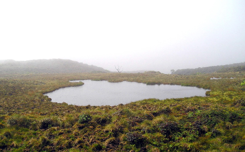
image_caption =Waialeale(Lake) or Rippling Waters, the small lake that is the namesake of Waialeale.
country = US
state = HI
region =Kauai
district =
municipality =
range =
location =
elevation_imperial = 5066
prominence_imperial =
lat_d = 22 | lat_m = 04 | lat_s = 26 | lat_NS = N
long_d = 159 | long_m = 29 | long_s = 55 | long_EW = W
length_imperial = | length_orientation =
width_imperial = | width_orientation =
height_imperial =
depth_imperial =
volume_imperial =
area_imperial =
area_land_imperial =
area_water_imperial =
area_urban_imperial =
area_metro_imperial =
discharge_imperial =
geology =
orogeny =
period =
biome =
plant =
animal =
public =
access =
ascent = | ascent_date =
free = | free_type =
map_caption =
map_background =
map_locator =
map_locator_x =
map_locator_y =
website =
footnotes =Mount Waiokinaaleokinaale (pronounced wai uh-lay uh-lay) (literally, "rippling water" or "overflowing water" in Hawaiian [Cite book | author=Pukui, Mary Kawena | authorlink= | coauthors= | title=Place Names of Hawaii | date= | publisher=University of Hawaii Press | location= | isbn=0-8248-0524-0 | pages=] and also often spelt Waialeale in English without the okinaokina), elevation 5,148 ft (1,569 m), is the second highest point on the island of Kauaokinai in the
Hawaiian Islands . Averaging more than 460 inches (11,680 mm) of rain over the last 32 years, with a record 683 inches (17,340 mm) in1982 , its summit is considered one of the rainiest spots on earth. It has been promoted in tourist literature for many years as "the" wettest spot, although the 38-year average atMawsynram ,India is 11,873 mm (467.4 inches). However, Mawsynram's rainfall is concentrated in themonsoon season, while the rain at Waialeale is more evenly distributed through the year.Several factors give the summit of Waiokinaaleokinaale more potential to create precipitation than the rest of the island chain:
# Its northern position relative to the main Hawaiian Islands provides more exposure to frontal systems that bring rain during the winter.
# It has a relatively round and regular conical shape, exposing all sides of its peak to winds and the moisture that they carry.
# Its peak lies just below the so-calledtrade wind inversion layer of 6,000 feet (1,800 m), above which trade-wind-produced clouds cannot rise.
# And most importantly, the steep cliffs cause the moisture-laden air to rise rapidly - over 3,000 ft (1,000 m) in less than half a mile - and drop a large portion of its rain in one spot, as opposed to spreading the rain out over a larger area if the slope were more gradual.The great rainfall in the area produces the
Alakai Wilderness Area , a large boggy area that is home to many rare plants. The ground is so wet that although trails exist, access by foot to the Waiokinaaleokinaale area is extremely difficult.External links
* [http://starbulletin.com/2002/05/27/news/story3.html Honolulu Star-Bulletin article on Waiokinaaleokinaale]
* [http://www.waialeale.org Site with hiking info on routes to Waialeale and Kawaikini and summit photos.]
* [http://waterdata.usgs.gov/hi/nwis/uv?site_no=220427159300201&PARAmeter_cd=00045 "Real-time" rainfall data from the USGS Waiokinaaleokinaale Raingauge]
Wikimedia Foundation. 2010.