- Washington State Route 129
Infobox road
state=WA
type=SR
route=129
maint=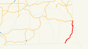
length_mi=42.55
length_round=2
length_ref=cite web |author=Washington State Department of Transportation |url=http://www.wsdot.wa.gov/mapsdata/tdo/PDF_and_ZIP_Files/HwyLog2006.pdf |title=State Highway Log, 2006 |accessdate=2008-09-24 |format=pdf]
established=1964cite web |url=http://apps.leg.wa.gov/RCW/default.aspx?cite=47.17.260 |title=RCW 47.17.260: State Route 129 |author=Washington State Legislature |accessdate=2008-09-25]
direction_a=South
terminus_a=jct|state=OR|OR|3 atOregon state line near Anatone
direction_b=North
terminus_b= jct|state=WA|US|12 in Clarkston
previous_type=SR
previous_route=128
next_type=SR
next_route=131State Route 129 (SR 129) is a state highway in the U.S. state of
Washington , located in Asotin County. It extends convert|42.55|mi|km|2 fromOregon Route 3 (OR 3) at theOregon state line south of Anatone, north to U.S. Route 12 (US 12) in Clarkston. The route serves as a connector betweenEnterprise, Oregon and Clarkston.SR 129 has its own
spur route located in Clarkston. SR 129 was part of Primary State Highway 3's Clarkston branch (PSH 3 DC) from 1937 until 1964, which ran from the Oregon state line to Dodge, and was concurrent with US 410 (now US 12) from Dodge to Clarkston. PSH 3 DC existed until 1964, when a highway renumbering occurred, which created SR 129, and the rest of PSH 3 DC became part of US 12.Route description
SR 129 runs from OR 3 at the Oregon state south of Anatone, north to US 12 in Clarkston. The route links
Enterprise, Oregon and Clarkston.cite map |publisher=Google Maps |title=State Route 129 Map |url=http://maps.google.com/maps?f=d&saddr=WA-129&daddr=46.417624,-117.043619+to:Bridge+St%2FUS-12&hl=en&geocode=FXLhvQIdLHkC-Q%3B%3BFY5QxAIdvBwG-Q&mra=dpe&mrcr=0&mrsp=1&sz=15&via=1&sll=46.417565,-117.044005&sspn=0.008964,0.017853&ie=UTF8&ll=46.236853,-117.182922&spn=0.575615,1.142578&z=9 |year=2008 |cartography=Tele Atlas |accessdate=2008-09-25] cite map |publisher=Rand McNally |title=The Road Atlas |year=2008 |page=109 |section=J20, K19, K20 |isbn=0528939610] cite map |publisher=G.M. Johnson |title=Inland Empire |url=http://store.maplink.com/map.aspx?nav=MS&cid=10056,10078&pid=522933 |edition=2007 edition |year=2007 |accessdate=2008-09-26] TheWashington State Department of Transportation (WSDOT) has found that about 9,300 motorists utilize the road daily after the intersection with Sixth Street in Clarkston based onaverage annual daily traffic (AADT) data.cite web |url=http://www.wsdot.wa.gov/mapsdata/tdo/PDF_and_ZIP_Files/Annual_Traffic_Report_2007.pdf |title=Washington Annual Average Daily Traffic Data |author=Washington State Department of Transportation |year=2007 |accessdate=2008-09-26]SR 129 starts at the Oregon state line, about convert|0.36|mi|km north of
Enterprise, Oregon , where OR 3 ends at an intersection with OR 82. [cite map |publisher=Google Maps |title=Oregon Route 3 Map |url=http://maps.google.com/maps?f=d&saddr=45.426528,-117.278838&daddr=45.997439,-117.278366&hl=en&geocode=%3BFX_dvQIdYnkC-Q&mra=mi&mrsp=0&sz=16&sll=45.426694,-117.2771&sspn=0.004563,0.008926&ie=UTF8&ll=45.790509,-117.268066&spn=1.16054,2.285156&z=8 |year=2008 |cartography=Tele Atlas |accessdate=2008-09-27] From the Oregon state line, SR 129 goes north, then curves south and back north before going northeast pastFields Spring State Park and into the community of Anatone. From Anatone, SR 129 continues northeast over theGrande Ronde River into Asotin, thecounty seat of Asotin County. From the city, the road goes northeast and then starts paralleling theSnake River , the border between Washington andIdaho , and becomes Riverside Drive on the opposite side of the river fromHells Gate State Park , located in Idaho. Once SR 129 enters Clarkston, it stops paralleling the Snake River and becomes known as 5th Street within Clarkston. After going northwest and becoming 6th Street, the road intersects SR 129 Spur and goes northeast as Diagonal Street. After becoming Diagonal Street, the highway ending at US 12, about convert|0.19|mi|km away from the Lewiston – Clarkston Bridge, which carries US 12 across the Snake River intoLewiston, Idaho . [cite map |publisher=Google Maps |title=US 12 Map (SR 129 to Lewiston – Clarkston Bridge / Washington/Idaho State Line) |url=http://maps.google.com/maps?f=d&saddr=46.420139,-117.03995&daddr=Bridge+St%2FUS-12&hl=en&geocode=%3BFexRxAIdmCwG-Q&mra=mi&mrsp=0,1&sz=16&sll=46.420198,-117.038426&sspn=0.004482,0.008926&ie=UTF8&ll=46.420228,-117.038105&spn=0.004482,0.008926&z=16 |year=2008 |cartography=Tele Atlas |accessdate=2008-09-27] cite map |publisher=G.M. Johnson |title=Clarkston, Lewiston, Pullman, Moscow |url=http://store.maplink.com/map.aspx?nav=MS&cid=10056,10078&pid=522938 |edition=2006 edition |year=2006 |accessdate=2008-09-26] cite web |url=http://www.wsdot.wa.gov/mapsdata/tdo/Interchange/pdfs/SR012/012X433.pdf |title=SR 129 / SR 129 Spur / US 12 Intersections |author=Washington State Department of Transportation |accessdate=2008-10-05]R 129 Spur
Shban
state = WA
route = 129
banner = SPUR
location = Clarkston
active = 1970 – presentSR 129 Spur runs convert|0.07|mi|km|2 from SR 129 in Clarkston, north to US 12 in Clarkston. The route goes from SR 12, then merges onto westbound US 12.cite map |publisher=Google Maps |title=State Route 129 Spur Map |url=http://maps.google.com/maps?f=d&saddr=46.416322,-117.045615&daddr=Bridge+St%2FUS-12&hl=en&geocode=%3BFdpPxAIdvgYG-Q&mra=mi&mrsp=0,1&sz=16&sll=46.417091,-117.043834&sspn=0.004482,0.008926&ie=UTF8&ll=46.418216,-117.045422&spn=0.004482,0.008926&z=16 |year=2008 |cartography=Tele Atlas |accessdate=2008-09-25] WSDOT has found that 2,300 motorists utilize the road daily after the SR 129 intersection.
History
SR 129 in 1937 was part of Primary State Highway 3's Clarkston branch (PSH 3 DC), which ran from OR 3 north to Clarkston, west to Pomeroy, and ending at PSH 3, which was co-signed with ] [cite web |url=http://www.wsdot.wa.gov/NR/rdonlyres/EC2F7D1E-2F51-4004-B5C3-5A2CE9FE3C7D/0/Indentification2.pdf |title=Identification of State Highways, Part 2 |author=C. G. Prahl, Washington State Highway Commission |format=PDF |date=December 1, 1965]
Major intersections
References
External links
* [http://www.angelfire.com/wa2/hwysofwastate/sr129.html Highways of Washington State]

Wikimedia Foundation. 2010.