- Port de Pailhères
-
Port de Pailhères 
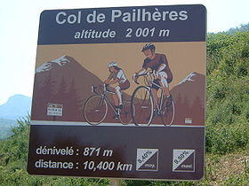
Sign at Mijanès at the start of the Port de PailhèresElevation 2,001 m (6,565 ft) Traversed by D25 Location Location of Port de Pailhères Location Ariège,  France
Range Pyrenees Coordinates 42°44′0″N 01°59′33″E / 42.733333°N 1.9925°ECoordinates: 42°44′0″N 01°59′33″E / 42.733333°N 1.9925°E The Port de Pailhères or (Col de Pailhères) is a pass in the Ariège department of the French Pyrenees.
The summit is at an altitude of 2,001 metres, and is located on the secondary road D25 between Mijanès (south-eastern) and Ax-les-Thermes (western).
Starting from Mijanes, the Col de Pailhères is 10.6 km long. Over this distance, the climb is 871 m. (an average percentage of 8.2%) with a maximum gradient of 10.2%.
Starting from Ax-les-Thermes, the Col de Pailhères is 18.6 km long. Over this distance, the climb is 1281 m. (an average percentage of 6.9%) with a maximum gradient of 10.4% near the summit.
The climb has been used in four stages of the Tour de France cycle race in 2003, 2005, 2007 (14th stage), and 2010 (14th stage).
Appearances in Tour de France
Year Stage Category Start Finish Leader at the summit 2010 14 HC Revel Ax-3 Domaines Christophe Riblon 2007 14 HC Mazamet Plateau-de-Beille Rubén Pérez 2005 14 HC Agde Ax-3 Domaines Georg Totschnig 2003 13 1 Toulouse Ax-3 Domaines Juan Miguel Mercado See also
- List of highest paved roads in Europe
- List of mountain passes
External links
Categories:- Mountain passes of France
- Mountain passes of the Pyrenees
- Climbs in cycle racing
- 2007 Tour de France
Wikimedia Foundation. 2010.

