- Clear Airport
-
Clear Airport 
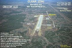
IATA: none – ICAO: PACL – FAA LID: Z84 Summary Airport type Public / Military Owner State of Alaska DOT&PF – Northern Region Serves Clear, Alaska Elevation AMSL 552 ft / 168 m Coordinates 64°18′04″N 149°07′13″W / 64.30111°N 149.12028°W Runways Direction Length Surface ft m 1/19 4,000 1,219 Asphalt Statistics (2005) Aircraft operations 2,000 Based aircraft 12 Source: Federal Aviation Administration[1] Clear Airport (ICAO: PACL[2], FAA LID: Z84) is a state-owned public-use airport located three nautical miles (6 km) southeast of the central business district of Clear, Alaska, United States.[1]
Facilities and aircraft
Clear Airport covers an area of 1,127 acres (456 ha) at an elevation of 552 feet (168 m) above mean sea level. It has one runway designated 1/19 with a 4,000 by 100 ft (1,219 x 30 m) asphalt pavement.[1]
For the 12-month period ending December 31, 2005, the airport had 2,000 aircraft operations, an average of 166 per month: 75% general aviation and 25% military. At that time there were 12 aircraft based at this airport, all single-engine.[1]
References
- ^ a b c d FAA Airport Master Record for Z84 (Form 5010 PDF), retrieved 2008-07-31.
- ^ FAA Location Identifiers (Order 7350.7Z): Alaskan ICAO Identifiers (Section 6G). Federal Aviation Administration. 2007-03-15.
External links
- FAA Alaska airport diagram (GIF)
- Resources for this airport:
- AirNav airport information for Z84
- FlightAware airport information and live flight tracker
- SkyVector aeronautical chart for Z84
Categories:- Airports in Denali Borough, Alaska
- Alaska airport stubs
Wikimedia Foundation. 2010.
