- McLeansboro Township, Hamilton County, Illinois
-
McLeansboro Township — Township — Location in Hamilton County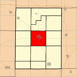 Hamilton County's location in Illinois
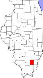
Coordinates: 38°04′52″N 88°32′27″W / 38.08111°N 88.54083°WCoordinates: 38°04′52″N 88°32′27″W / 38.08111°N 88.54083°W Country  United States
State  Illinois
County Hamilton Established November 3, 1885 Area - Total 35.93 sq mi (93.05 km2) - Land 35.66 sq mi (92.35 km2) - Water 0.27 sq mi (0.7 km2) 0.75% Elevation 446 ft (136 m) Population (2000) - Total 3,917 - Density 109.8/sq mi (42.4/km2) Time zone CST (UTC-6) - Summer (DST) CDT (UTC-5) ZIP code 62859 GNIS feature ID 0429303 McLeansboro Township is one of twelve townships in Hamilton County, Illinois, USA. As of the 2000 census, its population was 3,917[1].
Contents
Geography
According to the United States Census Bureau, McLeansboro Township covers an area of 35.93 square miles (93.1 km2); of this, 35.66 square miles (92.4 km2) (99.25 percent) is land and 0.27 square miles (0.70 km2) (0.75 percent) is water.
Cities, towns, villages
Unincorporated towns
- Diamond City at 38°05′21″N 88°33′09″W / 38.0892146°N 88.5525527°W
- Hoodville at 38°02′57″N 88°31′38″W / 38.0492144°N 88.5272738°W
(This list is based on USGS data and may include former settlements.)
Cemeteries
The township contains these six cemeteries: Crisel, Glenview Memorial Gardens, Hutson, Independent Order of Oddfellows, Presley and Union Hill.
Airports and landing strips
- McLeansboro Airport
School districts
- Hamilton County Community Unit School District 10
Political districts
- Illinois's 19th congressional district
- State House District 117
- State House District 118
- State Senate District 59
References
- "McLeansboro Township, Hamilton County, Illinois". Geographic Names Information System, U.S. Geological Survey. http://geonames.usgs.gov/pls/gnispublic/f?p=gnispq:3:::NO::P3_FID:0429303. Retrieved 2010-07-06.
- United States Census Bureau 2009 TIGER/Line Shapefiles
- United States National Atlas
External links
- City-Data.com
- Illinois State Archives
- Township Officials of Illinois
- Hamilton County Historical Society

Dahlgren Township South Crouch Township Beaver Creek Township Knights Prairie Township 
Crook Township  McLeansboro Township

Flannigan Township Twigg Township Mayberry Township Municipalities and communities of Hamilton County, Illinois County seat: McLeansboro Cities 
Town Villages Townships Beaver Creek | Crook | Crouch | Dahlgren | Flannigan | Knights Prairie | Mayberry | McLeansboro | South Crouch | South Flannigan | South Twigg | Twigg
Unincorporated
communitiesFootnotes ‡This populated place also has portions in an adjacent county or counties
Categories:- Townships in Hamilton County, Illinois
- Mount Vernon, Illinois micropolitan area


Wikimedia Foundation. 2010.