- Crook Township, Hamilton County, Illinois
-
Crook Township — Township — Location in Hamilton County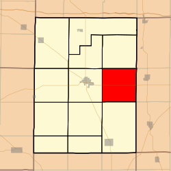 Hamilton County's location in Illinois
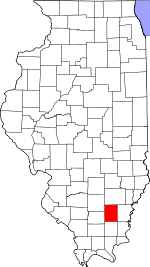
Coordinates: 38°04′43″N 88°25′59″W / 38.07861°N 88.43306°WCoordinates: 38°04′43″N 88°25′59″W / 38.07861°N 88.43306°W Country  United States
State  Illinois
County Hamilton Established November 3, 1885 Area - Total 35.98 sq mi (93.19 km2) - Land 35.84 sq mi (92.83 km2) - Water 0.14 sq mi (0.36 km2) 0.39% Elevation 469 ft (143 m) Population (2000) - Total 347 - Density 9.7/sq mi (3.7/km2) Time zone CST (UTC-6) - Summer (DST) CDT (UTC-5) ZIP codes 62835, 62859 GNIS feature ID 0428857 Crook Township is one of twelve townships in Hamilton County, Illinois, USA. As of the 2000 census, its population was 347[1].
Contents
Geography
According to the United States Census Bureau, Crook Township covers an area of 35.98 square miles (93.2 km2); of this, 35.84 square miles (92.8 km2) (99.61 percent) is land and 0.14 square miles (0.36 km2) (0.39 percent) is water.
Unincorporated towns
- Thackeray at 38°07′12″N 88°27′11″W / 38.1200475°N 88.4531046°W
- Thurber at 38°04′57″N 88°25′39″W / 38.0825473°N 88.4275479°W
(This list is based on USGS data and may include former settlements.)
Extinct towns
- Jamestown at 38°02′20″N 88°22′27″W / 38.0389358°N 88.3742125°W
- Logansport at 38°06′21″N 88°25′24″W / 38.1058806°N 88.4233812°W
(These towns are listed as "historical" by the USGS.)
Cemeteries
The township contains these seven cemeteries: Arterberry, Hopkins, Munsell, New Hope, Old Brush Harbor, Prince and Webb.
Major highways
Lakes
- L P Dolan Lake
School districts
- Hamilton County Community Unit School District 10
- Norris City-Omaha-Enfield Community Unit School District 3
Political districts
- Illinois's 19th congressional district
- State House District 117
- State House District 118
- State Senate District 59
References
- United States Census Bureau 2008 TIGER/Line Shapefiles
- "Crook Township". Geographic Names Information System, U.S. Geological Survey. http://geonames.usgs.gov/pls/gnispublic/f?p=gnispq:3:::NO::P3_FID:0428857. Retrieved 2009-09-24.
- United States National Atlas
External links
- Hamilton County Historical Society
- City-Data.com
- Illinois State Archives
- Township Officials of Illinois
Municipalities and communities of Hamilton County, Illinois County seat: McLeansboro Cities 
Town Villages Townships Beaver Creek | Crook | Crouch | Dahlgren | Flannigan | Knights Prairie | Mayberry | McLeansboro | South Crouch | South Flannigan | South Twigg | Twigg
Unincorporated
communitiesFootnotes ‡This populated place also has portions in an adjacent county or counties
Categories:- Townships in Hamilton County, Illinois
- Mount Vernon, Illinois micropolitan area


Wikimedia Foundation. 2010.