- North Fork Township, Gallatin County, Illinois
-
North Fork Township — Township — Location in Gallatin County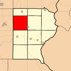 Gallatin County's location in Illinois
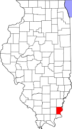
Coordinates: 37°49′10″N 88°19′12″W / 37.81944°N 88.32°WCoordinates: 37°49′10″N 88°19′12″W / 37.81944°N 88.32°W Country United States State Illinois County Gallatin Established November 5, 1890 Area – Total 36.77 sq mi (95.24 km2) – Land 36.46 sq mi (94.44 km2) – Water 0.31 sq mi (0.79 km2) 0.83% Elevation 374 ft (114 m) Population (2000) – Total 523 – Density 14.3/sq mi (5.5/km2) Time zone CST (UTC-6) – Summer (DST) CDT (UTC-5) ZIP codes 62871, 62930, 62934, 62979 GNIS feature ID 0429458 North Fork Township is one of ten townships in Gallatin County, Illinois, USA. As of the 2000 census, its population was 523[1].
Contents
Geography
According to the United States Census Bureau, North Fork Township covers an area of 36.77 square miles (95.2 km2); of this, 36.46 square miles (94.4 km2) (99.16 percent) is land and 0.31 square miles (0.80 km2) (0.83 percent) is water.
Cities, towns, villages
- Ridgway (west quarter)
Unincorporated towns
(This list is based on USGS data and may include former settlements.)
Cemeteries
The township contains these six cemeteries: Campground, Garrett, Oak Grove Church, Saint Josephs, Union Chapel and Zion.
Major highways
School districts
- Eldorado Community Unit School District 4
- Gallatin Community Unit School District 7
Political districts
- Illinois' 19th congressional district
- State House District 118
- State Senate District 59
References
- "North Fork Township, Gallatin County, Illinois". Geographic Names Information System, U.S. Geological Survey. http://geonames.usgs.gov/pls/gnispublic/f?p=gnispq:3:::NO::P3_FID:0429458. Retrieved 2010-01-17.
- United States Census Bureau 2007 TIGER/Line Shapefiles
- United States National Atlas
External links
Municipalities and communities of Gallatin County, Illinois City 
Villages Townships Asbury | Bowlesville | Eagle Creek | Equality | Gold Hill | New Haven | North Fork | Omaha | Ridgway | Shawnee
Unincorporated
communitiesCottonwood | Elba | Gibsonia | Inman | Kedron | Lawler | Leamington
Categories:- Townships in Gallatin County, Illinois


Wikimedia Foundation. 2010.