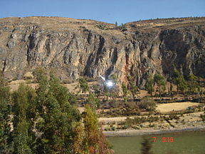
- Mantaro River
-
Mantaro (river) 
View of Mantaro riverOrigin Lake Junin Mouth Ene River Basin countries  Peru
PeruLength 724 km (450 mi) Source elevation 4.080 m (13.39 ft) Basin area 15.410 km2 (5.950 sq mi)Amazon basin River system Amazon Left tributaries Cunas River Right tributaries Ichu River The Mantaro River (Spanish: Río Mantaro,Quechua: Hatunmayo) is a long river running through the central region of Peru. Its Quechua name means "great river".
Geography
The river has its source at Lake Junín at a height of 4.080 m and runs through Junín, Yauli, Jauja, Concepción and Huancayo provinces in Junín Region, then through Huancavelica Region and Ayacucho Region, then returns to Junín Region in Satipo Province where it unites with the Apurimac River to form the Ene River. Its hydrographic basin also includes some of the Pasco Region. The river belongs to the hydrographic basin of the Amazon River. Its principal tributaries are the Cunas River and the Ichu River.
The river runs from northeast to southeast through the Mantaro Valley. This valley is the most important food source for the capital Lima.
The Mantaro Hydroelectric Complex is located in the Tayacaja Province of Huancavelica Region, and produces 31% of all electrical energy generated in Peru.[1]
The word "Mantaro" may be a word originally from the Ashaninka language, who live downstream along the Ene River.
Notes
- ^ "Complejo Hidroenergético del Mantaro" (in Spanish). ElectroPeru. http://www.electroperu.com.pe/Super_FSet.asp?dato=211.
Categories:- Rivers of Peru
Wikimedia Foundation. 2010.
