Newbold-on-Avon

Newbold-on-Avon

Coordinates: 52°23′25″N 1°16′53″W / 52.390337°N 1.2812514°W / 52.390337; -1.2812514

Newbold-on-Avon
Newbold canal tunnel.jpg
Newbold canal tunnel
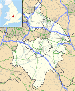
Newbold-on-Avon is located in Warwickshire
Newbold-on-Avon

 Newbold-on-Avon shown within Warwickshire
Population 1,548 (2001)
OS grid reference SP495765
Parish Newbold-on-Avon
District Rugby
Shire county Warwickshire
Region West Midlands
Country England
Sovereign state United Kingdom
Post town RUGBY
Postcode district CV21
Dialling code 01788
Police Warwickshire
Fire Warwickshire
Ambulance West Midlands
EU Parliament West Midlands
UK Parliament Rugby and Kenilworth
List of places: UK • England • Warwickshire

Newbold-on-Avon is an area of Rugby in Warwickshire, England, located around 1½ miles north-west of the town centre. Newbold was historically a village in its own right, but was incorporated into Rugby in 1932. The name is derived from the Saxon Niowebold ('New house').

Newbold keeps its village character in places, but modern housing estates surround the old village core. In the old village is the church of St Botolph, which dates from the 15th century.

The River Avon and the Oxford Canal go between Newbold and Rugby. The canal goes through the 189-metre-long Newbold Tunnel, built in the 1830s to replace an older tunnel which went on a different route. Remains of the old tunnel can be seen next to the churchyard.

There are some former quarries in the Newbold area. One of them has been converted into a nature reserve, known as Newbold Quarry Park.

The main secondary school in Newbold is Avon Valley School.

External links

Media related to Newbold-on-Avon at Wikimedia Commons


Wikimedia Foundation. 2010.

Игры ⚽ Нужно сделать НИР?

Look at other dictionaries:

  • Newbold — can refer to: Contents 1 People 1.1 Given name 1.2 Surname 2 …   Wikipedia

  • Newbold College — Motto A mind opening experience Established 1901[1] Type …   Wikipedia

  • Newbold on Stour — Coordinates: 52°06′50″N 1°38′24″W / 52.114°N 1.640°W / 52.114; 1.640 …   Wikipedia

  • Avon Valley School — Infobox UK school name = The Avon Valley School and Performing Arts College size = latitude = 52.38485 longitude = 1.27350 dms = dms motto = motto pl = established = approx = closed = c approx = type = religion = president = head label =… …   Wikipedia

  • Stratford-on-Avon (district) — Borough name=Stratford on Avon admin=Warwickshire status=Non metropolitan district region=West Midlands (region)!West Midlands arearank=26 sqkm=977.87 HQ=Stratford upon Avon ONS=44UE ethnicity=96.5% White 1.4% S.Asian website=… …   Wikipedia

  • Oxford Canal — The Oxford Canal as seen from Napton on the Hill in Warwickshire The Oxford Canal is a 78 mile long (126 km) narrow canal in central England linking Oxford with Coventry via Banbury and Rugby. It connects with the River Thames at Oxford, to… …   Wikipedia

  • Rugby, Warwickshire — Infobox UK place country = England official name= Rugby latitude= 52.37 longitude= 1.26 civil parish= population = 61,988 (2001 Census) shire district= Rugby shire county= Warwickshire region= West Midlands constituency westminster= Rugby and… …   Wikipedia

  • List of places in Warwickshire — This is a list of cities, towns and villages in the ceremonial county of Warwickshire, England. See the list of places in England for places in other counties.compactTOC NOTOC AAdmington, Alcester, Alderminster, Alveston, Ansley, Arley, Ansty,… …   Wikipedia

  • Diocese of Coventry — Location Ecclesiastical province Canterbury Archdeaconries Warwick, Coventry Statistics Parishes …   Wikipedia

  • Rugby (Warwickshire) — Rugby Rugby Market Place Koordinaten …   Deutsch Wikipedia

Share the article and excerpts

Direct link
Do a right-click on the link above
and select “Copy Link”