Criffel

Criffel
Criffel

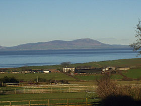
Criffel from Crosby, Cumbria
Elevation 570 m (1,870 ft)
Prominence 488 m (1,601 ft)
Listing Marilyn
Location
Location Dumfries and Galloway,  Scotland
Range Southern Uplands
Topo map OS Landranger 84
OS grid NX957618

Criffel is a hill in southern Galloway, Scotland. It is 570 metres high but appears higher because of its great isolation and high relative height — it is the eighth most prominent hill in Southern Scotland. It is a prominent feature in many of the views from the northern Lake District on a clear day. It is surrounded by a host of satellites, including Long Fell, Maidenpap and Bainloch Hill.

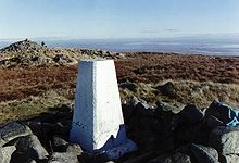
Trig point and Douglas's Cairn, Criffel

See also

Coordinates: 54°56′24″N 3°37′47″W / 54.93992°N 3.62961°W / 54.93992; -3.62961


Wikimedia Foundation. 2010.

Игры ⚽ Поможем решить контрольную работу

Look at other dictionaries:

  • Criffel — Criffel, Berg, s. Kirkcudbrightshire …   Meyers Großes Konversations-Lexikon

  • Criffel Peak View Bed & Breakfast — (Ванака,Новая Зеландия) Категория отеля: 3,5 звезд Адрес: 98 Hedditch St …   Каталог отелей

  • Criffel Apartment — (Ванака,Новая Зеландия) Категория отеля: 4 звездочный отель Адрес: 98 Hedditch St …   Каталог отелей

  • Crossens — Coordinates: 53°40′11″N 2°56′55″W / 53.6697°N 2.9487°W / 53.6697; 2.9487 …   Wikipedia

  • Newabbey —    NEWABBEY, a parish, in the stewartry of Kirkcudbright; containing 1049 inhabitants, of whom 330 are in the village, 7 miles (S. by W.) from Dumfries. This place, anciently called Kirkindar from the situation of the old church on an island in… …   A Topographical dictionary of Scotland

  • Kirkcudbrightshire —   County (until circa 1890)   Country Scotland …   Wikipedia

  • Kirkbean —    KIRKBEAN, a parish, in the stewartry of Kirkcudbright, 12 miles (S.) from Dumfries; containing, with the villages of Carsethorn and Preston Mill, 891 inhabitants, of whom 91 are in the village of Kirkbean. This parish, of which the name, in… …   A Topographical dictionary of Scotland

  • Dumfries — For other uses, see Dumfries (disambiguation). Coordinates: 55°04′12″N 3°36′11″W / 55.070°N 3.603°W / 55.070; 3.603 …   Wikipedia

  • Dumfries and Galloway — See also: Dumfries and Galloway (UK Parliament constituency) Dumfries and Galloway Dumfries an Gallowa Dùn Phris is Gall Ghaidhealaibh Logo Location …   Wikipedia

  • Scafell Pike — viewed from Wastwater Elevation 978 m (3,209 ft) …   Wikipedia

Share the article and excerpts

Direct link
Do a right-click on the link above
and select “Copy Link”