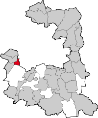
- Neuried, Bavaria
-
Neuried 
Coordinates 48°5′36″N 11°27′57″E / 48.09333°N 11.46583°ECoordinates: 48°5′36″N 11°27′57″E / 48.09333°N 11.46583°E Administration Country Germany State Bavaria Admin. region Upper Bavaria District Munich Mayor Ilse Weiß (CSU) Basic statistics Area 9.63 km2 (3.72 sq mi) Elevation 559 m (1834 ft) Population 8,411 (31 December 2010)[1] - Density 873 /km2 (2,262 /sq mi) Other information Time zone CET/CEST (UTC+1/+2) Licence plate M Postal code 82061 Area code 089 Website www.neuried.de Neuried is a municipality in the district of Munich in Bavaria in Germany.
References
- ^ "Fortschreibung des Bevölkerungsstandes" (in German). Bayerisches Landesamt für Statistik und Datenverarbeitung. 31 December 2010. https://www.statistikdaten.bayern.de/genesis/online?language=de&sequenz=tabelleErgebnis&selectionname=12411-009r&sachmerkmal=QUASTI&sachschluessel=SQUART04&startjahr=2010&endjahr=2010.
Aschheim | Aying | Baierbrunn | Brunnthal | Feldkirchen | Garching bei München | Gräfelfing | Grasbrunn | Grünwald | Haar | Hohenbrunn | Höhenkirchen-Siegertsbrunn | Ismaning | Kirchheim bei München | Neubiberg | Neuried | Oberhaching | Oberschleißheim | Ottobrunn | Planegg | Pullach | Putzbrunn | Sauerlach | Schäftlarn | Straßlach-Dingharting | Taufkirchen | Unterföhring | Unterhaching | Unterschleißheim Categories:
- Municipalities in Bavaria
- Munich district
- Upper Bavaria geography stubs
Wikimedia Foundation. 2010.


