- Colbitz
-
Colbitz 

 ColbitzLocation of Colbitz within Börde district
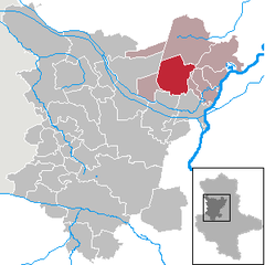
Coordinates 52°19′N 11°37′E / 52.31667°N 11.61667°ECoordinates: 52°19′N 11°37′E / 52.31667°N 11.61667°E Administration Country Germany State Saxony-Anhalt District Börde Municipal assoc. Elbe-Heide Local subdivisions 4 Mayor Heinz Kühnel Basic statistics Area 71.85 km2 (27.74 sq mi) Elevation 67 m (220 ft) Population 3,302 (31 December 2010)[1] - Density 46 /km2 (119 /sq mi) Other information Time zone CET/CEST (UTC+1/+2) Licence plate BK Postal code 39326 Area code 039207 Website www.gemeinde-colbitz.de Colbitz is a municipality in the Börde district in Saxony-Anhalt, Germany.
Colbitz is well known for its "Colbitzer" beer and the Colbitz-Letzlinger Heide. The Colbitz-Letzlinger Heide is found in the northern area of Colbitz, but most parts of the heath landscape are used by the Bundeswehr - the German army.
External links
- The Colbitzer Brewery (has information about area's history) (German)
- Official website of Colbitz (German)
References
- ^ "Bevölkerung der Gemeinden nach Landkreisen" (in German). Statistisches Landesamt Sachsen-Anhalt. 31 December 2010. http://www.statistik.sachsen-anhalt.de/download/stat_berichte/6A102_hj_2010_02.pdf.
Altenhausen | Am Großen Bruch | Angern | Ausleben | Barleben | Beendorf | Bülstringen | Burgstall | Calvörde | Colbitz | Eilsleben | Erxleben | Flechtingen | Gröningen | Haldensleben | Harbke | Hohe Börde | Hötensleben | Ingersleben | Kroppenstedt | Loitsche-Heinrichsberg | Niedere Börde | Oebisfelde-Weferlingen | Oschersleben | Rogätz | Sommersdorf | Sülzetal | Süplingen | Ummendorf | Völpke | Wanzleben-Börde | Wefensleben | Westheide | Wolmirstedt | Zielitz Categories:
- Municipalities in Saxony-Anhalt
- Towns in Saxony-Anhalt
- Börde
- Börde geography stubs


Wikimedia Foundation. 2010.